Country:
 USA
USARegion:
City:
Latitude and Longitude:
Time Zone:
Postal Code:
IP information under different IP Channel
ip-api
Country
Region
City
ASN
Time Zone
ISP
Blacklist
Proxy
Latitude
Longitude
Postal
Route
IPinfo
Country
Region
City
ASN
Time Zone
ISP
Blacklist
Proxy
Latitude
Longitude
Postal
Route
MaxMind
Country
Region
City
ASN
Time Zone
ISP
Blacklist
Proxy
Latitude
Longitude
Postal
Route
Luminati
Country
USASN
Time Zone
America/Chicago
ISP
Ses Astra S.A.
Latitude
Longitude
Postal
db-ip
Country
Region
City
ASN
Time Zone
ISP
Blacklist
Proxy
Latitude
Longitude
Postal
Route
ipdata
Country
Region
City
ASN
Time Zone
ISP
Blacklist
Proxy
Latitude
Longitude
Postal
Route
Popular places and events near this IP address

Warp Drive
Short street in Sterling, Virginia
Distance: Approx. 792 meters
Latitude and longitude: 39.01379,-77.42991
Warp Drive is a short street in Sterling, Virginia, United States. Originally named Steeplechase Drive, it is located in an industrial park off Atlantic Boulevard, and primarily serves as the address for Northrop Grumman Innovation Systems, an aerospace company. The street ends at a circle where an off-ramp from Virginia State Highway 28 joins from the opposite direction.
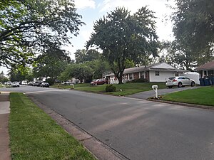
Sterling, Virginia
Census-designated place in Virginia
Distance: Approx. 78 meters
Latitude and longitude: 39.00611111,-77.42861111
Sterling, Virginia, refers most specifically to a census-designated place (CDP) in Loudoun County, Virginia, United States. The population of the CDP as of the 2020 United States Census was 30,337 The CDP boundaries are confined to a relatively small area between Virginia State Route 28 on the west and Virginia State Route 7 on the northeast, excluding areas near SR 606 and the Dulles Town Center. A much wider region has a preferred mailing address of "Sterling, Virginia", per the United States Postal Service.
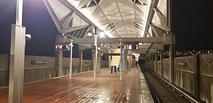
Loudoun Gateway station
Washington Metro station
Distance: Approx. 3216 meters
Latitude and longitude: 38.99277778,-77.46166667
Loudoun Gateway station is a Washington Metro station in Loudoun County, Virginia, on the Silver Line. It is located at SR 606 (Old Ox Road) and the ramps to SR 267. Originally planned to begin operations in 2016, the station opened on November 15, 2022.

Park View High School (Loudoun County, Virginia)
High school in Sterling, Virginia, United States
Distance: Approx. 2616 meters
Latitude and longitude: 39.015,-77.40080556
Park View High School is a public secondary school in Sterling, an unincorporated area in Loudoun County, Virginia, United States. The school is part of Loudoun County Public Schools and is located at 400 West Laurel Avenue in the Sterling Park community.
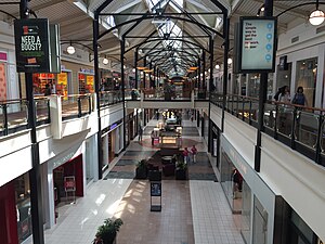
Dulles Town Center
Shopping mall in Dulles, Virginia
Distance: Approx. 2868 meters
Latitude and longitude: 39.03213889,-77.42383333
Dulles Town Center is a two-level enclosed shopping mall in Sterling in Loudoun County, Virginia. It is located five miles (8.0 km) north of Washington Dulles International Airport. It is part of the Dulles Town Center census-designated place for population statistical purposes.
Oak Grove, Loudoun County, Virginia
Census-designated place in Virginia
Distance: Approx. 2609 meters
Latitude and longitude: 38.98472222,-77.41861111
Oak Grove is a census-designated place in Loudoun County, Virginia, United States. The population as of the 2010 United States Census was 1,777. Oak Grove is located in eastern Loudoun County, on the Fairfax County border, between the communities of Sterling Park and Herndon.
Dulles Town Center, Virginia
Census-designated place in Virginia
Distance: Approx. 2283 meters
Latitude and longitude: 39.02416667,-77.41527778
Dulles Town Center is a census-designated place (CDP) in Loudoun County, Virginia, United States. It is located about 7 miles (11 km) north of Washington Dulles International Airport. The CDP is the location of the Dulles Town Center shopping mall, for which it is named.
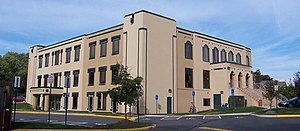
Loudoun School for Advanced Studies
Private school in Ashburn, Virginia, United States
Distance: Approx. 2560 meters
Latitude and longitude: 39.0174,-77.4553
Loudoun School for Advanced Studies (LSAS) is a private school in Ashburn, Virginia, United States and is designed to inspire and challenge advanced students in grades 6-12. Students from LSAS worked to rehabilitate the historic Ashburn Colored School, which is located on the same property where LSAS has built its new campus.

Broad Run Bridge and Tollhouse
United States historic place
Distance: Approx. 4462 meters
Latitude and longitude: 39.04666667,-77.43305556
The Broad Run Bridge and Tollhouse were built for the Leesburg Turnpike Company in Loudoun County, Virginia. The stone bridge, built about 1820, was a permanent replacement for a series of wood bridges at the location, with at least three that had been washed away between 1771 and 1803. The bridge spanned Broad Run on two arches with prominent conical buttresses.

Vestal's Gap Road and Lanesville Historic District
Historic district in Virginia, United States
Distance: Approx. 2553 meters
Latitude and longitude: 39.0175,-77.40305556
Vestal's Gap Road and Lanesville Historic District is a national historic district located in Claude Moore Park at Sterling, Loudoun County, Virginia. It encompasses 1 contributing building and 1 contributing structure. They are "Lanesville," a two-story side-gabled frame house on a solid stone-rubble foundation built about 1807, and a section of the former Vestal's Gap Road, an 18th-century road.
All Dulles Area Muslim Society
Distance: Approx. 4303 meters
Latitude and longitude: 39.00639,-77.37936
All Dulles Area Muslim Society (ADAMS) is one of the largest mosques in the United States, located in Sterling, VA and serving 5000 Muslim families. ADAMS offers a wide variety of services. Some are of religious nature such as Islamic and Arabic classes, while others are of communal nature such as Boy and Girl Scout activities.
Kincora, Virginia
Census-designated place in Virginia, United States
Distance: Approx. 3997 meters
Latitude and longitude: 39.04222222,-77.43583333
Kincora is a census-designated place in Loudoun County, Virginia, United States. The CDP was first drawn prior to the 2020 census.
Weather in this IP's area
clear sky
15 Celsius
15 Celsius
13 Celsius
17 Celsius
1016 hPa
63 %
1016 hPa
1006 hPa
10000 meters
4.63 m/s
340 degree
06:44:29
19:31:02