Country:
 USA
USARegion:
City:
Latitude and Longitude:
Time Zone:
Postal Code:
IP information under different IP Channel
ip-api
Country
Region
City
ASN
Time Zone
ISP
Blacklist
Proxy
Latitude
Longitude
Postal
Route
IPinfo
Country
Region
City
ASN
Time Zone
ISP
Blacklist
Proxy
Latitude
Longitude
Postal
Route
MaxMind
Country
Region
City
ASN
Time Zone
ISP
Blacklist
Proxy
Latitude
Longitude
Postal
Route
Luminati
Country
USRegion
wi
City
menomonie
ASN
Time Zone
America/Chicago
ISP
WWTC-247-01
Latitude
Longitude
Postal
db-ip
Country
Region
City
ASN
Time Zone
ISP
Blacklist
Proxy
Latitude
Longitude
Postal
Route
ipdata
Country
Region
City
ASN
Time Zone
ISP
Blacklist
Proxy
Latitude
Longitude
Postal
Route
Popular places and events near this IP address

Menomonie (town), Wisconsin
Town in Wisconsin, United States
Distance: Approx. 3005 meters
Latitude and longitude: 44.88138889,-91.96055556
Menomonie is a town in Dunn County, Wisconsin, United States. The population was 3,174 at the 2000 census. The unincorporated community of Irvington lies within the town, as does most of the City of Menomonie.

Menomonie, Wisconsin
City in Wisconsin, United States
Distance: Approx. 1285 meters
Latitude and longitude: 44.87916667,-91.91805556
Menomonie () is a city in and the county seat of Dunn County in the western part of the U.S. state of Wisconsin. The city's population was 16,843 as of the 2020 census. Named for the original inhabitants of the area, the Menominee, the city forms the core of the United States Census Bureau's Menomonie Micropolitan Statistical Area (MSA), which includes all of Dunn County (2010 population: 43,857).

University of Wisconsin–Stout
Public university in Menomonie, Wisconsin, U.S.
Distance: Approx. 111 meters
Latitude and longitude: 44.86972222,-91.92777778
The University of Wisconsin–Stout (UW–Stout or Stout) is a public university in Menomonie, Wisconsin, United States. The sole polytechnic university among the Universities of Wisconsin, it enrolls more than 6,900 students. The school was founded in 1891 and named in honor of its founder, lumber magnate James Huff Stout.

Tainter Lake
Reservoir in Dunn County, Wisconsin
Distance: Approx. 7900 meters
Latitude and longitude: 44.935,-91.88861111
Tainter Lake is a small reservoir in north central Dunn County, Wisconsin, on the Red Cedar River at its confluence with the Hay River. The lake was created by a hydroelectric dam (about 3 miles (5 km) downstream on the Red Cedar at Cedar Falls. The lake, a popular resort and fishing spot, has a surface area of approximately 2 square miles (5 km2).

Lake Menomin
Reservoir in northwestern Wisconsin
Distance: Approx. 1638 meters
Latitude and longitude: 44.88388889,-91.92916667
Lake Menomin is a reservoir on the Red Cedar River, in Dunn County, Wisconsin, USA. Its name is derived from the Ojibwe name for this lake, Manoominikaani-zaaga'igan meaning "Abundant with Wild Rice Lake." Along the lake's western and southern shores lies the city of Menomonie, the central business district of which is located at the far southern end of the lake, near the dam which forms it. There are multiple public parks, trails, beaches, and boat landings along the lake's shoreline. Common fish found in lake Menomin include Panfish, Largemouth and Smallmouth Bass, Northern Pike, and Walleye.
Don and Nona Williams Stadium
Stadium in Menomonie, Wisconsin, US
Distance: Approx. 216 meters
Latitude and longitude: 44.868097,-91.928648
Don and Nona Williams Stadium is a football stadium located on the campus of the University of Wisconsin–Stout in Menomonie, Wisconsin. The stadium is home to the UW–Stout Blue Devils, the Menomonie High School Mustangs, plus other high school games, as well as other sports at UW–Stout. The stadium is named in honor of Don Williams, a former member of the UW–Stout Board of Directors, and his wife, Nona.

Evergreen Cemetery (Menomonie, Wisconsin)
Historic cemetery in Dunn County, Wisconsin
Distance: Approx. 2571 meters
Latitude and longitude: 44.88915,-91.90983
Evergreen Cemetery is a cemetery in Menomonie, Wisconsin and the largest in Dunn County. It was founded as a private cemetery by Knapp Stout and Company, Menomonie's huge lumber company. There are over 1100 graves in the "single grave" section of the cemetery, however many lack headstones because the earliest families could not afford to purchase them on a mill worker's salary.

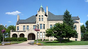
Mabel Tainter Memorial Building
United States historic place
Distance: Approx. 829 meters
Latitude and longitude: 44.87666667,-91.92805556
The Mabel Tainter Center for the Arts, originally named the Mabel Tainter Memorial Building and also known as the Mabel Tainter Theater, is a historic landmark in Menomonie, Wisconsin, and is registered on the U.S. National Register of Historic Places.
Irvington, Wisconsin
Unincorporated community in Wisconsin, United States
Distance: Approx. 4314 meters
Latitude and longitude: 44.83611111,-91.95472222
Irvington is an unincorporated community located in the town of Menomonie, Dunn County, Wisconsin, United States. Irvington is located on the Red Cedar River 3 miles (4.8 km) south-southwest of the city of Menomonie. Irvington is located on the Red Cedar State Trail and has parking facilities for trail access.
Louis Smith Tainter House
Historic house in Wisconsin, United States
Distance: Approx. 1088 meters
Latitude and longitude: 44.87888889,-91.92916667
The Louis Smith Tainter House is a historic building in Menomonie, Wisconsin, United States. The building was built in 1889 by architect Harvey Ellis; it was funded by Andrew Tainter, a partner in Knapp, Stout & Co., as a home and wedding gift for his son Louis Smith Tainter. The building was built out of locally quarried sandstone in the Richardsonian Romanesque style.

Wilson Place Museum
Museum in Menomonie, Wisconsin
Distance: Approx. 1524 meters
Latitude and longitude: 44.8828,-91.92968
Wilson Place Museum is a house museum in Menomonie, Wisconsin.

Menomonie station
Distance: Approx. 906 meters
Latitude and longitude: 44.87611111,-91.93277778
The Chicago, St. Paul, Minneapolis and Omaha Railroad Depot is a former train station located in Menomonie, Wisconsin. It was added to the National Register of Historic Places in 2018.
Weather in this IP's area
clear sky
8 Celsius
7 Celsius
7 Celsius
10 Celsius
1021 hPa
81 %
1021 hPa
990 hPa
10000 meters
1.54 m/s
110 degree
07:11:04
18:40:35