Country:
 USA
USARegion:
City:
Latitude and Longitude:
Time Zone:
Postal Code:
IP information under different IP Channel
ip-api
Country
Region
City
ASN
Time Zone
ISP
Blacklist
Proxy
Latitude
Longitude
Postal
Route
IPinfo
Country
Region
City
ASN
Time Zone
ISP
Blacklist
Proxy
Latitude
Longitude
Postal
Route
MaxMind
Country
Region
City
ASN
Time Zone
ISP
Blacklist
Proxy
Latitude
Longitude
Postal
Route
Luminati
Country
USRegion
sc
City
lakecity
ASN
Time Zone
America/New_York
ISP
FTC-INET
Latitude
Longitude
Postal
db-ip
Country
Region
City
ASN
Time Zone
ISP
Blacklist
Proxy
Latitude
Longitude
Postal
Route
ipdata
Country
Region
City
ASN
Time Zone
ISP
Blacklist
Proxy
Latitude
Longitude
Postal
Route
Popular places and events near this IP address
Williamsburg County, South Carolina
County in South Carolina, United States
Distance: Approx. 8839 meters
Latitude and longitude: 33.63,-79.72
Williamsburg County is a county located in the U.S. state of South Carolina. As of the 2020 census its population was 31,026. The county seat and largest community is Kingstree.
Kingstree, South Carolina
City in South Carolina, United States
Distance: Approx. 4713 meters
Latitude and longitude: 33.67111111,-79.82861111
Kingstree is a city and the county seat of Williamsburg County, South Carolina, United States. The population was 3,328 at the 2010 census.
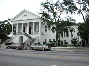
Kingstree Historic District
Historic district in South Carolina, United States
Distance: Approx. 5306 meters
Latitude and longitude: 33.66361111,-79.83083333
The Kingstree Historic District contains forty-eight properties situated along Main Street, Academy Street, and Hampton Street in the commercial area of downtown Kingstree, South Carolina. The district includes the courthouse, public library, railroad station, and numerous commercial buildings. The district is a fine collection of nineteenth-century vernacular commercial architecture.

Kingstree station
Passenger train station in Kingstree, South Carolina
Distance: Approx. 5167 meters
Latitude and longitude: 33.6637,-79.8291
Kingstree station is a train station in Kingstree, South Carolina, operated by Amtrak, the United States' railroad passenger system. It was originally built by the Atlantic Coast Line Railroad in 1909. The station survived the merger of the Atlantic Coast Line and Seaboard Air Line Railroads into the Seaboard Coast Line Railroad in 1967, only to terminate passenger service in 1971.
Williamsburg Regional Airport
Airport
Distance: Approx. 7510 meters
Latitude and longitude: 33.71722222,-79.85694444
Williamsburg Regional Airport (IATA: None, ICAO: KCKI, FAA LID: CKI) is a county-owned public-use airport located three nautical miles (3 mi, 5 km) west of the central business district of Kingstree, in Williamsburg County, South Carolina, United States. The airport is included in the FAA's National Plan of Integrated Airport Systems for 2011–2015, which categorized it as a general aviation facility. It has no scheduled commercial service.
Williamsburg Formation
Distance: Approx. 1955 meters
Latitude and longitude: 33.7,-79.8
The Williamsburg Formation is a geologic formation in South Carolina consisting of sandy shale and clayey sand. It is a member of the Black Mingo Group and overlays the Rhems Formation. It preserves fossils, among others coprolites, dating back to the Paleogene period.

Colonel John Gotea Pressley House
Historic house in South Carolina, United States
Distance: Approx. 5286 meters
Latitude and longitude: 33.67138889,-79.83555556
Colonel John Gotea Pressley House, also known as the Pressley-Hirsch-Green House and Wylma M. Green House is a historic home located at Kingstree, Williamsburg County, South Carolina. It was built in 1855, and is a 1+1⁄2-story, weatherboard-clad Greek Revival style frame dwelling. The front facade features a “rain porch” and a dormer with a Palladian window.

Scott House (Kingstree, South Carolina)
Historic house in South Carolina, United States
Distance: Approx. 3796 meters
Latitude and longitude: 33.67138889,-79.74833333
Scott House, also known as the Scott-Hauenstein House, is a historic home located at Kingstree, Williamsburg County, South Carolina. It was built about 1843, and is a two-story, three-bay, frame building, sheathed in weatherboard, with a side-gabled roof and brick foundation. The front façade features a "Carolina" or "rain porch." Its builder was Joseph Scott, a wealthy planter, trustee of the Kingstree Academy, and politician.

Thorntree (Kingstree, South Carolina)
Historic house in South Carolina, United States
Distance: Approx. 5058 meters
Latitude and longitude: 33.66222222,-79.82638889
Thorntree, also known as the Witherspoon House, is a historic plantation house located at Kingstree, Williamsburg County, South Carolina. It was built in 1749 by immigrant James Witherspoon (1700-1765), and is a two-story, five-bay, frame "I-house" dwelling with a hall and parlor plan and exterior end chimneys. It features full-length piazzas on the front and rear elevations.

M. F. Heller House
Historic house in South Carolina, United States
Distance: Approx. 5203 meters
Latitude and longitude: 33.66777778,-79.8325
M. F. Heller House, also known as the Arrowsmith House and Old Methodist Church Parsonage, is a historic home located at Kingstree, Williamsburg County, South Carolina. It was built about 1845 and enlarged about 1895 to a substantial two-story Late Victorian residence. It is a two-story, lateral-gabled residence, sheathed in weatherboard and set on a stuccoed brick pier foundation.
Williamsburg Technical College
College in Kingstree, South Carolina, U.S.
Distance: Approx. 4713 meters
Latitude and longitude: 33.67111111,-79.82861111
Williamsburg Technical College is a public community college in Kingstree, South Carolina. It is a part of the South Carolina Technical College System.

Epps-McGill Farmhouse
Victorian home
Distance: Approx. 3489 meters
Latitude and longitude: 33.67446944,-79.81581944
Epps-Mcgill Farmhouse is a two-story Folk Victorian style 3,658 square feet (339.8 m2)home located near Kingstree, in Williamsburg County, South Carolina. Construction of the home began in 1905 by Silas Wightman Epps. It was listed on the National Register of Historic Places in 2020.
Weather in this IP's area
broken clouds
23 Celsius
23 Celsius
23 Celsius
24 Celsius
1010 hPa
81 %
1010 hPa
1008 hPa
10000 meters
1.48 m/s
1.58 m/s
74 degree
56 %
07:05:32
19:20:04