Country:
 USA
USARegion:
City:
Latitude and Longitude:
Time Zone:
Postal Code:
IP information under different IP Channel
ip-api
Country
Region
City
ASN
Time Zone
ISP
Blacklist
Proxy
Latitude
Longitude
Postal
Route
IPinfo
Country
Region
City
ASN
Time Zone
ISP
Blacklist
Proxy
Latitude
Longitude
Postal
Route
MaxMind
Country
Region
City
ASN
Time Zone
ISP
Blacklist
Proxy
Latitude
Longitude
Postal
Route
Luminati
Country
USRegion
sc
City
sumter
ASN
Time Zone
America/New_York
ISP
FTC-INET
Latitude
Longitude
Postal
db-ip
Country
Region
City
ASN
Time Zone
ISP
Blacklist
Proxy
Latitude
Longitude
Postal
Route
ipdata
Country
Region
City
ASN
Time Zone
ISP
Blacklist
Proxy
Latitude
Longitude
Postal
Route
Popular places and events near this IP address

East Sumter, South Carolina
CDP in South Carolina, United States
Distance: Approx. 2803 meters
Latitude and longitude: 33.92472222,-80.29777778
East Sumter is a census-designated place (CDP) in Sumter County, South Carolina, United States. The population was 1,220 at the 2000 census. It is included in the Sumter, South Carolina Metropolitan Statistical Area.

Mulberry, South Carolina
CDP in South Carolina, United States
Distance: Approx. 1655 meters
Latitude and longitude: 33.949972,-80.335115
Mulberry is a census-designated place (CDP) in Sumter County, South Carolina, United States. The population was 841 at the 2000 census. It is included in the Sumter, South Carolina Metropolitan Statistical Area.

Sumter, South Carolina
City in Sumter County, South Carolina, United States
Distance: Approx. 3063 meters
Latitude and longitude: 33.92055556,-80.34166667
Sumter ( SUM-tər) is a city in and the county seat of Sumter County, South Carolina, United States. The city makes up the Sumter, SC Metropolitan Statistical Area. Sumter County, along with Clarendon and Lee counties, form the core of Sumter–Lee–Clarendon tri-county (or East Midlands) area of South Carolina that includes three counties straddling the border of the Sandhills (or Midlands), Pee Dee, and Lowcountry regions.
Morris College
Historiclly black private college in Sumter, South Carolina, US
Distance: Approx. 2374 meters
Latitude and longitude: 33.9383,-80.3457
Morris College (MC) is a private, Baptist historically black college in Sumter, South Carolina. It was founded and is operated by the Baptist Educational and Missionary Convention of South Carolina.
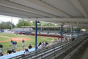
Riley Park (Sumter)
Stadium in Sumter, South Carolina, US
Distance: Approx. 2459 meters
Latitude and longitude: 33.934891,-80.345673
Riley Park is a stadium in Sumter, South Carolina, located at Church Street & DuBose Street, 29150. It is primarily used for baseball, has housed Sumter minor league baseball teams and is currently home to the University of South Carolina Sumter Fire Ants and Morris College Hornet baseball teams.

Sumter County Courthouse (South Carolina)
United States historic place
Distance: Approx. 2728 meters
Latitude and longitude: 33.92444444,-80.34138889
The Sumter County Courthouse, built in 1907, is an historic courthouse located at 141 North Main Street in the city of Sumter in Sumter County, South Carolina. It was designed in the Beaux Arts style by Darlington native William Augustus Edwards who designed eight other South Carolina courthouses as well as academic buildings at 12 institutions in Florida, Georgia and South Carolina. It was built in an I-shape.
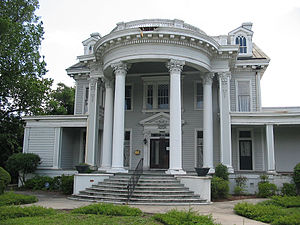
O'Donnell House (Sumter, South Carolina)
Historic house in South Carolina, United States
Distance: Approx. 3020 meters
Latitude and longitude: 33.91944444,-80.33916667
The O'Donnell House in Sumter, South Carolina, also known as Haynsworth-Bogin-O'Donnell House or as Shelley-Brunson Funeral Home, was built in 1840. It was listed on the National Register of Historic Places in 1996.

Heriot-Moise House
Historic house in South Carolina, United States
Distance: Approx. 2352 meters
Latitude and longitude: 33.96,-80.30777778
The Heriot-Moise House, also known as Ingleside, is an historic plantation house located on Brewington Road at Oswego Highway U.S Highway 401 north of Sumter in Sumter County, South Carolina. It is "significant for its illustration of evolving architectural forms and influences from ca. 1790 into the twentieth century, as altered from an essentially vernacular hall-and-parlor house to a residence with Early Classical revival and Greek revival influences.

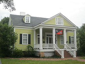
Henry Lee Scarborough House
Historic house in South Carolina, United States
Distance: Approx. 2383 meters
Latitude and longitude: 33.92833333,-80.34055556
Henry Lee Scarborough House, also known as Scarborough Homeplace, is a historic home located at Sumter, Sumter County, South Carolina. It was built in 1908–1909, and is a two-story, three-bay, frame Neo-Classical style dwelling. It features a full height portico supported by four massive columns with Corinthian order capitals.
Elizabeth White House
Historic house in South Carolina, United States
Distance: Approx. 2423 meters
Latitude and longitude: 33.92805556,-80.34083333
Elizabeth White House is a historic home in Sumter, Sumter County, South Carolina. It was built about 1854, and is a 1 1/2-story vernacular Greek Revival cottage. The front facade features a pedimented one-story portico supported by four square columns.

Sumter Town Hall-Opera House
United States historic place
Distance: Approx. 3040 meters
Latitude and longitude: 33.92083333,-80.34166667
Sumter Town Hall-Opera House, also known as the Sumter Academy of Music, is a historic town hall building located at Sumter, Sumter County, South Carolina. It was built in 1893, and is a four-story, ashlar brick Richardsonian Romanesque style building. It features a four-faced clock tower that serves as a focal point for the entire area.
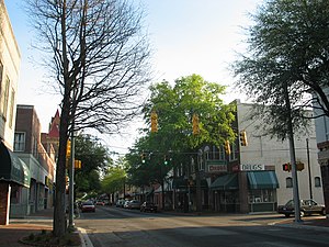
Sumter Historic District
Historic district in South Carolina, United States
Distance: Approx. 3087 meters
Latitude and longitude: 33.92027778,-80.34166667
Sumter Historic District is a national historic district located at Sumter, Sumter County, South Carolina. It encompasses 62 contributing buildings in the central business district of Sumter. It includes buildings that primarily date from 1880 to 1912.
Weather in this IP's area
clear sky
25 Celsius
26 Celsius
23 Celsius
26 Celsius
1011 hPa
81 %
1011 hPa
1006 hPa
10000 meters
07:07:38
19:22:15