216.215.94.173 - IP Lookup: Free IP Address Lookup, Postal Code Lookup, IP Location Lookup, IP ASN, Public IP
Country:
Region:
City:
Location:
Time Zone:
Postal Code:
ISP:
ASN:
language:
User-Agent:
Proxy IP:
Blacklist:
IP information under different IP Channel
ip-api
Country
Region
City
ASN
Time Zone
ISP
Blacklist
Proxy
Latitude
Longitude
Postal
Route
db-ip
Country
Region
City
ASN
Time Zone
ISP
Blacklist
Proxy
Latitude
Longitude
Postal
Route
IPinfo
Country
Region
City
ASN
Time Zone
ISP
Blacklist
Proxy
Latitude
Longitude
Postal
Route
IP2Location
216.215.94.173Country
Region
texas
City
houston
Time Zone
America/Chicago
ISP
Language
User-Agent
Latitude
Longitude
Postal
ipdata
Country
Region
City
ASN
Time Zone
ISP
Blacklist
Proxy
Latitude
Longitude
Postal
Route
Popular places and events near this IP address

Main Street Square station
Light rail station in Houston, Texas
Distance: Approx. 176 meters
Latitude and longitude: 29.7574,-95.36453611
Main Street Square is a station on the METRORail Red Line in Houston, Texas (USA). This originally was the 3rd station heading south along the rail line and is in the heart of downtown. There are many shopping areas and offices nearby.

CenterPoint Energy Plaza
Skyscraper in Houston, Texas
Distance: Approx. 162 meters
Latitude and longitude: 29.757214,-95.367962
CenterPoint Energy Tower (formerly Houston Industries Plaza) is a 741 feet (226 m) tall building in downtown Houston. The original building, finished in 1974, stood at 651 feet (198 m), but a 90-foot (27 m) extension was added as part of a 1996 renovation. Designed by Richard Keating, this renovation dramatically changed the building, the Houston Skyline and the downtown.
1000 Main
Skyscraper located in Houston Texas
Distance: Approx. 71 meters
Latitude and longitude: 29.7568,-95.3656
1000 Main, formerly Reliant Energy Plaza, is a 518-foot (158 m) tall skyscraper in Downtown Houston, Texas managed by Transwestern. It houses the headquarters of GenOn Energy, and the building has around 800,000 square feet (74,000 m2) of space. 1000 Main was constructed from 2001 to 2003 and has 36 floors.

El Paso Energy Building
Skyscraper located in Houston Texas
Distance: Approx. 146 meters
Latitude and longitude: 29.7579,-95.3674
The Kinder Morgan Building (formerly known as the El Paso Energy Building and before that the Tenneco Building) is a 502-foot (153 m) high-rise office building/skyscraper located in Houston, Texas. It was completed in 1965 and has 33 floors. It was originally built by the Tennessee Gas Transmission Company for its Houston headquarters, and was known as the Tenneco Building.
One City Centre (Houston)
Office in Houston, Texas
Distance: Approx. 175 meters
Latitude and longitude: 29.75624,-95.36471
One City Centre is a 410 ft (125 m) tall skyscraper in Houston, Texas, United States, made from glass, steel, and concrete It was completed in 1960. It has 32 floors and is the 46th tallest building in the city. Originally called the First City National Bank Building, One City Centre is the first high modern office building built in downtown Houston.
Bank of the Southwest Tower
Proposed building in Houston
Distance: Approx. 188 meters
Latitude and longitude: 29.758631,-95.366791
The Bank of the Southwest Tower was a proposed building located in Houston, Texas, at 1,404 ft tall. It would have been the second tallest building in North America after the Willis Tower in Chicago. With an estimated construction cost of $350–400 million, the project was cancelled before construction commenced, due to lack of funds during the economic downturn.
919 Milam
Office in Houston, Texas
Distance: Approx. 135 meters
Latitude and longitude: 29.7582,-95.3661
919 Milam is a building in Downtown Houston, Texas completed in 1956. The building has been previously named 909 Travis, Bank One Center, and the Bank of the Southwest Building. The building occupies the entire block bounded by Milam, McKinney, Travis, and Walker streets.
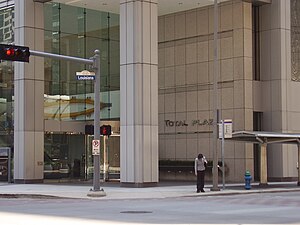
Total Plaza
Skyscraper in downtown Houston Texas
Distance: Approx. 220 meters
Latitude and longitude: 29.7565,-95.3685
Total Plaza (formerly the Entex Building, Louisiana Place, and United Gas Building) is a tower in Downtown Houston, Texas, one block from the Allen Center complex. The building, managed by Brookfield Properties, opened in 1971. The 35-story building, designed by the architect Lloyd, Morgan & Jones, was renovated in 1981 and 1996, and features a mirror-finished reflective glass on its exterior.

Humble Oil Building
Historic building in Houston, Texas, U.S.
Distance: Approx. 202 meters
Latitude and longitude: 29.75527778,-95.36694444
The Humble Oil Building, is a historic office building, designed in the Italian Renaissance architecture style, located at 1212 Main Street in Houston, Texas and listed on the National Register of Historic Places. It was constructed by Humble Oil and Refining Company in 1921. The tower section was added on to the building in 1936.

Bender Hotel (Houston)
Former hotel in Houston, Texas
Distance: Approx. 215 meters
Latitude and longitude: 29.758,-95.3644
The Bender Hotel was a ten-story building in Downtown Houston on Main Street at the corner of Walker. It was later known as the San Jacinto Hotel, and later repurposed as an office building before it was demolished.

City National Bank Building (Houston)
Historic building in Houston, Texas, U.S.
Distance: Approx. 193 meters
Latitude and longitude: 29.75688889,-95.36430556
The City National Bank Building, located at 1001 McKinney Avenue in Houston, Texas, was listed on the National Register of Historic Places on April 3, 2000.
Kirby Lofts
Building in Houston, Texas
Distance: Approx. 181 meters
Latitude and longitude: 29.75722222,-95.36444444
The Kirby Lofts is an 11-story building at 917 Main Street in Downtown Houston, Texas, currently consisting of apartments with retail on the ground floor, originally built in 1926 and designed by Alfred C. Finn, a noted Houston-based architect.
Weather in this IP's area
overcast clouds
12 Celsius
12 Celsius
11 Celsius
13 Celsius
1025 hPa
91 %
1025 hPa
1022 hPa
10000 meters
2.68 m/s
4.47 m/s
3 degree
100 %

