216.215.112.207 - IP Lookup: Free IP Address Lookup, Postal Code Lookup, IP Location Lookup, IP ASN, Public IP
Country:
 USA
USARegion:
City:
Location:
Time Zone:
Postal Code:
ISP:
ASN:
language:
User-Agent:
Proxy IP:
Blacklist:
IP information under different IP Channel
ip-api
Country
Region
City
ASN
Time Zone
ISP
Blacklist
Proxy
Latitude
Longitude
Postal
Route
db-ip
Country
Region
City
ASN
Time Zone
ISP
Blacklist
Proxy
Latitude
Longitude
Postal
Route
IPinfo
Country
Region
City
ASN
Time Zone
ISP
Blacklist
Proxy
Latitude
Longitude
Postal
Route
IP2Location
216.215.112.207Country
usRegion
texas
City
rosenberg
Time Zone
America/Chicago
ISP
Language
User-Agent
Latitude
Longitude
Postal
ipdata
Country
Region
City
ASN
Time Zone
ISP
Blacklist
Proxy
Latitude
Longitude
Postal
Route
Popular places and events near this IP address

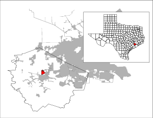
Fort Bend County, Texas
County in Texas, United States
Distance: Approx. 8594 meters
Latitude and longitude: 29.53,-95.77
Fort Bend County is a county located in the U.S. state of Texas. The county was founded in 1837 and organized the next year. It is named for a blockhouse at a bend of the Brazos River.

Beasley, Texas
City in Texas, United States
Distance: Approx. 8771 meters
Latitude and longitude: 29.49638889,-95.91722222
Beasley is a city in Fort Bend County, Texas, United States, within the Houston–Sugar Land metropolitan area. The city's population was 641 at the 2010 census, up from 590 at the 2000 census. State Highway Loop 540 goes straight through the city from the northeast to the southwest while U.S. Route 59, the Southwest Freeway, passes to the south of Beasley.
Cumings, Texas
Census-designated place in Texas, United States
Distance: Approx. 5455 meters
Latitude and longitude: 29.57361111,-95.80333333
Cumings is an unincorporated community and census-designated place (CDP) in Fort Bend County, Texas, United States. The population was 2,207 at the 2020 census, significantly up from 981 at the 2010 census.

Pleak, Texas
Village in Texas, United States
Distance: Approx. 8826 meters
Latitude and longitude: 29.48416667,-95.81
Pleak is a village in Fort Bend County, Texas, United States, within the Houston–Sugar Land–Baytown metropolitan area. It is on Texas State Highway 36, south of Rosenberg. Its population was 971 at the 2020 census.

Rosenberg, Texas
City in Texas, United States
Distance: Approx. 4804 meters
Latitude and longitude: 29.5525,-95.805
Rosenberg is a city in the U.S. state of Texas, within the Houston–The Woodlands–Sugar Land metropolitan area and Fort Bend County. Rosenberg was named for Henry Von Rosenberg, who emigrated to Texas from Switzerland in 1843. Von Rosenberg was an important figure in the settlement of Fort Bend County and the Gulf Coast region.

John and Randolph Foster High School
Public school in Texas, United States
Distance: Approx. 9279 meters
Latitude and longitude: 29.62714,-95.81012
John and Randolph Foster High School is a secondary school located in unincorporated Fort Bend County, Texas, United States, north of Rosenberg. The school is part of the Lamar Consolidated Independent School District. It opened in 2001, with the intent of relieving the student population at nearby B.F. Terry High School and Lamar Consolidated High School.

Lamar Consolidated Independent School District
School district in Texas, United States
Distance: Approx. 6633 meters
Latitude and longitude: 29.5578,-95.7863
Lamar Consolidated Independent School District, also Lamar Consolidated ISD, Lamar CISD or LCISD, is a public school district in the U.S. state of Texas within the Houston–Sugar Land–Metropolitan Area. Lamar CISD includes almost 43 percent of Fort Bend County, covering the cities of Richmond, Rosenberg, Kendleton, Simonton, Thompsons, Weston Lakes, a very small portion of Sugar Land, most of Fulshear, most of the village of Pleak, the census-designated place of Cumings, a portion of the Pecan Grove CDP, the community of Lakemont, the unincorporated areas of Booth, Crabb, Foster, and Powell Point, and most of the unincorporated rural areas (including areas in Sugar Land's extraterritorial jurisdiction (ETJ) in central Fort Bend County. Lamar CISD enrolls over 27,000 students and is the fastest-growing district in Fort Bend County.

KQUE (AM)
Radio station in Rosenberg-Richmond, Texas
Distance: Approx. 6901 meters
Latitude and longitude: 29.55277778,-95.78333333
KQUE (980 AM), is a Spanish language Christian radio AM station, with an FM relay translator, in the Houston, Texas, metropolitan area.

Rosenberg Railroad Museum
The history of the rosengberg railroad museum
Distance: Approx. 4631 meters
Latitude and longitude: 29.5605,-95.8075
The Rosenberg Railroad Museum is a non-profit organization located at 1921 Avenue F, Rosenberg, Texas and maintains exhibits relating to local railroad history.

Lamar Consolidated High School
Public school in Texas, United States
Distance: Approx. 7322 meters
Latitude and longitude: 29.56055556,-95.77944444
Lamar Consolidated High School is a grades 9–12 school located in Rosenberg, Texas, United States. The school, which serves the City of Richmond, parts of Rosenberg, and unincorporated areas of Fort Bend County, is a part of the Lamar Consolidated Independent School District (LCISD). All areas served by LCHS are within the Houston metropolitan area.

B. F. Terry High School
Public high school in Rosenberg, Texas, USA
Distance: Approx. 7958 meters
Latitude and longitude: 29.54444444,-95.77305556
B. F. Terry High School is located in Rosenberg, Texas, United States, and is part of the Lamar Consolidated Independent School District. Terry serves all of Beasley, and serves parts of Rosenberg, and the unincorporated communities of Booth and Crabb. It formerly served most of Pleak.
Fort Bend Epicenter
Indoor arena in Rosenberg, Texas
Distance: Approx. 3258 meters
Latitude and longitude: 29.53233,-95.831139
The Fort Bend Epicenter (sometimes stylized as EpiCenter) is a 230,000 square foot (21,368 m2) multi-purpose arena and event space in the Houston suburb of Rosenberg, Texas. It is the home venue of LOVB Houston in LOVB Pro. The facility comprises an 8,600-seat arena, conference rooms, a multi-purpose area, and an outdoor pavilion.
Weather in this IP's area
overcast clouds
27 Celsius
29 Celsius
26 Celsius
28 Celsius
1020 hPa
60 %
1020 hPa
1016 hPa
10000 meters
2.68 m/s
6.26 m/s
163 degree
100 %