216.215.111.192 - IP Lookup: Free IP Address Lookup, Postal Code Lookup, IP Location Lookup, IP ASN, Public IP
Country:
 USA
USARegion:
City:
Location:
Time Zone:
Postal Code:
ISP:
ASN:
language:
User-Agent:
Proxy IP:
Blacklist:
IP information under different IP Channel
ip-api
Country
Region
City
ASN
Time Zone
ISP
Blacklist
Proxy
Latitude
Longitude
Postal
Route
db-ip
Country
Region
City
ASN
Time Zone
ISP
Blacklist
Proxy
Latitude
Longitude
Postal
Route
IPinfo
Country
Region
City
ASN
Time Zone
ISP
Blacklist
Proxy
Latitude
Longitude
Postal
Route
IP2Location
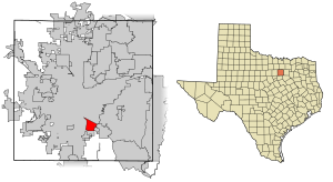
216.215.111.192Country
usRegion
texas
City
fort worth
Time Zone
America/Chicago
ISP
Language
User-Agent
Latitude
Longitude
Postal
ipdata
Country
Region
City
ASN
Time Zone
ISP
Blacklist
Proxy
Latitude
Longitude
Postal
Route
Popular places and events near this IP address
Forest Hill, Texas
City in Texas, United States
Distance: Approx. 2161 meters
Latitude and longitude: 32.66222222,-97.25722222
Forest Hill is a suburb of Fort Worth in Tarrant County, Texas, United States. The population was 13,955 at the 2020 census.

Texas Wesleyan University
Methodist university in Fort Worth, Texas, US
Distance: Approx. 6011 meters
Latitude and longitude: 32.733,-97.28
Texas Wesleyan University is a private Methodist university in Fort Worth, Texas. It was founded in 1890 by the Methodist Episcopal Church, South. The main campus is located in the Polytechnic Heights neighborhood of Fort Worth.
Lon Goldstein Field
Baseball park in Fort Worth, Texas, US
Distance: Approx. 2588 meters
Latitude and longitude: 32.669,-97.289
Lon Goldstein Field is an approximately 2,000 seat baseball park located in Fort Worth, Texas. The ballpark was opened in 1975, as part of the athletic field for the Fort Worth Independent School District. The ballpark is bounded by Joe B. Rushing Road (north, left field), beyond which is Rolling Hills Park; C.A. Roberson Boulevard (west, third base), across which is Tarrant County College South Campus; athletic facilities and the football stadium, and then Interstate Highway 20 (south, first base); and soccer fields and Wichita Street (east, right field).
O. D. Wyatt High School
Public school in Texas, United States
Distance: Approx. 2755 meters
Latitude and longitude: 32.682689,-97.294284
Oscar Dean Wyatt High School is a secondary school in Fort Worth, Texas, United States. The school is located at 2400 East Seminary Drive. The school is a part of the Fort Worth Independent School District.
Herman Clark Stadium
Multi-use stadium in Fort Worth, Texas
Distance: Approx. 2227 meters
Latitude and longitude: 32.66754,-97.283099
Herman Clark Stadium Paul Galvan Field is a 12,000-capacity multi-use stadium in Fort Worth, Texas. The stadium is mostly used for High school football where it hosts teams from the Fort Worth Independent School District but is also used for track & field contests and soccer matches. The playing surface is artificial turf and there is no video scoreboard.

Masonic Home Independent School District
School district in Texas
Distance: Approx. 3438 meters
Latitude and longitude: 32.70888889,-97.27944444
The Masonic Home and School of Texas was a home for widows and orphans in what is now Fort Worth, Texas from 1889 to 2005. The first superintendent was Dr. Frank Rainey of Austin, Texas.
Paul Laurence Dunbar High School (Fort Worth, Texas)
Public high school in Fort Worth, Texas, United States
Distance: Approx. 5443 meters
Latitude and longitude: 32.7262427,-97.2444584
Paul Laurence Dunbar High School is a comprehensive high school in the Stop Six neighborhood of Fort Worth, Texas, United States. Named for the dialectical poet Paul Laurence Dunbar, the school strives to educate the majority African-American community it serves.

Federal Medical Center, Fort Worth
U.S. medical prison in Texas
Distance: Approx. 2110 meters
Latitude and longitude: 32.67972222,-97.2875
The Federal Medical Center (FMC) Fort Worth is an administrative-security United States federal prison in Fort Worth, Texas, for male inmates of all security levels with special medical and mental health needs. It is operated by the Federal Bureau of Prisons, a division of the United States Department of Justice. Originally opening as a Federal Correctional Institution in 1971, the institution was converted to a Federal Medical Center in 1994.
La Gran Plaza de Fort Worth
Shopping mall in Fort Worth, Texas
Distance: Approx. 5748 meters
Latitude and longitude: 32.686,-97.326
La Gran Plaza de Fort Worth is a Hispanic-themed shopping mall in Fort Worth, Texas. Opened in 1962 as Seminary South and later known as Fort Worth Town Center, it was reinvented as a center catering to largely Hispanic clientele after losing most of its major stores. Major tenants include Burlington, Ross Dress for Less, Bealls Clearance Center, and El Mercado.

Fort Worth missing trio
Unsolved 1974 disappearance of three girls in Texas
Distance: Approx. 5686 meters
Latitude and longitude: 32.68638889,-97.32527778
The Fort Worth Missing Trio refers to an unsolved missing persons case in which three girls – Mary Rachel Trlica, Lisa Renee Wilson, and Julie Ann Moseley – went missing while shopping at the Seminary South Shopping Center in Fort Worth, Texas, on December 23, 1974. The car that the girls had been driving was left behind in the parking lot at the mall; the girls themselves have not been seen since. The case shocked the Fort Worth community and left the families of the girls to adjust to life without their children.
Maudrie M. Walton Elementary School
Public school in Texas, United States
Distance: Approx. 5638 meters
Latitude and longitude: 32.7214,-97.2295
Maudrie M. Walton Elementary School is a public elementary school in Stop Six, Fort Worth, Texas. It is a part of the Fort Worth Independent School District. In 2003 PBS released a documentary called A Tale of Two Schools which features the school's reputational growth and educational methods used from fall 2000 to spring 2001, along that with those of R. H. Bearden Elementary School in Tallahatchie County, Mississippi.

Lake Arlington (Texas)
Lake in Texas, United States
Distance: Approx. 5398 meters
Latitude and longitude: 32.70333333,-97.21416667
Lake Arlington is a lake located in West Arlington, Texas. The lake is situated east of Interstate 820, and directly west of the city of Dalworthington Gardens. It is located on Village Creek.
Weather in this IP's area
mist
6 Celsius
3 Celsius
4 Celsius
6 Celsius
1027 hPa
90 %
1027 hPa
1002 hPa
3219 meters
4.12 m/s
40 degree
100 %