216.201.246.89 - IP Lookup: Free IP Address Lookup, Postal Code Lookup, IP Location Lookup, IP ASN, Public IP
Country:
 USA
USARegion:
City:
Location:
Time Zone:
Postal Code:
ISP:
ASN:
language:
User-Agent:
Proxy IP:
Blacklist:
IP information under different IP Channel
ip-api
Country
Region
City
ASN
Time Zone
ISP
Blacklist
Proxy
Latitude
Longitude
Postal
Route
db-ip
Country
Region
City
ASN
Time Zone
ISP
Blacklist
Proxy
Latitude
Longitude
Postal
Route
IPinfo
Country
Region
City
ASN
Time Zone
ISP
Blacklist
Proxy
Latitude
Longitude
Postal
Route
IP2Location
216.201.246.89Country
usRegion
texas
City
houston
Time Zone
America/Chicago
ISP
Language
User-Agent
Latitude
Longitude
Postal
ipdata
Country
Region
City
ASN
Time Zone
ISP
Blacklist
Proxy
Latitude
Longitude
Postal
Route
Popular places and events near this IP address
Fifth Street, Texas
Census-designated place in Texas, United States
Distance: Approx. 2978 meters
Latitude and longitude: 29.59805556,-95.55111111
Fifth Street is a census-designated place (CDP) located in the extraterritorial jurisdiction of Stafford within Fort Bend County, Texas, United States. The population was 2,284 at the 2020 census. Fifth Street is within the ZIP code 77477.
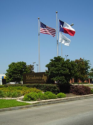
Meadows Place, Texas
City in Texas, United States
Distance: Approx. 3878 meters
Latitude and longitude: 29.64972222,-95.58861111
Meadows Place is a city located in Fort Bend County in the U.S. state of Texas within the Houston–Sugar Land–Baytown metropolitan area. As of the 2020 U.S. Census, the city population was 4,767. Meadows Place was part of Stafford's extraterritorial jurisdiction prior to incorporation on November 14, 1983.

Sugar Land, Texas
City in the United States
Distance: Approx. 5526 meters
Latitude and longitude: 29.59944444,-95.61416667
Sugar Land (sometimes incorrectly spelled as Sugarland) is the largest city in Fort Bend County, Texas, United States, located in the southwestern part of the Houston–The Woodlands–Sugar Land metropolitan area. Located about 19 miles (31 km) southwest of downtown Houston, Sugar Land is a populous suburban municipality centered around the junction of Texas State Highway 6 and Interstate 69/U.S. Route 59. Beginning in the 19th century, the present-day Sugar Land area was home to a large sugar plantation situated in the fertile floodplain of the Brazos River.

Missouri City, Texas
City in Texas, United States
Distance: Approx. 2536 meters
Latitude and longitude: 29.61861111,-95.53777778
Missouri City is a city in the U.S. state of Texas, within the Houston–The Woodlands–Sugar Land metropolitan area. The city is mostly in Fort Bend County, with a small portion in Harris County. As of the 2020 census, the city had a population of 74,259, an increase over the figure of 67,358 tabulated in 2010.

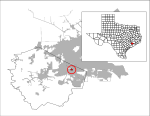
Stafford, Texas
City in Texas, United States
Distance: Approx. 187 meters
Latitude and longitude: 29.62416667,-95.56333333
Stafford is a city in the U.S. state of Texas, in the Houston–The Woodlands–Sugar Land metropolitan area. The city is mostly in Fort Bend County, with a small part in Harris County. As of the 2020 census, Stafford's population was 17,666, down from 17,693 at the 2010 census.

Dulles High School (Sugar Land, Texas)
Public school in Sugar Land, Texas, United States
Distance: Approx. 2006 meters
Latitude and longitude: 29.62037,-95.58418
John Foster Dulles High School, more commonly known as Dulles High School, is a high school in Sugar Land, Texas. It was the first site purchase and new build, in the 1950s, of the newly formed Fort Bend Independent School District, which held its first graduation in 1960. The first class to graduate from Dulles itself was 1962.

Thurgood Marshall High School (Texas)
Public high school in Missouri City, Texas, United States
Distance: Approx. 4150 meters
Latitude and longitude: 29.611246,-95.522718
Thurgood Marshall High School is a public high school located in Missouri City, Texas and is a part of the Fort Bend Independent School District. Marshall, serving grades 9 through 12, serves sections of Missouri City and a portion of the extraterritorial jurisdiction of Stafford, including sections of Fifth Street. A small portion of the City of Houston is in the school's boundary.

Quail Valley (Missouri City, Texas)
Master-Planned Community in Missouri City, Texas
Distance: Approx. 5893 meters
Latitude and longitude: 29.57194444,-95.54555556
Quail Valley is a neighborhood dating from 1969 of Missouri City (a southwest suburb of Houston), in Fort Bend County, Texas, United States. The homeowners association is the Quail Valley Fund.

Forum Park, Houston
Distance: Approx. 5353 meters
Latitude and longitude: 29.67,-95.555
Forum Park is a community in Houston, Texas. It is bounded by Texas State Highway Beltway 8, U.S. Route 59 (Southwest Freeway), and Bissonnet Road. A portion of the community resides in the Greater Sharpstown district.

Westwood (subdivision), Houston
Distance: Approx. 6156 meters
Latitude and longitude: 29.6775,-95.557
Westwood is a residential subdivision in Southwest Houston, Texas. The subdivision is bounded by the 610 Loop, the Union Pacific railroad tracks, Stella Link Road, and Willowbend Boulevard. It has about 800 houses.

Fort Bend Christian Academy
Private, co-educational, non-profit school in the United States
Distance: Approx. 5064 meters
Latitude and longitude: 29.6301,-95.6152
Fort Bend Christian Academy (FBCA) is a private PK-12 Christian school with two campuses in Sugar Land, Texas in the Houston metropolitan area. With two campuses, the North Campus houses upper school (9th - 12th Grade) while the South Campus houses lower school (PreK - 4th Grade) and middle school (5th - 8th Grade). FBCA pursues a mission "to equip students to thrive spiritually, academically, socially, emotionally, and physically" through weekly chapel, maintaining a 10:1 student-to-teacher ratio in the upper school and providing a wide variety of honors and AP courses.

St. Joseph Syro Malabar Forane Catholic Church
Church in Texas, United States
Distance: Approx. 2000 meters
Latitude and longitude: 29.61375,-95.54555556
The St. Joseph Syro Malabar Forane Catholic Church is a Syro-Malabar Catholic Forane Parish in Missouri City, Texas serving the community of Houston. It is a Forane Parish for the Syro-Malabar Catholic Eparchy of St.
Weather in this IP's area
broken clouds
25 Celsius
26 Celsius
24 Celsius
26 Celsius
1020 hPa
74 %
1020 hPa
1017 hPa
10000 meters
2.06 m/s
210 degree
75 %