216.201.217.67 - IP Lookup: Free IP Address Lookup, Postal Code Lookup, IP Location Lookup, IP ASN, Public IP
Country:
 USA
USARegion:
City:
Location:
Time Zone:
Postal Code:
ISP:
ASN:
language:
User-Agent:
Proxy IP:
Blacklist:
IP information under different IP Channel
ip-api
Country
Region
City
ASN
Time Zone
ISP
Blacklist
Proxy
Latitude
Longitude
Postal
Route
db-ip
Country
Region
City
ASN
Time Zone
ISP
Blacklist
Proxy
Latitude
Longitude
Postal
Route
IPinfo
Country
Region
City
ASN
Time Zone
ISP
Blacklist
Proxy
Latitude
Longitude
Postal
Route
IP2Location
216.201.217.67Country
usRegion
texas
City
austin
Time Zone
America/Chicago
ISP
Language
User-Agent
Latitude
Longitude
Postal
ipdata
Country
Region
City
ASN
Time Zone
ISP
Blacklist
Proxy
Latitude
Longitude
Postal
Route
Popular places and events near this IP address

KVRX
Student radio station at the University of Texas at Austin
Distance: Approx. 1321 meters
Latitude and longitude: 30.267,-97.674
KVRX (91.7 FM) is a student-run radio station owned by the University of Texas in Austin, Texas, with an effective radiated power of 3,000 watts. KVRX's studios are based in the Hearst Student Media Building on the university campus, while its transmitter is located in East Austin. The university shares the license for 91.7 with KOOP, a community radio station based in Austin.
KOOP (FM)
Community radio station in Hornsby–Austin, Texas
Distance: Approx. 1296 meters
Latitude and longitude: 30.2669,-97.6744
KOOP (91.7 FM) (pronounced 'co-op') is a noncommercial community radio station owned and operated by its members and staffed by volunteers. The station broadcasts in Austin, Texas on 91.7 MHz at an effective radiated power of 3 kilowatts and is licensed to Texas Educational Broadcasting Co-operative, Inc., a nonprofit organization (doing business as KOOP Radio, previously Austin Co-op Radio). The station was assigned the KOOP call letters by the Federal Communications Commission on October 27, 1993.

Mueller Community
Neighborhood in Austin, Texas, United States
Distance: Approx. 2422 meters
Latitude and longitude: 30.28944444,-97.70263611
Mueller is a 711-acre (288 ha) Planned Unit Development (PUD) in the east-central portion of the city of Austin, Texas, United States. The project is in the process of long-term development on the former site of the Robert Mueller Municipal Airport, which was closed in 1999 upon the opening of Austin–Bergstrom International Airport in southeast Austin, itself a civilian adaptation of Bergstrom Air Force Base after its closure in the early 1990s. Mueller is intended to be a pedestrian-oriented, interactive mixed-use community and a model for responsible urban planning and development.
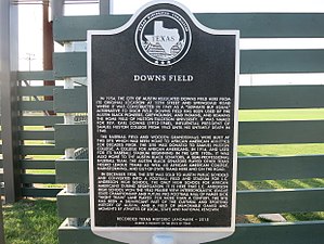
Downs Field
Baseball venue in Austin, Texas, US
Distance: Approx. 2319 meters
Latitude and longitude: 30.276052,-97.709442
Downs Field is a baseball venue located in Austin, Texas, and the home of the Huston–Tillotson University Rams baseball team. Downs Field was once the home of the Austin Black Senators and also was the home ballpark of Samuel Huston College before it combined with Tillotson College as one unified college in 1952. Some notable names that have taken the field at Downs Field were Satchel Paige, Willie Wells, Smokey Joe Williams, Willie Mays, and Buck O'Neil.
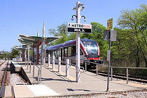
MLK Jr. station (CapMetro Rail)
Hybrid rail station in Austin, Texas
Distance: Approx. 2356 meters
Latitude and longitude: 30.27974,-97.708913
MLK Jr. station is a CapMetro Rail hybrid rail station in Austin, Texas. It was built with a musical theme in mind and is located in East Austin at the corner of Martin Luther King Jr.

Eastside High School (Austin, Texas)
High school in Austin, Texas
Distance: Approx. 2303 meters
Latitude and longitude: 30.2687,-97.7088
Eastside Early College High School (formerly Johnston High School, Eastside Memorial High School) is located in Austin, Texas. It is a part of the Austin Independent School District (AISD).
Albert Sidney Johnston High School
Distance: Approx. 1764 meters
Latitude and longitude: 30.25805556,-97.68138889
Albert Sidney Johnston High School served as a comprehensive, coeducational high school in the Austin Independent School District from 1960 to 2008. Located in Austin, Texas, the school was named after General Albert Sidney Johnston, who served as Secretary of War for the Republic of Texas and as a brigadier general for the Texian Army of the Republic of Texas, the United States Army, and the Confederate States Army. From its inception in 1960, Johnston High School was well known for a wide variety of vocational and technical programs that prepared students for work in such fields as cosmetology, printing, auto mechanics, industry and business.

Rosewood Park (Austin, Texas)
Distance: Approx. 2761 meters
Latitude and longitude: 30.272153,-97.7141712
Rosewood Neighborhood Park is a public park in East Austin, Texas. The park features tennis courts, playscapes, swimming pool, splash pad, as well as the Delores Duffie Recreation Center and the Doris "Dorie" Miller Auditorium. Combined, they comprise a 31,500 square feet facility with a gymnasium.

Austin Peace Academy
Islamic school in Austin, Texas, United States
Distance: Approx. 2907 meters
Latitude and longitude: 30.2995891,-97.6867624
Austin Peace Academy (APA) is an Islamic school in Austin, Texas, serving pre-kindergarten through grade 12. As of 2016, its students originate from 19 nationalities. It opened in 1997 in West Campus, housing pre-kindergarten, and moved to current location in 1999.

Anderson Stadium
Historic football stadium in east Austin, Texas
Distance: Approx. 2387 meters
Latitude and longitude: 30.27,-97.71
Anderson Stadium, also known as Yellow Jacket Stadium, is a historic football and track and field facility in East Austin, Texas. The stadium was built in 1953 as the football facility on what was then the campus of L.C. Anderson High School, Austin's only public high school open to African Americans under racial segregation. Closed in 1971 as part of a school integration plan and restored in the 1990s, Anderson Stadium was added to the National Register of Historic Places in 2022.
Nixta Taqueria
Restaurant in Austin, Texas, U.S.
Distance: Approx. 2675 meters
Latitude and longitude: 30.27499,-97.71327
Nixta Taqueria is a restaurant in Austin, Texas. The business earned co-owner and chef Edgar Rico a James Beard Foundation Award in the Emerging Chef category.
Birdie's
Restaurant in Austin, Texas
Distance: Approx. 1864 meters
Latitude and longitude: 30.2764,-97.7046
Birdie's is a restaurant in Austin, Texas. In 2023 it was named Food & Wine's Restaurant of the Year. The New York Times' Eric Asimov in 2024 called it "one of the most acclaimed restaurants in the country".
Weather in this IP's area
mist
13 Celsius
12 Celsius
12 Celsius
14 Celsius
1021 hPa
82 %
1021 hPa
999 hPa
9656 meters
5.66 m/s
10 degree
100 %