216.201.214.107 - IP Lookup: Free IP Address Lookup, Postal Code Lookup, IP Location Lookup, IP ASN, Public IP
Country:
 USA
USARegion:
City:
Location:
Time Zone:
Postal Code:
ISP:
ASN:
language:
User-Agent:
Proxy IP:
Blacklist:
IP information under different IP Channel
ip-api
Country
Region
City
ASN
Time Zone
ISP
Blacklist
Proxy
Latitude
Longitude
Postal
Route
db-ip
Country
Region
City
ASN
Time Zone
ISP
Blacklist
Proxy
Latitude
Longitude
Postal
Route
IPinfo
Country
Region
City
ASN
Time Zone
ISP
Blacklist
Proxy
Latitude
Longitude
Postal
Route
IP2Location
216.201.214.107Country
usRegion
texas
City
fort worth
Time Zone
America/Chicago
ISP
Language
User-Agent
Latitude
Longitude
Postal
ipdata
Country
Region
City
ASN
Time Zone
ISP
Blacklist
Proxy
Latitude
Longitude
Postal
Route
Popular places and events near this IP address

Blue Mound, Texas
City in Texas, United States
Distance: Approx. 4509 meters
Latitude and longitude: 32.85416667,-97.33833333
Blue Mound is a city in Tarrant County, Texas, United States. The population was 2,393 as of the 2020 census.
Watauga, Texas
City in Texas, United States
Distance: Approx. 4110 meters
Latitude and longitude: 32.87138889,-97.24916667
Watauga () is a city in Tarrant County, Texas, United States, and a suburb of Fort Worth. The population was 23,650 at the 2020 census. The city's businesses and retail markets are generally located on Highway 377.

Fossil Ridge High School (Fort Worth, Texas)
American public high school
Distance: Approx. 3863 meters
Latitude and longitude: 32.89305556,-97.29527778
Fossil Ridge High School (FRHS) is an American public high school located in northeast Fort Worth, Texas. It is the second high school inside the Keller Independent School District. Most nearby schools such as Fossil Hill Middle School and Vista Ridge Middle School graduates feed into Fossil Ridge.
Haltom High School
School in Haltom City, Texas, United States
Distance: Approx. 1533 meters
Latitude and longitude: 32.848257,-97.27957
Haltom High School is a grade 9–12 high school located in Haltom City, Texas.
Paw Paw Formation
Geological formation in Texas
Distance: Approx. 4695 meters
Latitude and longitude: 32.9,-97.3
The Paw Paw Formation is a geological formation in Texas whose strata date back to the late Albian stage of the Early Cretaceous. Dinosaur remains are among the fossils that have been recovered from the formation.
Maple, Dallas
Distance: Approx. 1815 meters
Latitude and longitude: 32.8722,-97.2797
Maple Lawn, or Maple for short is an area in North Dallas, Texas, United States, which is home to government owned section 8 projects. The area has long been home to a largely African American and Hispanic community. Maple Avenue is the main road through the area, although the Maple Lawn area is unofficially the area bound to the West/Southwest of Harry Hines Boulevard, to the East by the Dallas North Tollway, to the North/Northeast by Lemmon Avenue, and to the Northwest by Mockingbird Lane.
Bethesda Christian School (Fort Worth, Texas)
School in Fort Worth, Texas, USA
Distance: Approx. 3075 meters
Latitude and longitude: 32.831,-97.289
Bethesda Christian School is a private K-12 Christian school located in Fort Worth, Texas. Bethesda Christian School started in 1980. The school started as a daycare known as the Wisdom Day Care in 1977.
North Texas Intermediate Sanction Facility
Distance: Approx. 4978 meters
Latitude and longitude: 32.872351,-97.341054
The North Texas Intermediate Sanction Facility (NTISF (GEO Group acronym) or XL (TDCJ acronym)) was a privately operated prison facility located in northern Fort Worth, Texas. It was operated by the GEO Group on behalf of the Texas Department of Criminal Justice. The facility was on the east side of Blue Mound Road, about 1 mile (1.6 km) south of Interstate 820 and north of Downtown Fort Worth.
Silver Sage, Fort Worth, Texas
Neighborhood in Fort Worth, Texas
Distance: Approx. 566 meters
Latitude and longitude: 32.8609,-97.285
Silver Sage is an area/community located in north-east Fort Worth, Texas, in an area around Silver Sage park on Silver Sage drive. The community is actually composed of several separate neighborhoods, but people often refer it as one big neighborhood. Silver Sage is a lower to middle class community populated mostly by African-Americans, Whites, Hispanics, and Asians.

National Weather Service Fort Worth, Texas
NWS Forecast Office serving Dallas-Fort Worth, north central Texas
Distance: Approx. 2750 meters
Latitude and longitude: 32.83490194,-97.29870083
The National Weather Service Fort Worth, Texas (NWS Fort Worth) is a local weather forecast office of the National Weather Service responsible for monitoring weather conditions for 46 counties in north central Texas, including the Dallas-Fort Worth Metro Area (the Metroplex) and Waco, Texas.
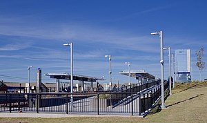
North Richland Hills/Iron Horse station
Distance: Approx. 4083 meters
Latitude and longitude: 32.842736,-97.251031
North Richland Hills/Iron Horse station is a TEXRail commuter rail station in North Richland Hills, Texas.

Mercantile Center station
Distance: Approx. 4384 meters
Latitude and longitude: 32.8193,-97.2934
Mercantile Center station is a TEXRail commuter rail station in Fort Worth, Texas.
Weather in this IP's area
mist
6 Celsius
2 Celsius
4 Celsius
6 Celsius
1027 hPa
89 %
1027 hPa
1002 hPa
2816 meters
5.14 m/s
60 degree
100 %