216.201.209.182 - IP Lookup: Free IP Address Lookup, Postal Code Lookup, IP Location Lookup, IP ASN, Public IP
Country:
Region:
City:
Location:
Time Zone:
Postal Code:
IP information under different IP Channel
ip-api
Country
Region
City
ASN
Time Zone
ISP
Blacklist
Proxy
Latitude
Longitude
Postal
Route
Luminati
Country
Region
tx
City
dallas
ASN
Time Zone
America/Chicago
ISP
LOGIXCOMM-AS
Latitude
Longitude
Postal
IPinfo
Country
Region
City
ASN
Time Zone
ISP
Blacklist
Proxy
Latitude
Longitude
Postal
Route
IP2Location
216.201.209.182Country
Region
texas
City
houston
Time Zone
America/Chicago
ISP
Language
User-Agent
Latitude
Longitude
Postal
db-ip
Country
Region
City
ASN
Time Zone
ISP
Blacklist
Proxy
Latitude
Longitude
Postal
Route
ipdata
Country
Region
City
ASN
Time Zone
ISP
Blacklist
Proxy
Latitude
Longitude
Postal
Route
Popular places and events near this IP address

Rothko Chapel
United States historic place
Distance: Approx. 224 meters
Latitude and longitude: 29.7375,-95.39611111
The Rothko Chapel is a non-denominational chapel in Houston, Texas, founded by John and Dominique de Menil. The interior serves not only as a chapel, but also as a major work of modern art: on its walls are fourteen paintings by Mark Rothko in varying hues of black. The shape of the building—an octagon inscribed in a Greek cross—and the design of the chapel were largely influenced by the artist.
University of St. Thomas (Texas)
Catholic university in Houston, Texas
Distance: Approx. 97 meters
Latitude and longitude: 29.7367,-95.3932
The University of St. Thomas (UST or St. Thomas) is a private Catholic university in Houston, Texas.
Menil Collection
Art museum in Houston, Texas, US
Distance: Approx. 465 meters
Latitude and longitude: 29.73722222,-95.39861111
The Menil Collection, located in Houston, Texas, refers either to a museum that houses the art collection of founders John de Menil and Dominique de Menil, or to the collection itself of paintings, sculptures, prints, drawings, photographs and rare books. While the bulk of the collection is made up of a once-private collection, Menil Foundation, Inc. is a tax-exempt, nonprofit, public charity corporation formed under Section 501(c)3 of the Internal Revenue Code.

Montrose, Houston
Neighborhood of Houston in Harris, Texas, United States
Distance: Approx. 396 meters
Latitude and longitude: 29.74,-95.391
Montrose is a neighborhood located in west-central Houston, Texas, United States. Montrose is a 7.5-square-mile (19 km2) area roughly bounded by Interstate 69/U.S. Highway 59 to the south, Allen Parkway to the north, South Shepherd Drive to the west, and Taft to Fairview to Bagby to Highway 59 to Main to the east. The area is also referred to as Neartown or Neartown / Montrose.

Chapel of St. Basil
Distance: Approx. 126 meters
Latitude and longitude: 29.7384,-95.3932
The Chapel of St. Basil is a chapel on the campus of the University of St. Thomas in Houston, TX, designed by Philip Johnson in 1997.

Link–Lee House
Historic house in Texas, United States
Distance: Approx. 237 meters
Latitude and longitude: 29.73777778,-95.39138889
The Link–Lee House is a large historic home located in Montrose in central Houston, Harris County, in the U.S. state of Texas. It is currently serving as the executive office of the University of St. Thomas.

Annunciation Greek Orthodox Cathedral (Houston)
Church in the United States
Distance: Approx. 403 meters
Latitude and longitude: 29.740842,-95.3925179
Annunciation Greek Orthodox Cathedral is the spiritual home of the largest Eastern Orthodox parish in Houston, Texas. It is located in Montrose and Neartown. The cathedral was built from 1950 to 1952 by the Greek community of Houston.
Isolated Mass/Circumflex (Number 2)
Sculpture in Houston, Texas, U.S.
Distance: Approx. 471 meters
Latitude and longitude: 29.73765,-95.39866
Isolated Mass/Circumflex (Number 2), stylized as Isolated Mass/Circumflex (#2), is an outdoor 1968–1978 sculpture by Michael Heizer, installed outside the Menil Collection in Houston, Texas, United States. The work is one of several by Heizer in the Menil Collection.

Bygones (sculpture)
Sculpture in Houston, Texas, U.S.
Distance: Approx. 324 meters
Latitude and longitude: 29.737586,-95.397145
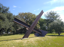
Bygones is an outdoor 1976 sculpture by Mark di Suvero, installed at Houston's Menil Collection, in the U.S. state of Texas. The abstract, geometric sculpture is made of Cor-ten beams and a milled steel plate, and measures 25 ft. 11 in.
Sand Mountain Coffee House
Music venue in Houston, Texas
Distance: Approx. 347 meters
Latitude and longitude: 29.7343,-95.3942
Sand Mountain Coffee House was a venue and home to Houston folk musicians from 1965 to 1977. Guy Clark, Townes Van Zandt, Jerry Jeff Walker, and Don Sanders were notable artists who wrote, performed, and sometimes lived at the coffee house.

Charmstone (sculpture)
Sculpture in Houston, Texas, U.S.
Distance: Approx. 454 meters
Latitude and longitude: 29.737485,-95.398496
Charmstone is a stone pendant sculpture by Michael Heizer, installed outside the main entrance of the Menil Collection in Houston, Texas, United States.

Chapultepec Lupita
Tex-Mex restaurant in Houston, Texas, U.S.
Distance: Approx. 532 meters
Latitude and longitude: 29.73433,-95.38958
Chapultepec Lupita is a Tex-Mex restaurant in Houston, in the U.S. state of Texas.
Weather in this IP's area
overcast clouds
4 Celsius
0 Celsius
4 Celsius
6 Celsius
1018 hPa
86 %
1018 hPa
1015 hPa
10000 meters
5.66 m/s
11.32 m/s
330 degree
100 %
