216.201.201.97 - IP Lookup: Free IP Address Lookup, Postal Code Lookup, IP Location Lookup, IP ASN, Public IP
Country:
Region:
City:
Location:
Time Zone:
Postal Code:
ISP:
ASN:
language:
User-Agent:
Proxy IP:
Blacklist:
IP information under different IP Channel
ip-api
Country
Region
City
ASN
Time Zone
ISP
Blacklist
Proxy
Latitude
Longitude
Postal
Route
db-ip
Country
Region
City
ASN
Time Zone
ISP
Blacklist
Proxy
Latitude
Longitude
Postal
Route
IPinfo
Country
Region
City
ASN
Time Zone
ISP
Blacklist
Proxy
Latitude
Longitude
Postal
Route
IP2Location
216.201.201.97Country
Region
texas
City
leander
Time Zone
America/Chicago
ISP
Language
User-Agent
Latitude
Longitude
Postal
ipdata
Country
Region
City
ASN
Time Zone
ISP
Blacklist
Proxy
Latitude
Longitude
Postal
Route
Popular places and events near this IP address

Jonestown, Texas
City in Texas, United States
Distance: Approx. 7053 meters
Latitude and longitude: 30.48055556,-97.92916667
Jonestown is a city in Travis County, Texas, United States on the north shore of Lake Travis. The population was 2,365 at the 2020 census.

Cedar Park, Texas
City in Texas, United States
Distance: Approx. 5348 meters
Latitude and longitude: 30.50666667,-97.83027778
Cedar Park is a city and a suburb of Austin in the state of Texas, approximately 16 miles (26 km) northwest of the center of Austin. According to the 2020 U.S. census, the city's population was 77,595, and in 2022 was estimated to be 77,642.

Leander, Texas
City in Texas, United States
Distance: Approx. 6248 meters
Latitude and longitude: 30.57888889,-97.85305556
Leander ( lee-AN-dər) is a city in Williamson County and Travis County, Texas, United States. The population was 59,202 at the 2020 census and 74,375 at the 2022 census estimate. A suburb just north of Austin, and part of the Greater Austin metropolitan area, it was the fastest-growing city in the United States between 2018 and 2019.

Leander High School
Public school in the United States
Distance: Approx. 3015 meters
Latitude and longitude: 30.53772,-97.851
Leander High School is a secondary school in Leander, Texas, United States, and is part of the Leander Independent School District. It was established in 1983 and was the only high school in district, until the establishment of Cedar Park High School in 1998. The school has a freshman enrollment of 600 students and is accredited by the Texas Education Agency.
Leander Independent School District
School district in Texas
Distance: Approx. 2015 meters
Latitude and longitude: 30.5417,-97.8939
Leander Independent School District is a school district based in Leander, Texas (USA) and covering a total of 200 square miles (520 km2) in Leander, Cedar Park, Georgetown, Jonestown, Round Rock in Williamson County and northwest Austin in Travis County. In 2015, the school district was rated "Met Standards" by the Texas Education Agency. The district has a "CollegeConnection" arrangement with Austin Community College.

Cedar Park High School
Public school in the United States
Distance: Approx. 7131 meters
Latitude and longitude: 30.472,-97.844
Cedar Park High School (CPHS) is a high school in Cedar Park, Texas. It was established in 1998 to serve as the second high school in the Leander Independent School District due to the rapid growth in the area. The school's mascot is the Timberwolf, and the colors of CPHS are Forest Green, Silver, and Black.

Summit Christian Academy
Private christian school in Cedar Park, Texas, United States
Distance: Approx. 6897 meters
Latitude and longitude: 30.475302,-97.842297
Summit Christian Academy is a private, non-denominational Christian school for PreK-4 through 12th grade students. It is located in Cedar Park, TX and serves the Williamson County and Austin, Texas area. Summit Christian Academy offers a core curriculum as well as Spanish for elementary students and Dual Credit and Advanced Placement courses, to include AP Art, for secondary students.

H-E-B Center at Cedar Park
Indoor arena in Cedar Park, Texas, U.S.
Distance: Approx. 5955 meters
Latitude and longitude: 30.5414,-97.8202
H-E-B Center at Cedar Park is an indoor arena located in Cedar Park, Texas, near Austin. Originally named the Cedar Park Center, the arena is home to the Texas Stars of the American Hockey League and the Austin Spurs of the NBA G League. The 8,700-seat sports arena is located at the corner of 183A and New Hope Road in Cedar Park, Texas.
Rouse High School
Public school in Leander, Texas, United States
Distance: Approx. 7567 meters
Latitude and longitude: 30.57183,-97.82007
Rouse High School was established in 2008 by the Leander Independent School District in Leander, Texas to relieve overcrowding in the quickly growing district. It is named after Charles Rouse, a former principal at Leander High School. When the school first opened in 2008, it had only a freshman class.
Nameless, Texas
Distance: Approx. 4487 meters
Latitude and longitude: 30.52472222,-97.92694444
Nameless is a populated place in Travis County, Texas, United States, with a small portion extending into Williamson County. The community is also referred to as Cross Creek and Fairview. Nameless is approximately 21 miles northwest of downtown Austin, and is a part of the Austin-Round Rock metropolitan area.

Leander station
Hybrid rail station in Leander, Texas
Distance: Approx. 6920 meters
Latitude and longitude: 30.58638889,-97.85583333
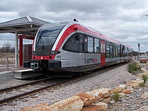
Leander station is a CapMetro Rail hybrid rail station and park and ride in Leander, Texas. The park and ride portion of it, designed by McKinney York Architects, was built in 2007 and is located on Highway 183 just north of FM 2243 and is the northern terminus of the Red Line. Leander station is one of two stations located within Williamson County alongside Lakeline station as opposed to Travis County which contains the other seven locations.
Round Mountain, Travis County, Texas
Unincorporated community in Texas, United States
Distance: Approx. 7941 meters
Latitude and longitude: 30.57555556,-97.94194444
Round Mountain is an unincorporated community in Travis County, in the U.S. state of Texas. According to the Handbook of Texas, the community had a population of 59 in 2000. It is located within the Greater Austin metropolitan area.
Weather in this IP's area
overcast clouds
7 Celsius
4 Celsius
6 Celsius
8 Celsius
1025 hPa
79 %
1025 hPa
990 hPa
10000 meters
4.02 m/s
4.47 m/s
360 degree
100 %