216.201.188.236 - IP Lookup: Free IP Address Lookup, Postal Code Lookup, IP Location Lookup, IP ASN, Public IP
Country:
Region:
City:
Location:
Time Zone:
Postal Code:
ISP:
ASN:
language:
User-Agent:
Proxy IP:
Blacklist:
IP information under different IP Channel
ip-api
Country
Region
City
ASN
Time Zone
ISP
Blacklist
Proxy
Latitude
Longitude
Postal
Route
db-ip
Country
Region
City
ASN
Time Zone
ISP
Blacklist
Proxy
Latitude
Longitude
Postal
Route
IPinfo
Country
Region
City
ASN
Time Zone
ISP
Blacklist
Proxy
Latitude
Longitude
Postal
Route
IP2Location
216.201.188.236Country
Region
texas
City
houston
Time Zone
America/Chicago
ISP
Language
User-Agent
Latitude
Longitude
Postal
ipdata
Country
Region
City
ASN
Time Zone
ISP
Blacklist
Proxy
Latitude
Longitude
Postal
Route
Popular places and events near this IP address
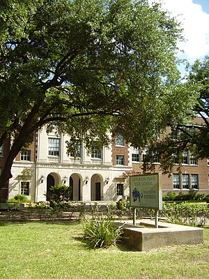
Northside High School (Houston)
Public school in Houston, Texas, United States
Distance: Approx. 1538 meters
Latitude and longitude: 29.78342,-95.3585
Northside High School, formerly Jefferson Davis High School, is a secondary school located at 1101 Quitman in the Near Northside neighborhood of Northside, Houston, Texas with a ZIP code of 77009. The school was previously named after Jefferson Davis, the only president of the Confederate States of America. The school, which serves grades 9 through 12, is a part of the Houston Independent School District.
Woodland Heights, Houston
Historic Neighborhood in Houston, Texas
Distance: Approx. 1781 meters
Latitude and longitude: 29.7839,-95.3828
The Woodland Heights neighborhood is one of the oldest and most historic in Houston, Texas. It encompasses approximately 2000 homes in the 77009 ZIP code and is bounded on the north by Pecore Street, on the west by Studewood Street, on the east by I-45, and on the south by I-10. When platted in 1907 by William A. Wilson, the neighborhood was a 20-minute streetcar ride north of downtown via Houston Avenue.
Near Northside, Houston
Distance: Approx. 1364 meters
Latitude and longitude: 29.786,-95.358
Near Northside is a historic neighborhood located in Northside, Houston, Texas. Near Northside is primarily occupied by people of Hispanic descent. In a 70-year period until 2015 the community had been majority Hispanic after initially being made up of German American and Italian American immigrants who settled in the period 1900-1940.
Lindale Park, Houston
Neighborhood in Houston, Texas
Distance: Approx. 1520 meters
Latitude and longitude: 29.80773,-95.36946
Lindale Park is a neighborhood in Houston, Texas. Lindale Park is east of Interstate 45, inside Interstate 610, and north of Downtown Houston. Lindale Park has many bungalows.

Norhill, Houston
Distance: Approx. 1556 meters
Latitude and longitude: 29.79,-95.384
Norhill, Houston is an historic neighborhood in northwest-central Houston, TX (USA). It is adjacent to the more widely known Houston Heights neighborhood as well as Woodland Heights. Norhill is distinguished by its prevalence of bungalows and the green spaces known as esplanades.

Fulton/North Central station
Distance: Approx. 1198 meters
Latitude and longitude: 29.7858,-95.3607
Fulton/North Central is a light rail station on METRORail's Red Line in Houston, Texas, United States. It opened as part of the Red Line extension on December 21, 2013.
Moody Park station
Distance: Approx. 298 meters
Latitude and longitude: 29.7954,-95.3659
Moody Park is a light rail station on METRORail's Red Line in Houston, Texas, United States. It opened as part of the Red Line extension on December 21, 2013. It services Moody Park.
Cavalcade station
Light rail station in Houston, Texas, US
Distance: Approx. 959 meters
Latitude and longitude: 29.8027,-95.3681
Cavalcade is a light rail station on the Red Line of METRORail in Houston, Texas, United States. It opened on December 21, 2013, as part of the Red Line extension.
Lindale Park station
Distance: Approx. 1605 meters
Latitude and longitude: 29.8085,-95.3695
Lindale Park station is a METRORail light rail station in Houston, Texas. It serves the Red Line and opened as part of the Red Line Extension on December 21, 2013.
Moody Park
Distance: Approx. 539 meters
Latitude and longitude: 29.7925,-95.36333333
Moody Park is a public city park in the Near Northside neighborhood of Houston, Texas. It was opened in 1925 and is managed by the Houston Parks Department. It was the site of the Moody Park riots in 1978.
Travis Elementary School (Houston)
Public elementary school in Texas, USA
Distance: Approx. 788 meters
Latitude and longitude: 29.78916667,-95.37444444
William B. Travis Elementary School is a public elementary school in the Woodland Heights area of Houston, Texas. It is a part of the Houston Independent School District (HISD). It was one of the first HISD schools to have a garden, as well as an outdoor classroom.
Schauer Filling Station
United States historic place
Distance: Approx. 2293 meters
Latitude and longitude: 29.796111,-95.392222
The Schauer Filling Station, formerly located at 1400 Oxford Street, was one of the first gas stations in Houston, in the U.S. state of Texas. The station was completed in 1929, and listed on the National Register of Historic Places. The structure was demolished in June 2013 and delisted on June 14, 2017.
Weather in this IP's area
thunderstorm
17 Celsius
17 Celsius
16 Celsius
19 Celsius
1023 hPa
93 %
1023 hPa
1020 hPa
805 meters
4.12 m/s
180 degree
100 %


