216.201.185.173 - IP Lookup: Free IP Address Lookup, Postal Code Lookup, IP Location Lookup, IP ASN, Public IP
Country:
Region:
City:
Location:
Time Zone:
Postal Code:
ISP:
ASN:
language:
User-Agent:
Proxy IP:
Blacklist:
IP information under different IP Channel
ip-api
Country
Region
City
ASN
Time Zone
ISP
Blacklist
Proxy
Latitude
Longitude
Postal
Route
db-ip
Country
Region
City
ASN
Time Zone
ISP
Blacklist
Proxy
Latitude
Longitude
Postal
Route
IPinfo
Country
Region
City
ASN
Time Zone
ISP
Blacklist
Proxy
Latitude
Longitude
Postal
Route
IP2Location
216.201.185.173Country
Region
texas
City
austin
Time Zone
America/Chicago
ISP
Language
User-Agent
Latitude
Longitude
Postal
ipdata
Country
Region
City
ASN
Time Zone
ISP
Blacklist
Proxy
Latitude
Longitude
Postal
Route
Popular places and events near this IP address
Bear Creek, Texas
Village in Texas, United States
Distance: Approx. 6839 meters
Latitude and longitude: 30.18916667,-97.94472222
Bear Creek is a village in Hays County, Texas, United States. The population was 397 at the 2020 census.

Barton Creek, Texas
CDP in Texas, United States
Distance: Approx. 5988 meters
Latitude and longitude: 30.28,-97.87361111
Barton Creek is a census-designated place (CDP) in Travis County, Texas, United States. As of the 2020 census, the CDP population was 3,356. Barton Creek is ranked second in Texas based on per capita income.
KTXX-FM
Radio station in Bee Cave–Austin, Texas
Distance: Approx. 2126 meters
Latitude and longitude: 30.24911111,-97.90144444
KTXX-FM (104.9 MHz, "La Raza 95.1 y 104.9") is a commercial radio station licensed to Bee Cave, Texas, and serving the Greater Austin metropolitan area. The station broadcasts a Regional Mexican radio format simulcast from KZNX. Genuine Austin Radio owns, and Norsan Media operates the station, with a sale to the latter pending. KTXX-FM's transmitter is located on State Highway 71 in southwest Austin.
LifeAustin Church
Distance: Approx. 1938 meters
Latitude and longitude: 30.249857,-97.903485
Life Family established on the west side of Austin, TX. The church was started in 2005 by pastor Randy Phillips, who is also a member of the musical group Phillips, Craig and Dean. The church has approximately 3,500 congregants.
Circle C Ranch
Master-planned community in Texas, United States
Distance: Approx. 5958 meters
Latitude and longitude: 30.197,-97.904
Circle C Ranch (also known as Circle C) is a large master-planned community in southwest Austin, Texas, USA. Development of Circle C Ranch began in 1982, with the first homes in the community in built in 1986. During development, the subdivision was featured prominently in a long and contentious environmental legal battle regarding urban development in the vicinity of Barton Springs and over Edwards Aquifer. The controversy surrounding its development and later annexation by the city of Austin was a landmark in municipal annexation rights in Texas.

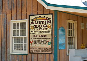
Austin Zoo
Zoo in Texas, U.S.
Distance: Approx. 1553 meters
Latitude and longitude: 30.256876,-97.935761
Austin Zoo is a non-profit rescue zoo and located in southwestern unincorporated Travis County, Texas, United States, west of Austin. The zoo is accreditated by the Zoological Association of America. The mission of Austin Zoo is to assist animals in need through rescue, conservation, and education.
Oak Hill, Austin, Texas
Unincorporated community in Texas, United States
Distance: Approx. 6290 meters
Latitude and longitude: 30.23527778,-97.85972222
Oak Hill is an unincorporated community and collection of neighborhoods located in southwestern Austin, Texas, United States.
St. Michael's Catholic Academy (Travis County, Texas)
School in Austin, Texas, United States
Distance: Approx. 6600 meters
Latitude and longitude: 30.290555,-97.875934
St. Michael's Catholic Preparatory School (formerly St. Michael’s Catholic Academy) is a private college preparatory school in Barton Creek, a community in unincorporated Travis County, Texas (Greater Austin), with an enrollment of approximately 750 students in grades PreK-12.
Scenic Brook, Austin, Texas
Distance: Approx. 3403 meters
Latitude and longitude: 30.236538,-97.890604
Scenic Brook is a neighborhood located in southwest Austin, Texas. Scenic Brook is located in ZIP codes 78735 and 78736. The boundaries are the intersections of U.S. Route 290 and Texas State Highway 71 to on the north, south, and east sides, and Covered Bridge Drive and Scenic Brook Drive on the west side.
Granada Hills, Austin, Texas
Distance: Approx. 3630 meters
Latitude and longitude: 30.221,-97.902
Granada Hills is a neighborhood located in southwest Austin, Texas. Granada Hills is located in ZIP code 78737. The neighborhood boundaries are FM 1826 on the south and east sides, Highway 290 and the Scenic Brook neighborhood to the north, and Southview Road and Belterra on the west side.
Jester King Brewery
Distance: Approx. 7525 meters
Latitude and longitude: 30.2307,-97.9992
Jester King is a craft brewery in Austin, Texas that specializes in beer fermented with wild yeast. It is set on a 40 acre ranch about 18 miles west of Downtown Austin. Jester King was founded in 2010 by Jeff Stuffings and Michael Steffing.
Cedar Valley, Travis County, Texas
Unincorporated community in Texas, United States
Distance: Approx. 4196 meters
Latitude and longitude: 30.2225,-97.95583333
Cedar Valley is an unincorporated community in Travis County, in the U.S. state of Texas. According to the Handbook of Texas, the community had a population of 70 in 2000. It is located within the Greater Austin metropolitan area.
Weather in this IP's area
clear sky
2 Celsius
2 Celsius
-1 Celsius
4 Celsius
1024 hPa
72 %
1024 hPa
990 hPa
10000 meters
0.45 m/s
2.24 m/s
175 degree

