216.201.168.221 - IP Lookup: Free IP Address Lookup, Postal Code Lookup, IP Location Lookup, IP ASN, Public IP
Country:
Region:
City:
Location:
Time Zone:
Postal Code:
IP information under different IP Channel
ip-api
Country
Region
City
ASN
Time Zone
ISP
Blacklist
Proxy
Latitude
Longitude
Postal
Route
Luminati
Country
Region
tx
City
houston
ASN
Time Zone
America/Chicago
ISP
LOGIXCOMM-AS
Latitude
Longitude
Postal
IPinfo
Country
Region
City
ASN
Time Zone
ISP
Blacklist
Proxy
Latitude
Longitude
Postal
Route
IP2Location
216.201.168.221Country
Region
texas
City
austin
Time Zone
America/Chicago
ISP
Language
User-Agent
Latitude
Longitude
Postal
db-ip
Country
Region
City
ASN
Time Zone
ISP
Blacklist
Proxy
Latitude
Longitude
Postal
Route
ipdata
Country
Region
City
ASN
Time Zone
ISP
Blacklist
Proxy
Latitude
Longitude
Postal
Route
Popular places and events near this IP address

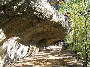
Smith Rock Shelter
United States historic place
Distance: Approx. 4850 meters
Latitude and longitude: 30.1842,-97.7238
The Smith Rock Shelter is a natural limestone overhang in McKinney Falls State Park near Austin, Texas. The shelter is believed to have been used by Native Americans from 500 BCE until the 18th century. The last known occupants were related to the Tonkawa.

McKinney Falls State Park
State park in Texas, United States
Distance: Approx. 4436 meters
Latitude and longitude: 30.18083333,-97.72194444
McKinney Falls State Park is a state park in Austin, Texas, United States at the confluence of Onion Creek and Williamson Creek. It is administered by the Texas Parks and Wildlife Department. The park opened on April 15, 1976 and is named after Thomas F. McKinney, a businessman, race horse breeder and rancher, who owned and lived on the land in the mid-to-late 19th century.

McKinney Homestead
Historic house in Texas, United States
Distance: Approx. 5278 meters
Latitude and longitude: 30.18972222,-97.72055556
The McKinney Homestead is a former limestone home built between 1850 and 1852 by Thomas F. McKinney, owner of the surrounding land. The two-story homestead was continuously occupied until it burned in the 1940s. Archaeological investigations in 1974 determined the house was built with limestone quarried from Onion Creek.

Moore's Crossing Historic District
Historic district in Texas, United States
Distance: Approx. 4466 meters
Latitude and longitude: 30.16805556,-97.66166667
Moore's Crossing Historic District is a community located in rural Travis County nine miles southeast of Austin, Texas near the Austin–Bergstrom International Airport. The location was used as a low-water crossing of Onion Creek as early as the 1840s but did not receive its current name until the early 1900s, when John B. Moore built a store in the area.

Pilot Knob (Austin, Texas)
Eroded core of an extinct volcano located 8 miles (13 km) south of central Austin, Texas
Distance: Approx. 1925 meters
Latitude and longitude: 30.16222222,-97.70611111
Pilot Knob is the eroded core of an extinct volcano located in Austin, Texas, United States. It is near Austin–Bergstrom International Airport and McKinney Falls State Park.
Pilot Knob, Texas
Unincorporated community in Texas, United States
Distance: Approx. 2168 meters
Latitude and longitude: 30.16416667,-97.69305556
Pilot Knob is an unincorporated community in southern Travis County, Texas, United States, named after an extinct volcano found in the area. The area is semi-rural with residences on large lots or acreage and convenience stores and other small businesses. It is located within the Greater Austin metropolitan area.

Circuit of the Americas
Motor race track near Austin, Texas, U.S.
Distance: Approx. 5868 meters
Latitude and longitude: 30.13277778,-97.64111111
Circuit of the Americas (COTA) is a Grade 1 FIA-specification 3.426-mile (5.514 km) motor racing track and facilities located in Austin, Texas, United States. The facility is home to the Formula One United States Grand Prix, NASCAR Texas Grand Prix, and the Motorcycle Grand Prix of the Americas, a round in MotoGP and the FIA World Endurance Championship with the Lone Star Le Mans. It previously hosted the Australian V8 Supercars, the Americas Rallycross Championship, the American Le Mans Series, the Rolex Sports Car Series, the IMSA SportsCar Championship and the IndyCar Classic.

Easton Park
Neighborhood in Austin, Texas, United States
Distance: Approx. 1456 meters
Latitude and longitude: 30.14472222,-97.71527778
Easton Park, also referred to as the Pilot Knob planned unit development, is a 2,214-acre (896 ha) Planned unit development (PUD) in the southeast portion of the city of Austin, Texas, United States. The master-planned community is currently being developed within the Pilot Knob MUD which had been under review since 2012.
Germania Insurance Amphitheater
Sports and concert venue in Texas
Distance: Approx. 5868 meters
Latitude and longitude: 30.13277778,-97.64111111
The Germania Insurance Amphitheater (originally the Tower Amphitheater, then Austin360 Amphitheater) called for sponsorship reasons, is an outdoor amphitheatre that is part of the Circuit of the Americas (COTA) located in Austin, Texas, USA. The venue opened in November 2012 with a capacity of 14,000. There are 6,700 fixed reserved seats. Another 1,700 seats can be configured on the stage-front floor or alternately configured for standing room for 2,300.
Carl, Texas
Unincorporated community in Texas, United States
Distance: Approx. 5921 meters
Latitude and longitude: 30.11416667,-97.74972222
Carl is an unincorporated community in Travis County, in the U.S. state of Texas. It is located within the Greater Austin metropolitan area.
Colton, Texas
Unincorporated community in Texas, United States
Distance: Approx. 532 meters
Latitude and longitude: 30.14972222,-97.69722222
Colton is an unincorporated community in Travis County, in the U.S. state of Texas. According to the Handbook of Texas, the community had a population of 50 in 2000. It is located within the Greater Austin metropolitan area.

Moore's Crossing, Texas
Unincorporated community in Texas, United States
Distance: Approx. 4345 meters
Latitude and longitude: 30.16888889,-97.66388889
Moore's Crossing is an unincorporated community in Travis County, in the U.S. state of Texas. According to the Handbook of Texas, the community had a population of 25 in 2000. It is located within the Greater Austin metropolitan area.
Weather in this IP's area
few clouds
4 Celsius
-0 Celsius
3 Celsius
4 Celsius
1021 hPa
83 %
1021 hPa
998 hPa
10000 meters
4.63 m/s
8.75 m/s
330 degree
20 %