216.201.139.186 - IP Lookup: Free IP Address Lookup, Postal Code Lookup, IP Location Lookup, IP ASN, Public IP
Country:
 USA
USARegion:
City:
Location:
Time Zone:
Postal Code:
ISP:
ASN:
language:
User-Agent:
Proxy IP:
Blacklist:
IP information under different IP Channel
ip-api
Country
Region
City
ASN
Time Zone
ISP
Blacklist
Proxy
Latitude
Longitude
Postal
Route
db-ip
Country
Region
City
ASN
Time Zone
ISP
Blacklist
Proxy
Latitude
Longitude
Postal
Route
IPinfo
Country
Region
City
ASN
Time Zone
ISP
Blacklist
Proxy
Latitude
Longitude
Postal
Route
IP2Location
216.201.139.186Country
usRegion
oklahoma
City
tulsa
Time Zone
America/Chicago
ISP
Language
User-Agent
Latitude
Longitude
Postal
ipdata
Country
Region
City
ASN
Time Zone
ISP
Blacklist
Proxy
Latitude
Longitude
Postal
Route
Popular places and events near this IP address

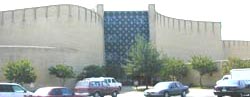
Union Multipurpose Activity Center
Multipurpose arena in Tulsa, Oklahoma
Distance: Approx. 4688 meters
Latitude and longitude: 36.064005,-95.869403
The Union Multipurpose Activity Center (also known as the UMAC or John Q. Hammons Arena) is a 5,662-seat multipurpose arena located in Tulsa, Oklahoma. Built in 2003 at a cost of $22 million, it is the home of the Union High School Redhawks basketball team. It hosted The Summit League's men's basketball tournament from 2005 to 2008.
Union Public Schools
Public school district in Tulsa, Oklahoma
Distance: Approx. 4196 meters
Latitude and longitude: 36.07472222,-95.88222222
Union Public Schools is a public school district located in southeast Tulsa, and northwest Broken Arrow, Oklahoma. The school district is the eighth-largest in Oklahoma. Union is notable among school districts in the area because Union does not encompass a particular city.
The Church at BattleCreek
Distance: Approx. 4178 meters
Latitude and longitude: 36.08472222,-95.81277778
BattleCreek Church is the name and main campus of a moderately growing, Southern Baptist, multi-campus church located in Tulsa.
East Central High School (Oklahoma)
Public school in the United States
Distance: Approx. 4841 meters
Latitude and longitude: 36.146133,-95.839884
East Central High School is one of nine high schools in Tulsa Public Schools in Tulsa, Oklahoma. The school is home to 1,143 students from East Tulsa. The majority of students transition into East Central from East Central Junior High.

Eastgate Metroplex
Shopping mall in Oklahoma, United States
Distance: Approx. 4284 meters
Latitude and longitude: 36.13166667,-95.81972222
Eastgate Metroplex is an indoor mixed-use professional/retail complex in Tulsa, Oklahoma. The building was originally a shopping mall that opened in 1984 as the Eastland Mall, but was revitalized into its current use after years of decline.

Nathan Hale High School (Oklahoma)
School in Oklahoma, US
Distance: Approx. 5099 meters
Latitude and longitude: 36.13189,-95.897589
Nathan Hale High School is a high school in Tulsa, Oklahoma. Opened in 1959, it is part of the Tulsa Public Schools, and is a public school for students from grades 9 through 12. In 2009, the school established a restaurant, lodging, and health management magnet school program, which in 2010 began operating a restaurant open to the public once a week for lunch.
National Weather Service Tulsa, Oklahoma
Distance: Approx. 5090 meters
Latitude and longitude: 36.149,-95.862
National Weather Service - Tulsa, Oklahoma (TSA) is a local weather forecast office responsible for monitoring weather conditions for 7 counties in Northwestern Arkansas, and 25 counties in Eastern Oklahoma. The current office in Tulsa maintains a WSR-88D (NEXRAD) radar system, and Advanced Weather Interactive Processing System (AWIPS) that greatly improve forecasting in the region. Tulsa is in charge of weather forecasts, warnings and local statements as well as aviation weather and NOAA Weather Radio broadcasts in its service area.

Union High School (Tulsa, Oklahoma)
Public school in Tulsa, Oklahoma, United States
Distance: Approx. 4445 meters
Latitude and longitude: 36.06666667,-95.87055556
Union High School is the highest level of secondary education in the Union Public Schools system of Tulsa and Broken Arrow, Oklahoma, for students in 10th, 11th and 12th grades. The school, combined with Union 9th Grade Center, is the second-largest high school in the state of Oklahoma, behind only Broken Arrow High School.
Community Care College
Community college in Tulsa, Oklahoma
Distance: Approx. 4737 meters
Latitude and longitude: 36.1017,-95.9053
Community Care College is a private career college in Tulsa, Oklahoma. The college is the main campus of two branches, Clary Sage College and Oklahoma Technical College. Founded by entrepreneur and Tulsa Oklahoma native Teresa Knox in 1995 as Dental Directions: The School of Dental Assisting, the college eventually expanded its curriculum to other include career oriented programs.
Alsuma, Oklahoma
Ghost town in Oklahoma, United States
Distance: Approx. 1377 meters
Latitude and longitude: 36.095,-95.86333333
Alsuma was a rural community between Tulsa and Broken Arrow in Tulsa County, Oklahoma, United States. Its post office opened in 1905, and was named Welcome, but was renamed Alsuma in 1906. Another version states that the town was named for John Alsuma, a local merchant.
Harvey Young Airport
Airfield in Tulsa, Oklahoma, US
Distance: Approx. 4649 meters
Latitude and longitude: 36.13916667,-95.825
Harvey Young Airport (FAA LID: 1H6) is an airfield located at 1500 S. 135th East Avenue in Tulsa, Oklahoma, United States, owned by Aviation Management Group LLC. This is about 8 miles east of downtown Tulsa. The airport features a 2,580’ x 40’ paved runway, as well as a 2,580’ x 80’ turf runway, both said to be in poor condition (per AirNav.com).
Memorial Park Cemetery (Tulsa)
Cemetery in Tulsa, Oklahoma, U.S.
Distance: Approx. 3274 meters
Latitude and longitude: 36.08638889,-95.88194444
Memorial Park Cemetery is a cemetery in Tulsa, Oklahoma. It is located at 51st Street and South Memorial Drive, and is one of the largest locally formulated cemeteries in the Midwest with both curvilinear and rectilinear design styles. It is the tenth largest cemetery in the United States.
Weather in this IP's area
light intensity drizzle
4 Celsius
0 Celsius
3 Celsius
5 Celsius
1024 hPa
90 %
1024 hPa
998 hPa
3219 meters
5.14 m/s
350 degree
100 %