216.201.132.219 - IP Lookup: Free IP Address Lookup, Postal Code Lookup, IP Location Lookup, IP ASN, Public IP
Country:
 USA
USARegion:
City:
Location:
Time Zone:
Postal Code:
ISP:
ASN:
language:
User-Agent:
Proxy IP:
Blacklist:
IP information under different IP Channel
ip-api
Country
Region
City
ASN
Time Zone
ISP
Blacklist
Proxy
Latitude
Longitude
Postal
Route
db-ip
Country
Region
City
ASN
Time Zone
ISP
Blacklist
Proxy
Latitude
Longitude
Postal
Route
IPinfo
Country
Region
City
ASN
Time Zone
ISP
Blacklist
Proxy
Latitude
Longitude
Postal
Route
IP2Location
216.201.132.219Country
usRegion
texas
City
houston
Time Zone
America/Chicago
ISP
Language
User-Agent
Latitude
Longitude
Postal
ipdata
Country
Region
City
ASN
Time Zone
ISP
Blacklist
Proxy
Latitude
Longitude
Postal
Route
Popular places and events near this IP address

Jersey Village, Texas
City in Texas, United States
Distance: Approx. 5768 meters
Latitude and longitude: 29.89055556,-95.56861111
Jersey Village is a city in west-central Harris County, Texas, United States, located at U.S. Highway 290, Farm to Market Road 529, and the Southern Pacific Railroad. The city is located in the Houston–Sugar Land–Baytown metropolitan area. The population was 7,921 at the 2020 census.

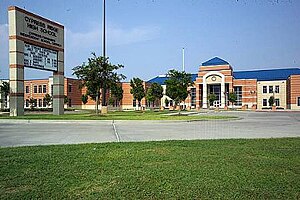
Cypress Falls High School
Public school in Texas, United States
Distance: Approx. 2902 meters
Latitude and longitude: 29.9186,-95.6316
Cypress Falls High School is a secondary school in an unincorporated area of Harris County, Texas, United States. The current principal is Becky Denton. Cypress Falls is part of the Cypress Fairbanks Independent School District, which started during the late 19th century with a school named "The Cypress School".

Cy-Fair High School
Co-educational, public, secondary school in Cypress, Harris County, Texas
Distance: Approx. 4641 meters
Latitude and longitude: 29.939117,-95.652673
Cy-Fair High School is a secondary school located in Cypress, which is an unincorporated place in Harris County, Texas, near Houston. The school is located along U.S. Highway 290 and is part of the Cypress-Fairbanks Independent School District. Cy-Fair High School is the only CFISD high school with a hyphen in its official name.
Cypress Creek High School (Texas)
Public school in Texas, United States
Distance: Approx. 5506 meters
Latitude and longitude: 29.966597,-95.565292
Cypress Creek High School, also known as Cy Creek, is a secondary public school located in unincorporated Harris County, Texas, United States. Cypress Creek, which serves grades 9 through 12, is a part of the Cypress-Fairbanks Independent School District.

Windfern High School
Public secondary school in Harris County , Texas, United States
Distance: Approx. 3161 meters
Latitude and longitude: 29.934231,-95.572801
Windfern High School is a public secondary school located in unincorporated Harris County, Texas, United States. Windfern High School, often referred to as The Lighthouse, is a campus of choice in the Cypress-Fairbanks Independent School District. Windfern's main campus focus is graduation leading to post-high school education and lifelong learning.
Cypress Ridge High School
Public school in Texas, United States
Distance: Approx. 4331 meters
Latitude and longitude: 29.8925,-95.6049
Cypress Ridge High School is a public secondary school located in unincorporated Harris County, Texas, near Houston. It was established in 2002 as Cypress-Fairbanks Independent School District High School #7. Cypress Ridge provides the deaf education program for Cy Fair ISD and surrounding school districts.
Houston Ballet's Ben Stevenson Academy
Ballet school in Houston, Texas
Distance: Approx. 3698 meters
Latitude and longitude: 29.901196,-95.621352
Houston Ballet's Ben Stevenson Academy is a ballet training school affiliated with the Houston Ballet. The academy is housed in Houston Ballet Center for Dance in Houston, Texas.
Satsuma, Texas
Unincorporated area in Texas, US
Distance: Approx. 3131 meters
Latitude and longitude: 29.90333333,-95.60333333
Satsuma (also Ashford and Thompson Switch) is an area in northern unincorporated Harris County, Texas, United States. Satsuma is located along U.S. Route 290, southeast of the community of Cypress and northwest of the city of Jersey Village. It was named for the groves of Satsuma mandarin oranges that were to be planted on site.
Willowbrook, Houston
Area in northwest Houston, Texas
Distance: Approx. 5828 meters
Latitude and longitude: 29.9547,-95.5513
Willowbrook is an area in northwest Houston, Texas, United States, bordered by the Cutten Road to the east, Grant to the north, Rockland to the west, and Beltway 8 to the south. Sam Houston Race Park is one mile away.
Cypress Christian School
Private christian school in Houston, Texas, United States
Distance: Approx. 2874 meters
Latitude and longitude: 29.9521,-95.5876
Cypress Christian School (CCS), formerly Cypress Community Christian School, is a private, non-profit, K-12 Christian school located in unincorporated northwest Harris County, Texas, near Cypress and Houston. The school was founded in 1978. As of April 2024, it has 824 students.
The Oaks Adventist Christian School
School in Cypress, Texas, United States
Distance: Approx. 4774 meters
Latitude and longitude: 29.9741,-95.6008
Houston Adventist Academy, previously known as The Oaks Adventist Christian School, is a private Christian school located in Cypress, an area in unincorporated Harris County, Texas, with PreKindergarten (4 year old) through twelfth grade. It is a part of the Seventh-day Adventist education system, the world's second largest Christian school system.

Ken Pridgeon Stadium
Distance: Approx. 3456 meters
Latitude and longitude: 29.93575833,-95.56993333
Ken Pridgeon Stadium is an outdoor American football stadium located in Houston, Texas. The stadium was built in 1977 and, along with Cy-Fair FCU Stadium, serves as the home field for all Cypress-Fairbanks Independent School District varsity football games, and soccer games. Cy-Fair ISD Stadium was renamed Ken Pridgeon Pridgeon Stadium in 1994, in honor of Oran Kenneth Pridgeon, who served as Cy-Fair ISD Athletic Director from 1967 to 1998.
Weather in this IP's area
overcast clouds
26 Celsius
26 Celsius
25 Celsius
27 Celsius
1020 hPa
67 %
1020 hPa
1014 hPa
10000 meters
2.06 m/s
210 degree
100 %