216.189.207.14 - IP Lookup: Free IP Address Lookup, Postal Code Lookup, IP Location Lookup, IP ASN, Public IP
Country:
Region:
City:
Location:
Time Zone:
Postal Code:
IP information under different IP Channel
ip-api
Country
Region
City
ASN
Time Zone
ISP
Blacklist
Proxy
Latitude
Longitude
Postal
Route
Luminati
Country
Region
tx
City
abilene
ASN
Time Zone
America/Chicago
ISP
TAYLOR-LINK1
Latitude
Longitude
Postal
IPinfo
Country
Region
City
ASN
Time Zone
ISP
Blacklist
Proxy
Latitude
Longitude
Postal
Route
IP2Location
216.189.207.14Country
Region
texas
City
abilene
Time Zone
America/Chicago
ISP
Language
User-Agent
Latitude
Longitude
Postal
db-ip
Country
Region
City
ASN
Time Zone
ISP
Blacklist
Proxy
Latitude
Longitude
Postal
Route
ipdata
Country
Region
City
ASN
Time Zone
ISP
Blacklist
Proxy
Latitude
Longitude
Postal
Route
Popular places and events near this IP address

Abilene, Texas
City in Texas, United States
Distance: Approx. 1594 meters
Latitude and longitude: 32.45,-99.75
Abilene ( AB-i-leen) is a city in Taylor and Jones counties, Texas, United States. Its population was 125,182 at the 2020 census. It is the principal city of the Abilene metropolitan statistical area, which had a population of 176,579 as of 2020.
Texas Tech University at Abilene
Distance: Approx. 2224 meters
Latitude and longitude: 32.468669,-99.732224
Texas Tech University at Abilene is an official off campus teaching site of Texas Tech University located in Abilene, Texas. Degrees and certifications offered by the site include Bachelor of University Studies, Bachelor of General Studies, Graduate Certificate in Wind Energy and Ed.D. in educational leadership. TTU at Abilene primary educational partner is Cisco College.

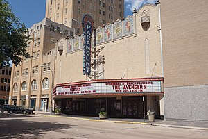
Paramount Theatre (Abilene, Texas)
Distance: Approx. 399 meters
Latitude and longitude: 32.45222222,-99.73388889
The Paramount Theatre is located in downtown Abilene, Texas at 352 Cypress Street. The Paramount was built in 1930 by H. O. Wooten, adjacent to his Hotel Wooten. The theatre opened on May 19, 1930, and the first film shown was Safety in Numbers.

KSLI (AM)
Radio station in Abilene, Texas
Distance: Approx. 1548 meters
Latitude and longitude: 32.44166667,-99.71888889
KSLI (1280 kHz, "92.5 The Ranch" is an AM radio station that serves the Abilene, Texas, area. The station is owned by Townsquare Media and airs a Red Dirt/Texas Country music format, simulcasting KMWX 92.5 FM Abilene. On Monday, March 1, 2010, the news/talk format on KSLI moved to sister station KYYW. KSLI then began broadcasting the classic country format that had been on KYYW. On Monday, February 10, 2020, KSLI transitioned from a classic country music format to a red dirt/Texas country music format.
KVVO-LP
Radio station
Distance: Approx. 168 meters
Latitude and longitude: 32.45,-99.734
KVVO-LP (94.1 FM; "Inspirational Country Radio") is a radio station located in Abilene, Texas, broadcasting a Christian country music format. Inspirational Country Radio is owned by licensee Wildfire Global Church.

The Grace Museum
Art museum in Abilene, Texas
Distance: Approx. 170 meters
Latitude and longitude: 32.44972222,-99.73444444
The Grace Museum is located in Abilene, Texas, United States. The museum is accredited by the American Alliance of Museums (AAM). The Grace Museum houses five art galleries featuring rotating art exhibitions and artwork from the permanent collection; a history gallery with permanent and rotating exhibits featuring Abilene, Taylor County, and West Texas artifacts; an art library; an education center and an interactive gallery for children and families.

Texas Tech University Health Sciences Center at Abilene
Distance: Approx. 2239 meters
Latitude and longitude: 32.4688,-99.7322
Texas Tech University Health Sciences Center at Abilene (TTUHSC Abilene) is a branch campus of Texas Tech University Health Sciences Center (TTUHSC) located in Abilene, Texas. The campus has a school of pharmacy and a school of nursing. The School of Pharmacy opened on August 12, 2007.
National Center for Children's Illustrated Literature
American museum
Distance: Approx. 280 meters
Latitude and longitude: 32.449836,-99.735759
The National Center for Children's Illustrated Literature (NCCIL, pronounced nickle) is an American museum dedicated to illustrations in children's literature. It was established in 2000 and is located in Abilene, Texas.

Hotel Wooten
Residential in Texas, United States
Distance: Approx. 366 meters
Latitude and longitude: 32.4518,-99.7344
The Hotel Wooten is located in downtown Abilene, Texas, United States at 1102 North 3rd Street. This graceful 16-story tower was built at the corner of North 3rd and Cypress Street in 1930 by local business man H.O. Wooten, who according to local legend paid cash for the construction in the midst of the Great Depression. With its massive blue and red neon sign atop its roof, the hotel was visible for miles on the flat Texas plains, particularly at night.

First Presbyterian Church (Abilene, Texas)
Historic church in Texas, United States
Distance: Approx. 661 meters
Latitude and longitude: 32.45333333,-99.7375
First Presbyterian Church is a historic church at 400 Orange Street in Abilene, Texas. The Gothic Revival style building was constructed in 1924 and added to the National Register of Historic Places in 1992.

Abilene Fire Station No. 2
United States historic place
Distance: Approx. 606 meters
Latitude and longitude: 32.44472222,-99.7375
The Abilene Fire Station No. 2, at 441 Butternut in Abilene, Texas, was built in 1926. It was listed on the National Register of Historic Places in 1992.

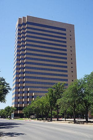
Enterprise Tower
First State Bank Tower and then Bank of America Building
Distance: Approx. 544 meters
Latitude and longitude: 32.4441473,-99.7352076
The Enterprise is a highrise located in Abilene, Texas originally known as the First State Bank Tower and then Bank of America Building. It was constructed in the early 80s and completed by 1984. This is the tallest building in the city at 20 stories 285 feet (87 m) and 6th tallest in West Texas.
Weather in this IP's area
clear sky
9 Celsius
7 Celsius
8 Celsius
9 Celsius
1019 hPa
47 %
1019 hPa
954 hPa
10000 meters
3.6 m/s
20 degree