Country:
 USA
USARegion:
City:
Latitude and Longitude:
Time Zone:
Postal Code:
IP information under different IP Channel
ip-api
Country
Region
City
ASN
Time Zone
ISP
Blacklist
Proxy
Latitude
Longitude
Postal
Route
IPinfo
Country
Region
City
ASN
Time Zone
ISP
Blacklist
Proxy
Latitude
Longitude
Postal
Route
MaxMind
Country
Region
City
ASN
Time Zone
ISP
Blacklist
Proxy
Latitude
Longitude
Postal
Route
Luminati
Country
USASN
Time Zone
America/Chicago
ISP
TEXASNET-ASN
Latitude
Longitude
Postal
db-ip
Country
Region
City
ASN
Time Zone
ISP
Blacklist
Proxy
Latitude
Longitude
Postal
Route
ipdata
Country
Region
City
ASN
Time Zone
ISP
Blacklist
Proxy
Latitude
Longitude
Postal
Route
Popular places and events near this IP address

Bohemia, New York
Hamlet and census-designated place in New York, United States
Distance: Approx. 3058 meters
Latitude and longitude: 40.77,-73.11388889
Bohemia is a hamlet (and census-designated place) in Suffolk County, New York, United States. The population was 9,852 at the 2020 census. It is situated along the South Shore of Long Island in the Town of Islip, approximately 50 miles from New York City.
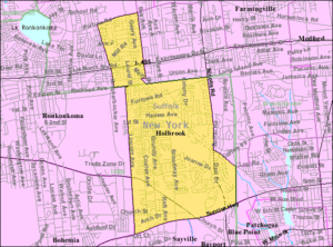
Holbrook, New York
Hamlet and census-designated place in New York, United States
Distance: Approx. 3023 meters
Latitude and longitude: 40.79972222,-73.07555556
Holbrook is a hamlet and census-designated place (CDP) in Suffolk County, New York, United States. The population was 27,195 at the 2010 census. The community borders the eastern side of Long Island MacArthur Airport.
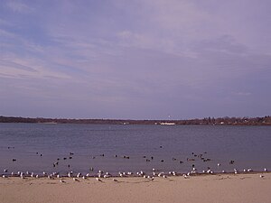
Lake Ronkonkoma, New York
Hamlet and census-designated place in New York, United States
Distance: Approx. 3601 meters
Latitude and longitude: 40.82972222,-73.11305556
Lake Ronkonkoma is a hamlet and census-designated place (CDP) in Suffolk County, on Long Island, in New York, United States. The population was 20,155 at the 2010 census. Lake Ronkonkoma is mainly located in the Town of Brookhaven, but has small sections in the Town of Smithtown and the Town of Islip.

Ronkonkoma, New York
Hamlet and census-designated place in New York, United States
Distance: Approx. 2330 meters
Latitude and longitude: 40.81388889,-73.12833333
Ronkonkoma ( ron-KONG-kə-mə) is a hamlet and census-designated place (CDP) mostly in the Town of Islip of Long Island, with a small eastern portion in the Town of Brookhaven in Suffolk County in New York, United States. The population was 19,082 at the 2010 census. The Ronkonkoma post office has the ZIP Code 11779, and serves parts of several hamlets and CDPs adjacent to Ronkonkoma.

Ronkonkoma station
Long Island Rail Road station in Suffolk County, New York
Distance: Approx. 1274 meters
Latitude and longitude: 40.808088,-73.1059
Ronkonkoma (signed as Ronkonkoma LI MacArthur Airport on station signage) is a major railroad station and transportation hub along the Main Line of the Long Island Rail Road in Ronkonkoma, New York. The station is the eastern terminus of the Ronkonkoma Branch and the western terminus of the Greenport Branch, and it also serves the adjacent Long Island MacArthur Airport. The station is located on Railroad Avenue North across from the intersection of Hawkins Avenue, and has parking facilities and other amenities that extend beyond the central location.
WSHR
Radio station in New York, United States
Distance: Approx. 4367 meters
Latitude and longitude: 40.83555556,-73.09927778
WSHR (91.9 FM, "91.9 The Arrow") is a radio station licensed to Lake Ronkonkoma, New York. The station is owned by the Sachem School District and operates with assistance from a grant by the U.S. Department of Education. It broadcasts out of both Sachem High School East and Sachem High School North.

Connetquot High School
Public high school in Bohemia, New York, United States
Distance: Approx. 2784 meters
Latitude and longitude: 40.78333333,-73.13861111
Connetquot High School (CHS) is a public high school serving students from the 9th–12th grades, located in Bohemia, New York. It is part of the Connetquot Central School District. Connetquot High School's school district, which only has a single comprehensive high school, includes the entirety of the communities of Oakdale and Ronkonkoma, and almost all of Bohemia, while it also serves parts of Islandia, Sayville, and West Sayville.

Holbrook station
Distance: Approx. 2904 meters
Latitude and longitude: 40.810272,-73.08133
Holbrook was a station stop along the Greenport Branch of the Long Island Rail Road. The most recent version was located along Coates Avenue and Railroad Avenue in Holbrook, New York.

1955 MacArthur Airport United Air Lines crash
Airplane crash in New York
Distance: Approx. 958 meters
Latitude and longitude: 40.79527778,-73.10027778
On April 4, 1955, a United Airlines Douglas DC-6 named Mainliner Idaho crashed shortly after taking off from Long Island MacArthur Airport, in Ronkonkoma, Islip, New York, United States. The flight was operated for the purpose of maintaining the currency of the instrument rating of two of the airline's pilots. Shortly after takeoff and only seconds after climbing through 150 feet (46 m), the plane began banking to the right.

Long Island (proposed state)
Proposed U.S. State
Distance: Approx. 2054 meters
Latitude and longitude: 40.789,-73.133
Long Island, a large island directly south of New England, has made attempts in the past to secede from New York and become its own state. Mentions of Long Island secession range from 1896 to 2010. The proposed 51st state has also speculated the combination of Nassau and Suffolk counties into one county in order to reduce costs.
Macabre Faire Film Festival
Film festival in Long Island, New York
Distance: Approx. 2170 meters
Latitude and longitude: 40.789576,-73.134887
The Macabre Faire Film Festival is a film festival held on Long Island, New York. The festival has featured judges and guests such as director Stevan Mena (Bereavement), Eileen Dietz (The Exorcist), Doug Jones (Hell Boy), Cleve Hall (Monster Man), Michael Gingold (Fangoria), Nick Nicholson (CNN Film Critic), Evan Ginzburg (Wrestler) and others.

New York Air Route Traffic Control Center
Distance: Approx. 1930 meters
Latitude and longitude: 40.78388889,-73.09694444
New York Air Route Traffic Control Center (ZNY) (radio communications: "New York Center") is one of 22 Air Route Traffic Control Centers (ARTCCs) operated by the United States Federal Aviation Administration. It is located on the grounds of Long Island MacArthur Airport in Ronkonkoma within the Town of Islip, in Suffolk County, on Long Island, in the state of New York. It is the busiest of all ARTCCs within the United States, and was the world's first en-route air traffic control facility.
Weather in this IP's area
clear sky
17 Celsius
16 Celsius
15 Celsius
18 Celsius
1021 hPa
69 %
1021 hPa
1018 hPa
10000 meters
1.34 m/s
3.58 m/s
27 degree
06:53:24
18:27:45