Country:
Region:
City:
Latitude and Longitude:
Time Zone:
Postal Code:
IP information under different IP Channel
ip-api
Country
Region
City
ASN
Time Zone
ISP
Blacklist
Proxy
Latitude
Longitude
Postal
Route
Luminati
Country
ASN
Time Zone
America/Chicago
ISP
CNSNEXT
Latitude
Longitude
Postal
IPinfo
Country
Region
City
ASN
Time Zone
ISP
Blacklist
Proxy
Latitude
Longitude
Postal
Route
db-ip
Country
Region
City
ASN
Time Zone
ISP
Blacklist
Proxy
Latitude
Longitude
Postal
Route
ipdata
Country
Region
City
ASN
Time Zone
ISP
Blacklist
Proxy
Latitude
Longitude
Postal
Route
Popular places and events near this IP address

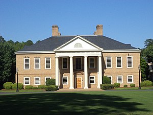
Thomasville, Georgia
City in Georgia, United States
Distance: Approx. 541 meters
Latitude and longitude: 30.83638889,-83.97833333
Thomasville is the county seat of Thomas County, Georgia, United States. The population was 18,881 in 2020. The city deems itself the "City of Roses" and holds an annual Rose Festival.
Flowers Foods
Bakeries of the United States
Distance: Approx. 541 meters
Latitude and longitude: 30.83638889,-83.97833333
Flowers Foods, headquartered in Thomasville, Georgia, is a producer and marketer of packed bakery food. The company operates 47 bakeries producing bread, buns, rolls, snack cakes, pastries, and tortillas. Flowers Foods' products are sold regionally through a direct store delivery network that encompasses the East, South, Southwest, West, and the Northwest regions of the United States and are delivered nationwide to retailer's warehouses.

Thomas County Courthouse (Georgia)
United States historic place
Distance: Approx. 647 meters
Latitude and longitude: 30.83888889,-83.98194444
The Thomas County Courthouse is an historic government building built in 1858 and located on North Broad Street in Thomasville, Georgia, the seat of Thomas County. It was designed by architect John Wind. It was added to the National Register of Historic Places on June 22, 1970.

Thomasville Commercial Historic District
Historic district in Georgia, United States
Distance: Approx. 739 meters
Latitude and longitude: 30.83972222,-83.98194444
Thomasville Commercial Historic District is a historic district that was listed on the National Register of Historic Places in 1984 and was both increased and decreased in 2004. The modified district, about 60 acres (24 ha) in size, then included 123 contributing buildings, three contributing structures, and a contributing object, as well as 65 non-contributing buildings. The district consists primarily of one- and two-story commercial buildings built between 1880 and the 1940s.
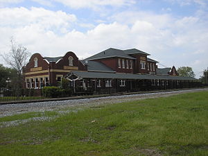
Thomasville Depot (Georgia)
Railway station in Georgia, United States
Distance: Approx. 169 meters
Latitude and longitude: 30.83361111,-83.98416667
The Thomasville Depot in Thomasville, Georgia was built in 1914. It was listed on the National Register of Historic Places in 1988. The station served the Atlantic Coast Line Railroad.

Dr. David Brandon House
Historic house in Georgia, United States
Distance: Approx. 770 meters
Latitude and longitude: 30.84,-83.98305556
The Dr. David Brandon House, also known as Hayes House, in Thomasville, Georgia, was built as a one-story brick house in 1851. A second floor with mansard roof was added in the 1870s.

Hardy Bryan House
Historic house in Georgia, United States
Distance: Approx. 772 meters
Latitude and longitude: 30.84,-83.98166667
The Hardy Bryan House, also known as Cater House, in Thomasville, Georgia, was built in c.1833. It is a well-preserved example of an antebellum plantation house. It was listed on the National Register of Historic Places in 1970.

Gordon Avenue Apartments
United States historic place
Distance: Approx. 663 meters
Latitude and longitude: 30.83027778,-83.97638889
The Gordon Avenue Apartments is an apartment building at 424 Gordon Avenue in Thomasville, Georgia which is listed on the National Register of Historic Places. It is a Tudor Revival building designed by Atlanta architects Daniell and Beutell and built in 1929. Note that Gordon Avenue Historic District, an NRHP-listed district consisting of five houses and their grounds, is further out Gordon Avenue.

Wright House (Thomasville, Georgia)
Historic house in Georgia, United States
Distance: Approx. 168 meters
Latitude and longitude: 30.83168,-83.98192
The Wright House is a historic house located at 415 Fletcher St. in Thomasville, Georgia.

Ephraim Ponder House
Historic house in Georgia, United States
Distance: Approx. 614 meters
Latitude and longitude: 30.838611,-83.982222
The Ephraim Ponder House in Thomasville, Georgia, also known as the Sholar House, was built c.1854-56 It was listed on the National Register of Historic Places in 1970. It was built by Epraim Ponder, and served part of old Young's Female College in Thomasville in 1869 and latterly as home of the president of the old College. At the time of NRHP listing it was owned by John Sholar and wife.
Judge Henry William and Francesca Hopkins House
Historic house in Georgia, United States
Distance: Approx. 774 meters
Latitude and longitude: 30.837854,-83.976595
The Judge Henry William and Francesca Hopkins House in Thomasville, Georgia is located two blocks east of Broad Street, the main commercial street in Thomasville. The house was listed on the National Register of Historic Places in 2013. It was home of Henry William Hopkins (1850-1945) and his wife Francesca (Fannie) Carara Seward (1852-1923).

Fletcherville Historic District
Historic district in Georgia, United States
Distance: Approx. 315 meters
Latitude and longitude: 30.830278,-83.982222
The Fletcherville Historic District is a 38 acres (15 ha) historic district which is roughly bounded by Siexas, Wright, S. College and W. Jackson St. in Thomasville, Georgia. It was listed on the National Register of Historic Places in 1985.
Weather in this IP's area
overcast clouds
18 Celsius
18 Celsius
18 Celsius
19 Celsius
1017 hPa
86 %
1017 hPa
1008 hPa
10000 meters
1.34 m/s
3.58 m/s
77 degree
100 %
07:02:12
17:38:55


