Country:
 USA
USARegion:
City:
Latitude and Longitude:
Time Zone:
Postal Code:
IP information under different IP Channel
ip-api
Country
Region
City
ASN
Time Zone
ISP
Blacklist
Proxy
Latitude
Longitude
Postal
Route
IPinfo
Country
Region
City
ASN
Time Zone
ISP
Blacklist
Proxy
Latitude
Longitude
Postal
Route
MaxMind
Country
Region
City
ASN
Time Zone
ISP
Blacklist
Proxy
Latitude
Longitude
Postal
Route
Luminati
Country
USRegion
mn
City
warroad
ASN
Time Zone
America/Chicago
ISP
WIKTEL
Latitude
Longitude
Postal
db-ip
Country
Region
City
ASN
Time Zone
ISP
Blacklist
Proxy
Latitude
Longitude
Postal
Route
ipdata
Country
Region
City
ASN
Time Zone
ISP
Blacklist
Proxy
Latitude
Longitude
Postal
Route
Popular places and events near this IP address
Cedarbend Township, Roseau County, Minnesota
Township in Minnesota, United States
Distance: Approx. 9498 meters
Latitude and longitude: 48.84222222,-95.40694444
Cedarbend Township is a township in Roseau County, Minnesota, United States. The population was 230 as per the 2000 census. Cedarbend Township was named for the groves of white cedar within its borders.
Lake Township, Roseau County, Minnesota
Township in Minnesota, United States
Distance: Approx. 1143 meters
Latitude and longitude: 48.92,-95.36361111
Lake Township is a township in Roseau County, Minnesota, United States. The population was 2,087 at the 2000 census. This township was originally called Algoma Township, which bears a name of Indian derivation, "formed by Schoolcraft from Algonquin and goma meaning 'Algonquin waters.' It designates a large district in Canada, bordering Lakes Huron and Superior.
Moranville Township, Roseau County, Minnesota
Township in Minnesota, United States
Distance: Approx. 8242 meters
Latitude and longitude: 48.85777778,-95.28333333
Moranville Township is a township in Roseau County, Minnesota, United States. The population was 940 at the 2000 census. Moranville Township was named for Patrick W. Moran, a pioneer settler.
Warroad, Minnesota
City in Minnesota, United States
Distance: Approx. 2864 meters
Latitude and longitude: 48.90527778,-95.31444444
Warroad is a city in Roseau County, Minnesota, United States, at the southwest corner of Lake of the Woods, 7.5 miles (12.1 km) south of Canada. The population was 1,781 at the 2010 census. Warroad had its own newspaper before it was incorporated in 1901.
Warroad International Memorial Airport
Airport
Distance: Approx. 2570 meters
Latitude and longitude: 48.94138889,-95.34833333
Warroad International Memorial Airport (IATA: RRT, ICAO: KRRT, FAA LID: RRT), also known as Swede Carlson Field, is a public use airport in Roseau County, Minnesota, United States. It is owned by the City of Warroad and located two nautical miles (4 km) northwest of its central business district. This airport is included in the National Plan of Integrated Airport Systems for 2017–2021, which categorized it as a general aviation facility.

Elm Point, Minnesota
Uninhabited cape and exclave of the United States
Distance: Approx. 9622 meters
Latitude and longitude: 48.99583333,-95.29
Elm Point, Minnesota, is a small uninhabited cape and a practical exclave of the United States in Lake Township, Roseau County, Minnesota, United States. It is surrounded on the west, south, and east by Lake of the Woods, and on the north by the Canadian First Nation community of Buffalo Point in southeastern Manitoba. Part of Elm Point is privately owned and part of it is state land managed by the Department of Natural Resources as part of the Border Wildlife Management Area.
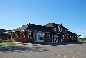
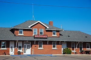
Warroad station
United States historic place
Distance: Approx. 2556 meters
Latitude and longitude: 48.90638889,-95.31833333
Canadian National Depot or Warroad Depot is a former railway station for the Canadian National Railway. The building now serves as an office for the City of Warroad in the U.S. state of Minnesota.
Warroad River
River in Minnesota, United States
Distance: Approx. 3844 meters
Latitude and longitude: 48.90638889,-95.29888889
The Warroad River is a river flowing into Lake of the Woods. It has its mouth in the city of Warroad, Minnesota. The river is formed at the confluence of the East and West Branches Warroad Rivers, south of the city of Warroad, Minnesota.
Warroad High School
Public high school in Warroad, Minnesota, United States
Distance: Approx. 1567 meters
Latitude and longitude: 48.9111,-95.3298
Warroad High School is a public high school in Warroad, Minnesota, United States. Despite the small size of the community, the school has produced several successful hockey players.
Longworth, Minnesota
Unincorporated community in Minnesota, United States
Distance: Approx. 7251 meters
Latitude and longitude: 48.9825,-95.365
Longworth is an unincorporated community in Roseau County, in the U.S. state of Minnesota.
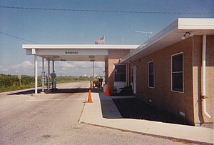
Warroad–Sprague Border Crossing
Port of entry on the Canada-United States border
Distance: Approx. 9212 meters
Latitude and longitude: 48.998994,-95.376154
The Warroad–Sprague Border Crossing connects the city of Warroad, Minnesota and community of Sprague, Manitoba on the Canada–United States border. Minnesota State Highway 313 on the American side joins Manitoba Highway 12 on the Canadian side. The crossing is: on MOM's Way between Thunder Bay, Ontario and Ste.
Weather in this IP's area
clear sky
26 Celsius
26 Celsius
26 Celsius
27 Celsius
1011 hPa
57 %
1011 hPa
974 hPa
10000 meters
4.63 m/s
120 degree
07:00:11
19:32:07