Country:
 USA
USARegion:
City:
Latitude and Longitude:
Time Zone:
Postal Code:
IP information under different IP Channel
ip-api
Country
Region
City
ASN
Time Zone
ISP
Blacklist
Proxy
Latitude
Longitude
Postal
Route
IPinfo
Country
Region
City
ASN
Time Zone
ISP
Blacklist
Proxy
Latitude
Longitude
Postal
Route
MaxMind
Country
Region
City
ASN
Time Zone
ISP
Blacklist
Proxy
Latitude
Longitude
Postal
Route
Luminati
Country
USRegion
mn
City
angleinlet
ASN
Time Zone
America/Chicago
ISP
WIKTEL
Latitude
Longitude
Postal
db-ip
Country
Region
City
ASN
Time Zone
ISP
Blacklist
Proxy
Latitude
Longitude
Postal
Route
ipdata
Country
Region
City
ASN
Time Zone
ISP
Blacklist
Proxy
Latitude
Longitude
Postal
Route
Popular places and events near this IP address
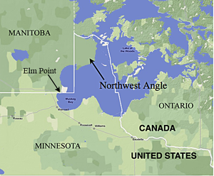
Northwest Angle
Part of Minnesota, separated from the rest of the state by the Lake of the Woods
Distance: Approx. 9023 meters
Latitude and longitude: 49.26666667,-95.05
The Northwest Angle, known simply as the Angle by locals, and coextensive with Angle Township, is a pene-exclave of northern Lake of the Woods County, Minnesota. Except for surveying errors, it is the only place in the contiguous United States north of the 49th parallel, which forms the border between the U.S. and Canada from the Northwest Angle westward to the Strait of Georgia (between the U.S. state of Washington and the Canadian province of British Columbia). The land area of the Angle is separated from the rest of Minnesota by Lake of the Woods, but shares a land border with Canada.
Angle Inlet, Minnesota
Unincorporated community in Minnesota, US
Distance: Approx. 838 meters
Latitude and longitude: 49.345,-95.07
Angle Inlet is a census-designated place (CDP) and unincorporated community in Angle Township, Lake of the Woods County, Minnesota, United States. Its population was 54 as of the 2020 census. The community is part of the Northwest Angle, the only place in the contiguous United States north of the 49th parallel; it is the northernmost census-designated place in the contiguous United States.

Fort Saint Charles
United States historic place
Distance: Approx. 5893 meters
Latitude and longitude: 49.361974,-94.980921
Fort Saint Charles (1732) on Lake of the Woods was the second post built by La Vérendrye during his expansion of trade and exploration west of Lake Superior. It was located on Magnuson's Island on the Northwest Angle of Minnesota, 3.5 miles east of Angle Inlet, Minnesota and one mile southwest of Penasse, Minnesota, the most northerly point in that state. The site of the modern reconstruction may be somewhat different since the lake levels were raised by control structures on the Winnipeg River.
Northwest Angle 33 First Nation
Distance: Approx. 4211 meters
Latitude and longitude: 49.37611111,-95.02111111
Northwest Angle 33 First Nation (Ojibwe: Gii-zaagitoowaigamaag) is an Ojibwe or Ontario Anishinaabe First Nation band government who reside in Kenora District, Ontario near Sioux Narrows of Lake of the Woods. Total registered population in September, 2007, was 438, of which the on-reserve population was 187. The first Nation is a member of the Anishinabeg of Kabapikotawangag Resource Council, a regional tribal council that is a member of the Grand Council of Treaty 3.
Northwest Angle 33B
Indian reserve in Ontario, Canada
Distance: Approx. 5037 meters
Latitude and longitude: 49.38333333,-95.01666667
Northwest Angle 33B is a First Nations reserve in Kenora District, Ontario. It is one of three reserves for the Northwest Angle 33 First Nation.

Northwesternmost point of the Lake of the Woods
Landmark for the boundary between United States and Canada
Distance: Approx. 7979 meters
Latitude and longitude: 49.384479,-95.153391
The northwesternmost point of the Lake of the Woods was a critical landmark for the boundary between United States territory and the British possessions to the north. This point, on the shore of the Lake of the Woods, was referred to in the Treaty of Paris in 1783 and in later treaties including the Treaty of 1818. The point lies at the corner of the Northwest Angle in the U.S. state of Minnesota, and is thus the northernmost point of the contiguous United States.

Northwest Angle State Forest
State Forest in Lake of the Woods County, Minnesota
Distance: Approx. 9455 meters
Latitude and longitude: 49.3111072,-94.9413446
The Northwest Angle State Forest is a state forest located in Lake of the Woods County, Minnesota. The name of the forest is derived from its location near the Northwest Angle, the northernmost point of the contiguous United States. The forest borders the Canadian provinces of Manitoba and Ontario, and the Red Lake Indian Reservation.
Penasse, Minnesota
Unincorporated community in Minnesota, United States
Distance: Approx. 7609 meters
Latitude and longitude: 49.36777778,-94.95888889
Penasse is an unincorporated community in Angle Township, Lake of the Woods County, Minnesota, United States. Penasse is located on Penasse Island in Lake of the Woods, in the northern part of Northwest Angle. Its location makes it the northernmost populated place in the contiguous United States.
Lake of the Woods 31G
Indian reserve in Ontario, Canada
Distance: Approx. 7034 meters
Latitude and longitude: 49.36666667,-94.96666667
Lake of the Woods 31G is a First Nations reserve on Lake of the Woods, northwestern Ontario. It is one of the reserves of the Anishnaabeg of Naongashiing.
Northwest Angle 34C & 37B
Indian reserve in Ontario, Canada
Distance: Approx. 6699 meters
Latitude and longitude: 49.38333333,-95.13333333
Northwest Angle 34C & 37B is a First Nations reserve in Kenora District, Ontario. It borders Manitoba, and is adjacent to the Northwest Angle in Minnesota. It is one of the reserves of the Animakee Wa Zhing 37 First Nation.
Shoal Lake 34B1
Indian reserve in Ontario, Canada
Distance: Approx. 10004 meters
Latitude and longitude: 49.43333333,-95.1
Shoal Lake 34B1 is a First Nations reserve at the southwestern end of Shoal Lake in Kenora District, Ontario. It is one of the reserves of the Animakee Wa Zhing 37 First Nation.
Weather in this IP's area
clear sky
9 Celsius
8 Celsius
7 Celsius
9 Celsius
1014 hPa
71 %
1014 hPa
975 hPa
10000 meters
2.06 m/s
280 degree
07:46:35
18:23:38