216.138.249.64 - IP Lookup: Free IP Address Lookup, Postal Code Lookup, IP Location Lookup, IP ASN, Public IP
Country:
Region:
City:
Location:
Time Zone:
Postal Code:
ISP:
ASN:
language:
User-Agent:
Proxy IP:
Blacklist:
IP information under different IP Channel
ip-api
Country
Region
City
ASN
Time Zone
ISP
Blacklist
Proxy
Latitude
Longitude
Postal
Route
db-ip
Country
Region
City
ASN
Time Zone
ISP
Blacklist
Proxy
Latitude
Longitude
Postal
Route
IPinfo
Country
Region
City
ASN
Time Zone
ISP
Blacklist
Proxy
Latitude
Longitude
Postal
Route
IP2Location
216.138.249.64Country
Region
ontario
City
brampton
Time Zone
America/Toronto
ISP
Language
User-Agent
Latitude
Longitude
Postal
ipdata
Country
Region
City
ASN
Time Zone
ISP
Blacklist
Proxy
Latitude
Longitude
Postal
Route
Popular places and events near this IP address

Bramalea, Ontario
Suburban district in Peel, Ontario, Canada
Distance: Approx. 2997 meters
Latitude and longitude: 43.725,-79.7175
Bramalea (Bram-a-lee) is a large suburban district in the City of Brampton, Ontario, Canada. Bramalea was created as an innovative "new town", and developed as a separate community from the original Town of Brampton. Located in the former Chinguacousy Township, it was Canada's first satellite community developed by one of the country's largest real estate developers, Bramalea Consolidated Developments (later Bramalea Limited).

Bramalea—Gore—Malton (federal electoral district)
Former federal electoral district in Ontario, Canada
Distance: Approx. 2273 meters
Latitude and longitude: 43.72333333,-79.69277778
Bramalea—Gore—Malton (formerly known as Brampton—Malton and Bramalea—Gore—Malton—Springdale) was a federal electoral district in Ontario, Canada, that was represented in the House of Commons of Canada. In 2015, it was dissolved into the ridings of Brampton East, Mississauga—Malton, Brampton Centre and Brampton North. The district was created as "Brampton—Malton" in 1987 from Brampton—Georgetown and Mississauga North.
Holy Name of Mary Catholic Secondary School
High school in Brampton, Canada
Distance: Approx. 2342 meters
Latitude and longitude: 43.7338,-79.7164
Holy Name of Mary Catholic Secondary School is an all-girls regional high school in Brampton, Ontario, Canada founded by the Felician Sisters. Originally located in Mississauga, it relocated to Brampton in 2008. Holy Name of Mary Catholic Secondary School is the only single-sex school in the Dufferin-Peel Catholic District School Board.

Chinguacousy Secondary School
High school in Brampton, Ontario, Canada
Distance: Approx. 3000 meters
Latitude and longitude: 43.7375,-79.727
Chinguacousy Secondary School founded in 1972, is a high school located in Brampton, Ontario, Canada. Since 2000, the school's enrolment has expanded with the development of the surrounding area. The school sports teams and athletic programs have won a number of OFSAA championships; wrestling (1991, 1992, 1993, 1995), curling (1996, 1998), and rugby (1982).
Bramalea Secondary School
Public high school in Brampton, Ontario, Canada
Distance: Approx. 3444 meters
Latitude and longitude: 43.715302,-79.707693
Bramalea Secondary School (BSS) is a high school located in Bramalea, Brampton, Ontario, operating under the Peel District School Board established in 1963.

Professor's Lake
Artificial lake in Brampton, Ontario
Distance: Approx. 3565 meters
Latitude and longitude: 43.7475,-79.73472222
Professor's Lake is a 65-acre (26 ha) spring-fed artificial lake located in Brampton, Ontario, Canada. In 1918, the area where the lake currently exists was a sand and gravel mining site supplying aggregates for construction projects in the northwest area of the Greater Toronto Area. During its lifetime, the site produced approximately 20 million tonnes (40 million tons) of aggregate.

Bramalea—Gore—Malton (provincial electoral district)
Provincial electoral district in Ontario, Canada
Distance: Approx. 2622 meters
Latitude and longitude: 43.72027778,-79.68722222
Bramalea—Gore—Malton was a provincial electoral district in Southern Ontario, Canada. It was created for the 2007 provincial election. All of the district was carved from Bramalea—Gore—Malton—Springdale.
Judith Nyman Secondary School
Secondary school in Brampton, Ontario, Canada
Distance: Approx. 3445 meters
Latitude and longitude: 43.73239,-79.73057
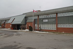
Judith Nyman Secondary School is a high school in Brampton, Ontario, Canada. It is one of two vocational schools operated by the Peel District School Board, the other being West Credit Secondary School in Mississauga. Upon graduation from Judith Nyman Secondary School, students receive an Ontario Secondary School Diploma or Certificate and may also qualify for a Skills Portfolio, which lists the trade-specific skills that the student has mastered through his or her in-school and co-op education courses.
St. Thomas Aquinas Secondary School (Brampton)
Catholic school in Brampton, Canada
Distance: Approx. 1699 meters
Latitude and longitude: 43.73895,-79.71077
St. Thomas Aquinas or STA is a Catholic secondary school in Bramalea, Brampton, Ontario. It is under Dufferin-Peel Catholic District School Board.

Donald M. Gordon Chinguacousy Park
Park in Brampton, Ontario, Canada
Distance: Approx. 3050 meters
Latitude and longitude: 43.72472222,-79.71805556
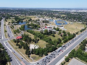
Donald M. Gordon Chinguacousy Park, colloquially known as Chinguacousy Park, is a large 40-hectare (100-acre) park in the Bramalea section of Brampton, Ontario, Canada. It is bounded by Queen Street East on the southeast, Bramalea Road on the northeast, and Central Park Drive on the north and west sides. Terry Fox Stadium (Brampton) in the north of the park, sometimes called Terry Fox Track and Field Stadium, has a track and field oval surrounding an artificial turf field with Canadian Football markings and stands for about 1000 spectators.
Kwakiutl (statue)
Totem sculpture by Simon Charlie
Distance: Approx. 3378 meters
Latitude and longitude: 43.72283056,-79.72118056
Kwakiutl (or variously KwaKiutl) is a totem sculpture by Cowichan Tribes artist Simon Charlie, which has caused controversy for its nudity over multiple decades of display in Chinguacousy Township, and later Brampton, both near Toronto in Ontario, Canada. Charlie, also known as Hwunumetse', later received the Order of Canada. The 9-foot-tall cedar wood sculpture is best known for its exposed male genitals.
Goreway Power Station
Natural gas power station in Brampton, Ontario, Canada
Distance: Approx. 901 meters
Latitude and longitude: 43.74611111,-79.68
Goreway Power Station is a natural gas power station in Brampton, Ontario. It is owned by Capital Power. Gas is supplied by underground pipelines from a nearby Enbridge facility.
Weather in this IP's area
broken clouds
-7 Celsius
-10 Celsius
-8 Celsius
-7 Celsius
1009 hPa
62 %
1009 hPa
981 hPa
10000 meters
1.34 m/s
5.36 m/s
234 degree
84 %

