Country:
 USA
USARegion:
City:
Latitude and Longitude:
Time Zone:
Postal Code:
IP information under different IP Channel
ip-api
Country
Region
City
ASN
Time Zone
ISP
Blacklist
Proxy
Latitude
Longitude
Postal
Route
IPinfo
Country
Region
City
ASN
Time Zone
ISP
Blacklist
Proxy
Latitude
Longitude
Postal
Route
MaxMind
Country
Region
City
ASN
Time Zone
ISP
Blacklist
Proxy
Latitude
Longitude
Postal
Route
Luminati
Country
USRegion
il
City
quincy
ASN
Time Zone
America/Chicago
ISP
ASN-AT-12033
Latitude
Longitude
Postal
db-ip
Country
Region
City
ASN
Time Zone
ISP
Blacklist
Proxy
Latitude
Longitude
Postal
Route
ipdata
Country
Region
City
ASN
Time Zone
ISP
Blacklist
Proxy
Latitude
Longitude
Postal
Route
Popular places and events near this IP address
Quincy, Illinois
City in Illinois, United States
Distance: Approx. 1075 meters
Latitude and longitude: 39.93222222,-91.38861111
Quincy ( KWIN-see) is a city in and the county seat of Adams County, Illinois, United States, located on the Mississippi River. The population was 39,463 as of the 2020 census, down from 40,633 in 2010. The Quincy micropolitan area had 114,649 residents.

Quincy University
Franciscan university in Quincy, Illinois, US
Distance: Approx. 1362 meters
Latitude and longitude: 39.9407,-91.386
Quincy University (QU) is a private Franciscan university founded in 1860 in Quincy, Illinois.
Quincy Senior High School
School in Illinois, US
Distance: Approx. 1201 meters
Latitude and longitude: 39.93,-91.3621
Quincy Senior High School is the regional public high school for Quincy, Illinois. It is the largest high school in Adams County, Illinois, and the only high school in Quincy Public School District 172. As of 2020, it is the 17th largest high school in Illinois by enrollment outside of Chicago.

Quincy National Cemetery
Historic veterans cemetery in Adams County, Illinois
Distance: Approx. 1758 meters
Latitude and longitude: 39.93222222,-91.35555556
Quincy National Cemetery is a small United States National Cemetery located in the city of Quincy, in Adams County, Illinois. Administered by the United States Department of Veterans Affairs, it encompasses slightly less than a half an acre, and as 2014, had 690 interments. It is currently closed to new interments, and is maintained by Rock Island National Cemetery.
QU Stadium
Stadium in Illinois, US
Distance: Approx. 2023 meters
Latitude and longitude: 39.947517,-91.386253
QU Stadium is a stadium in Quincy, Illinois originally known as Q Stadium. It is primarily used for baseball, but also has a separate football field. The baseball side of QU Stadium holds 2,000 people and the football/lacrosse side of holds 1,600 people.
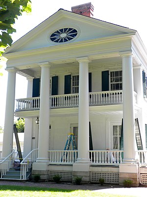
John Wood Mansion
Historic house in Illinois, United States
Distance: Approx. 1755 meters
Latitude and longitude: 39.92666667,-91.39583333
The John Wood Mansion was built between 1835 and 1838 by John Wood, who in 1860 became the 12th governor of Illinois on the death of Governor William Bissell. The Wood family moved into the Greek Revival home situated at 12th and State Streets in Quincy, Illinois from an unusual two-story log cabin in 1837. Quincy is the county seat of Adams County.
Quincy, Illinois, micropolitan area
Micropolitan Statistical Area in the United States
Distance: Approx. 666 meters
Latitude and longitude: 39.93333333,-91.38333333
The Quincy–Hannibal, IL–MO Combined Statistical Area, as defined by the United States Census Bureau, is an area consisting of one county in Western Illinois and three counties in northeast Missouri, anchored by the cities of Quincy and Hannibal. As of the 2020 census, the μSA had a population of 114,649.
Quincy Town Center
Mixed-use development in Quincy, Illinois, USA
Distance: Approx. 1369 meters
Latitude and longitude: 39.93726,-91.36222
Quincy Town Center, formerly Quincy Mall, is a shopping mall and office complex in Quincy, Illinois. It was formerly known as Quincy Mall from 1978 to 2021 and was originally an outdoor complex called the American Legion Miracle Mile Town and Country Shopping Center. The outdoor shopping center opened in 1958.

Coca-Cola Bottling Company Building (Quincy, Illinois)
United States historic place
Distance: Approx. 808 meters
Latitude and longitude: 39.93833333,-91.37694444
The Coca-Cola Bottling Company Building is a historic Coca-Cola bottling plant located at 616 North 24th Street in Quincy, Illinois. The building was constructed in 1940 for the J. J. Flynn Co., Coca-Cola's regional bottling company in Quincy and one of six Coca-Cola bottlers in Illinois. Local architect Martin J. Geise designed the Art Deco building, one of the few examples of Art Deco in an industrial building in Quincy.
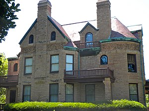
William S. Warfield House
Historic house in Illinois, United States
Distance: Approx. 1163 meters
Latitude and longitude: 39.93138889,-91.38972222
The William S. Warfield House is a historic house located at 1624 Maine Street in Quincy, Illinois. The house was built in 1886 for William S. Warfield, who founded the Warfield Grocery Co.; Warfield was one of many prominent Quincy residents to build a large house on Maine Street. Architect Joseph Lyman Silsbee designed the house in a blend of the Richardsonian Romanesque and Queen Anne styles; his design popularized Romanesque architecture, and the blend with Queen Anne in particular, in Quincy.
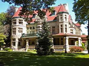
Richard F. Newcomb House
Historic house in Illinois, United States
Distance: Approx. 1193 meters
Latitude and longitude: 39.93222222,-91.39
The Richard F. Newcomb House is a historic house located at 1601 Maine Street in Quincy, Illinois. The house was built in 1890-91 for Richard F. Newcomb, the founder of the Quincy Paper Company; the company eventually became a national strawboard-producing firm. Local architects Harvey Chatten and Ernest M. Wood collaborated on the house's Richardsonian Romanesque design; the style choice was inspired by the recently built William S. Warfield House, which Newcomb admired and wished to outdo.

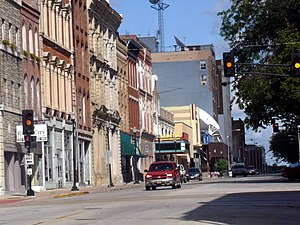
Quincy East End Historic District
Historic district in Illinois, United States
Distance: Approx. 879 meters
Latitude and longitude: 39.93083333,-91.38638889
The Quincy East End Historic District is a residential historic district located on the east side of Quincy, Illinois. The district encompasses 493 contributing buildings built from the 1830s to the 1930s, including representative works of nearly every popular American architectural style during the period. The homes in the district were planned by designers of all skill levels, from local craftsmen to nationally significant architects, and the district developed naturally as formal and vernacular styles rose and fell in popularity.
Weather in this IP's area
clear sky
9 Celsius
9 Celsius
8 Celsius
11 Celsius
1025 hPa
83 %
1025 hPa
1001 hPa
10000 meters
06:40:32
19:25:49