216.130.46.204 - IP Lookup: Free IP Address Lookup, Postal Code Lookup, IP Location Lookup, IP ASN, Public IP
Country:
Region:
City:
Location:
Time Zone:
Postal Code:
ISP:
ASN:
language:
User-Agent:
Proxy IP:
Blacklist:
IP information under different IP Channel
ip-api
Country
Region
City
ASN
Time Zone
ISP
Blacklist
Proxy
Latitude
Longitude
Postal
Route
db-ip
Country
Region
City
ASN
Time Zone
ISP
Blacklist
Proxy
Latitude
Longitude
Postal
Route
IPinfo
Country
Region
City
ASN
Time Zone
ISP
Blacklist
Proxy
Latitude
Longitude
Postal
Route
IP2Location
216.130.46.204Country
Region
florida
City
fort lauderdale
Time Zone
America/New_York
ISP
Language
User-Agent
Latitude
Longitude
Postal
ipdata
Country
Region
City
ASN
Time Zone
ISP
Blacklist
Proxy
Latitude
Longitude
Postal
Route
Popular places and events near this IP address
Las Olas Boulevard
Road in Fort Lauderdale, Florida
Distance: Approx. 610 meters
Latitude and longitude: 26.1193,-80.13496
Las Olas Boulevard is a major east-west thoroughfare in Fort Lauderdale, Florida, United States that runs from SW 1st Avenue in the Central Business District to Florida State Road A1A in Fort Lauderdale Beach. The name "Las Olas" means "The Waves" in Spanish. The road once carried the designations of State Road A1A Alt.
New River Tunnel
Road tunnel in Fort Lauderdale, Florida
Distance: Approx. 853 meters
Latitude and longitude: 26.118,-80.137
The New River Tunnel, officially known as the Henry E. Kinney Tunnel, is a highway tunnel that carries U.S. Route 1 underneath the New River and Las Olas Boulevard in downtown Fort Lauderdale. The tunnel replaced the Federal Aid Highway Bridge, a drawbridge opened on August 26, 1926, and closed in 1958. Upon its completion in 1960, it was the only operating public tunnel in Florida (this changed with the completion of the Port of Miami Tunnel in 2014.

Stranahan House
Historic house in Florida, United States
Distance: Approx. 948 meters
Latitude and longitude: 26.11805556,-80.13805556
Stranahan House is the home of Fort Lauderdale pioneers Frank and Ivy Stranahan. Built in 1901 as a trading post and converted into a residence for the Stranahans in 1906, the house is the oldest surviving structure in Broward County. It was placed on the National Register of Historic Places in 1973 and today operates as a historic house museum.

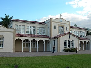
St. Anthony School (Florida)
United States historic place
Distance: Approx. 479 meters
Latitude and longitude: 26.12387222,-80.13286111
St. Anthony Catholic School is a historic school in Fort Lauderdale, Florida. It is located at 820 Northeast 3rd Street.
One Financial Plaza (Fort Lauderdale)
Office in Florida,States
Distance: Approx. 1081 meters
Latitude and longitude: 26.12166667,-80.14
One Financial Plaza is a 374 ft (114 m), 28-story building in downtown Fort Lauderdale, Florida, USA, was opened in 1972. At the time of its opening, it was the tallest building in the Fort Lauderdale area. It has since been surpassed by several buildings.
Florida Atlantic University College of Education
Academic college of Florida Atlantic University, Boca Raton, Florida
Distance: Approx. 1220 meters
Latitude and longitude: 26.119988,-80.141341
The FAU College of Education is located in Boca Raton, Florida and is one of the ten academic colleges of Florida Atlantic University It offers education degree programs at the undergraduate and graduate levels. The College of Education is one of the original colleges that opened when Florida Atlantic University first began offering courses in 1964.

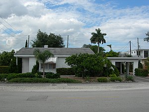
Alfred and Olive Thorpe Lustron House
Historic house in Florida, United States
Distance: Approx. 556 meters
Latitude and longitude: 26.12444444,-80.13333333
The Alfred and Olive Thorpe Lustron House is a historic Lustron house built in 1950, located at 1001 Northeast 2nd Street in Fort Lauderdale, Florida.
Rio Vista (Fort Lauderdale)
Neighborhood in Fort Lauderdale, Florida, US
Distance: Approx. 1106 meters
Latitude and longitude: 26.1112111,-80.1302969
The Rio Vista neighborhood is a community of over 1,000 homes, situated next to downtown Fort Lauderdale, Florida. Its name means "River View" in Spanish. It is one of the oldest communities in Fort Lauderdale and features tree-lined streets, sidewalks and unique architecture.

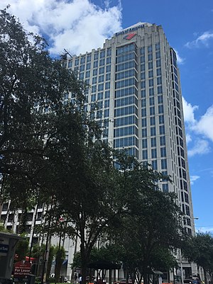
Bank of America Plaza (Fort Lauderdale)
Office in Florida, United States
Distance: Approx. 988 meters
Latitude and longitude: 26.119782,-80.13898
Bank of America Plaza is a 365 feet (111 m), 23-story office building located at Las Olas City Centre in downtown Fort Lauderdale, Florida. The structure was finished in early 2003, and contains a parking garage which is located on the second to sixth floors, a small retail mall, and a Bank of America—the building's namesake tenant—on the ground floor. It is currently the fifth tallest building in Ft.

PNC Center (Fort Lauderdale)
Office in Florida, United States
Distance: Approx. 1173 meters
Latitude and longitude: 26.1219,-80.1409
PNC Center is a high-rise located in downtown Fort Lauderdale, Florida. The building opened in 1991, as First Union Center and later renamed Wachovia Center, after Wachovia became the building's largest tenant.
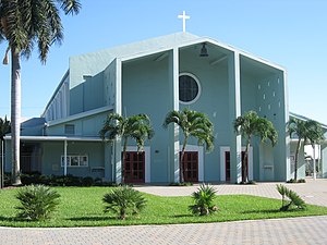
All Saints Episcopal Church (Fort Lauderdale, Florida)
Church in Fort Lauderdale, Florida
Distance: Approx. 274 meters
Latitude and longitude: 26.1187,-80.1298
All Saints Episcopal Church is a parish of the Episcopal Diocese of Southeast Florida founded in the year 1912.

Riverside Hotel (Fort Lauderdale, Florida)
Hotel in Fort Lauderdale, Florida
Distance: Approx. 782 meters
Latitude and longitude: 26.118333,-80.136389
The Riverside Hotel is a historic luxury hotel located in Fort Lauderdale, Florida, on the New River, adjacent to the Stranahan House, on Las Olas Boulevard. The hotel was built in 1925 and opened in 1936. It is the oldest continuously operating hotel in Fort Lauderdale and is one of the oldest hotels in Broward County.
Weather in this IP's area
broken clouds
12 Celsius
11 Celsius
12 Celsius
13 Celsius
1026 hPa
66 %
1026 hPa
1026 hPa
10000 meters
7.39 m/s
10.23 m/s
358 degree
59 %


