216.126.70.190 - IP Lookup: Free IP Address Lookup, Postal Code Lookup, IP Location Lookup, IP ASN, Public IP
Country:
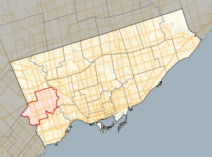
 Canada
Region:
City:
Location:
Time Zone:
Postal Code:
ISP:
ASN:
language:
User-Agent:
Proxy IP:
Blacklist:
IP information under different IP Channel
ip-api
Country
Region
City
ASN
Time Zone
ISP
Blacklist
Proxy
Latitude
Longitude
Postal
Route
db-ip
Country
Region
City
ASN
Time Zone
ISP
Blacklist
Proxy
Latitude
Longitude
Postal
Route
IPinfo
Country
Region
City
ASN
Time Zone
ISP
Blacklist
Proxy
Latitude
Longitude
Postal
Route
IP2Location
216.126.70.190Country
caRegion
ontario
City
etobicoke
Time Zone
America/Toronto
ISP
Language
User-Agent
Latitude
Longitude
Postal
ipdata
Country
Region
City
ASN
Time Zone
ISP
Blacklist
Proxy
Latitude
Longitude
Postal
Route
Popular places and events near this IP address

Kipling station
Toronto subway station
Distance: Approx. 1609 meters
Latitude and longitude: 43.6375,-79.53555556
Kipling is the western terminus station of Line 2 Bloor–Danforth of the Toronto subway system. The station is served by buses and subway trains operated by the Toronto Transit Commission and is adjacent to the Kipling GO Station on the Milton line of GO Transit and the Kipling Bus Terminal, where passengers can connect with MiWay and GO Transit bus services. It opened on November 21, 1980, as part of the extensions west, to this station, and east to Kennedy station.

Kipling GO Station
Railway station in Toronto, Ontario, Canada
Distance: Approx. 1455 meters
Latitude and longitude: 43.63611111,-79.53694444
Kipling GO Station is a GO Transit railway station along the Milton line rail corridor in Toronto, Ontario, Canada. It is located at 27 St. Albans Road in the Islington-City Centre West neighbourhood of Toronto (formerly Etobicoke), near Dundas Street.

Etobicoke Civic Centre
Civic building in Toronto, Canada
Distance: Approx. 1559 meters
Latitude and longitude: 43.64388889,-79.56555556
The Etobicoke Civic Centre in the Eatonville neighbourhood of Toronto, Ontario, Canada, once housed the municipal government of the former City of Etobicoke. The building was built in 1958 by the firm Shore and Moffat to replace the single storey brick Township of Etobicoke Municipal Hall at 4946 Dundas Street (now Fox and a Fiddle pub). The building exterior is clad in Queenston limestone and framed by glass and aluminum.

Eatonville, Toronto
Neighbourhood in Toronto, Ontario, Canada
Distance: Approx. 884 meters
Latitude and longitude: 43.63888889,-79.54777778
Eatonville is a neighbourhood in Toronto, Ontario, Canada. It is located west of the central core, in the former suburb of Etobicoke. Eatonville is bisected by Highway 427, with the community generally located north of Dundas Street West and south of Rathburn Road.

Markland Wood
Neighbourhood in Toronto, Ontario, Canada
Distance: Approx. 1668 meters
Latitude and longitude: 43.63222222,-79.575
Markland Wood is a residential neighbourhood in Toronto, Ontario, Canada. It is located west of the central core, in the former suburb of Etobicoke and is the westernmost residential community in Toronto along Bloor Street West. It's located on the border of Mississauga and bounded by Etobicoke Creek to the west, Elmcrest Creek to the east, Burnhamthorpe to the North, and surrounded by the Markland Wood Golf Club; approximately 2/3 is north of Bloor Street, and 1/3 south.
Etobicoke Centre (provincial electoral district)
Provincial electoral district in Ontario, Canada
Distance: Approx. 1747 meters
Latitude and longitude: 43.648,-79.5577
Etobicoke Centre is a provincial electoral district in Toronto, Ontario, Canada. It elects one member to the Legislative Assembly of Ontario. It was created in 1999 from parts of Etobicoke West and Etobicoke—Humber.

Honeydale Mall
Shopping mall in Ontario, Canada
Distance: Approx. 697 meters
Latitude and longitude: 43.6294,-79.54679
Honeydale Mall was a community shopping mall in Toronto, Ontario, Canada. It was located at the intersection of Dundas Street and The East Mall Crescent (the latter being a link connecting the grade-separated roads, The East Mall and Dundas Street). It served the Eatonville neighbourhood of Etobicoke district.

Cloverdale Mall
Shopping mall
Distance: Approx. 136 meters
Latitude and longitude: 43.63138889,-79.555
Cloverdale Mall is a community shopping centre located in the Etobicoke district of Toronto, Ontario, Canada, at 250 The East Mall northeast of the intersection of Dundas Street West and Highway 427). It opened in 1956 as an open-air shopping plaza on what was part of the Eatonville farm.

2003 Etobicoke gas explosion
Distance: Approx. 1297 meters
Latitude and longitude: 43.6401,-79.5421
The 2003 Etobicoke gas explosion was a disaster which occurred on April 24, 2003, after a backhoe operated by Enbridge contractor Precision Utility breached a pipeline on Bloor Street in the Etobicoke district of Toronto, Ontario. The resulting explosion destroyed a two-story mixed commercial and residential building, killing seven people and injuring another four. Enbridge and several other companies were fined for the disaster in 2011.
Etobicoke Hall of Fame
Distance: Approx. 1528 meters
Latitude and longitude: 43.64365,-79.56537
Etobicoke Hall of Fame is a civic hall of fame in Toronto, Ontario, Canada. It began as a project of Etobicoke, a borough of Metropolitan Toronto. Etobicoke is now part of the larger city of Toronto.
Eatonville Care Centre
Distance: Approx. 1751 meters
Latitude and longitude: 43.64752778,-79.56072222
Eatonville Care Centre is a privately owned long-term care facility in the Eatonville area of Etobicoke, Toronto, Ontario, Canada. As of 2020, it is owned by Rykka Care Centres. During the COVID-19 pandemic, it was particularly hard-hit, with 142 resident cases and 40 resident deaths.
Kipling Bus Terminal
Regional bus terminal in Toronto, Canada
Distance: Approx. 1331 meters
Latitude and longitude: 43.63555556,-79.53833333
Kipling Bus Terminal is a regional bus terminal in Toronto, Ontario, Canada. The terminal serves MiWay and GO Transit buses. It is owned by Metrolinx and is a part of the Kipling Transit Hub, a Metrolinx mobility hub, together with Kipling station and Kipling GO Station.
Weather in this IP's area
broken clouds
-5 Celsius
-12 Celsius
-6 Celsius
-4 Celsius
1011 hPa
79 %
1011 hPa
996 hPa
10000 meters
11.32 m/s
310 degree
75 %