216.126.198.13 - IP Lookup: Free IP Address Lookup, Postal Code Lookup, IP Location Lookup, IP ASN, Public IP
Country:
 USA
USARegion:
City:
Location:
Time Zone:
Postal Code:
ISP:
ASN:
language:
User-Agent:
Proxy IP:
Blacklist:
IP information under different IP Channel
ip-api
Country
Region
City
ASN
Time Zone
ISP
Blacklist
Proxy
Latitude
Longitude
Postal
Route
db-ip
Country
Region
City
ASN
Time Zone
ISP
Blacklist
Proxy
Latitude
Longitude
Postal
Route
IPinfo
Country
Region
City
ASN
Time Zone
ISP
Blacklist
Proxy
Latitude
Longitude
Postal
Route
IP2Location
216.126.198.13Country
usRegion
kentucky
City
lexington
Time Zone
America/New_York
ISP
Language
User-Agent
Latitude
Longitude
Postal
ipdata
Country
Region
City
ASN
Time Zone
ISP
Blacklist
Proxy
Latitude
Longitude
Postal
Route
Popular places and events near this IP address
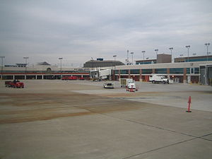
Blue Grass Airport
Public airport in Fayette County, Kentucky, U.S.
Distance: Approx. 2813 meters
Latitude and longitude: 38.03638889,-84.60583333
Blue Grass Airport (IATA: LEX, ICAO: KLEX, FAA LID: LEX) is a public airport in Fayette County, Kentucky, United States, 6 miles west of downtown Lexington. Located among horse farms and situated directly across from Keeneland Race Course, Blue Grass Airport is the primary airport serving central and eastern Kentucky. More than 1.3 million passengers depart or arrive annually at Blue Grass Airport.

Paul Laurence Dunbar High School (Lexington, Kentucky)
Public high school in Lexington, Fayette County, Kentucky, United States
Distance: Approx. 1602 meters
Latitude and longitude: 38.01782,-84.57683
Paul Laurence Dunbar High School (PLD/PLDHS), also known as Dunbar High School, is a public high school located at 1600 Man o' War Boulevard on the southwest side of Lexington, Kentucky, United States. The school is one of six high schools in the Fayette County Public Schools district. The school was opened in 1990.

Aviation Museum of Kentucky
Aviation museum in Lexington, Kentucky
Distance: Approx. 2316 meters
Latitude and longitude: 38.033399,-84.5985006
The Aviation Museum of Kentucky is an aviation museum located at the Blue Grass Airport in Lexington, Kentucky. Incorporated in 1989, and opened to the public in April, 1995. It includes over 20,000 square feet (1,900 m2) of exhibit space, a library, and an aircraft restoration and repair shop.
Rabbit Run, Lexington
Neighborhood in Lexington, Kentucky
Distance: Approx. 2858 meters
Latitude and longitude: 38.005,-84.563
Rabbit Run is a neighborhood in southwestern Lexington, Kentucky, United States. Its boundaries are Harrodsburg Road to the west, Man O War Boulevard to the south, and a combination that includes both Bleinheim Way and Gladman Way to the east.
Harrods Hill, Lexington
Place in Kentucky, United States
Distance: Approx. 2543 meters
Latitude and longitude: 38.013,-84.565
Harrods Hill is a neighborhood in southwestern Lexington, Kentucky, United States. Its boundaries are Harrodsburg Road to the east, Man o' War Boulevard to the south, and the Beaumont Centre neighborhood to the north and west. The boundary is based on when development occurred, as Harrods Hill is the older section.
Palomar Hills, Lexington
Place in Kentucky, United States
Distance: Approx. 1586 meters
Latitude and longitude: 38.003,-84.581
Palomar Hills is a neighborhood in southwestern Lexington, Kentucky, United States. Its boundaries are Harrodsburg Road to the east, Man o' War Boulevard to the north, Bowman Mill Road to the south, and the Lexington urban growth boundary to the west.
Firebrook, Lexington
Neighborhood in Lexington, Kentucky
Distance: Approx. 2452 meters
Latitude and longitude: 37.991,-84.597
Firebrook is a neighborhood in southwestern Lexington, Kentucky, United States. Its boundaries are Harrodsburg Road to the east, Military Pike to the north, Keene Road to the west, and the Jessamine County line to the south.
Wellesley Heights, Lexington
Neighborhood in Lexington, Kentucky
Distance: Approx. 3088 meters
Latitude and longitude: 38.038,-84.579
Wellesley Heights is a neighborhood in southwestern Lexington, Kentucky, United States. It is one of only three rural subdivisions in Fayette County - to protect farmland from development they are now illegal to build. Wellesley Heights is located on the southside of Versailles Road between New Circle Road and Man O War Boulevard.
Plantation, Lexington
Neighborhood in Lexington, Kentucky
Distance: Approx. 2479 meters
Latitude and longitude: 37.998,-84.573
Plantation is a neighborhood in southwestern Lexington, Kentucky, United States. It is bounded by Man O War Boulevard, Harrodsburg Road, and Old Higbee Mill Road.
Dogwood Trace, Lexington
Neighborhood in Lexington, Kentucky
Distance: Approx. 2859 meters
Latitude and longitude: 37.988,-84.586
Dogwood Trace is a neighborhood in southwestern Lexington, Kentucky, United States. Its boundaries are South Elkhorn Creek to the north and east, Harrodsburg Road to the west, and the Jessamine County line to the south.

Jonabell Farm
Distance: Approx. 1046 meters
Latitude and longitude: 38.011852,-84.605856
Jonabell Farm is an 800-acre Thoroughbred breeding farm located in Lexington, Kentucky. It was founded in 1954 by John A. Bell and his wife Jessica. It was sold in 2001 to Mohammed bin Rashid Al Maktoum for his Darley Stud American division.
John Burrier House
Historic house in Kentucky, United States
Distance: Approx. 2329 meters
Latitude and longitude: 38.01305556,-84.62055556
The John Burrier House, on Kentucky Route 1966 in what is now Lexington, Kentucky, was listed on the National Register of Historic Places in 1983. It is a one-story three-bay dry stone wing of a former two-story house. It is also known as the Stone Grange and as Burrier Place.
Weather in this IP's area
clear sky
2 Celsius
-3 Celsius
1 Celsius
3 Celsius
1028 hPa
61 %
1028 hPa
992 hPa
10000 meters
7.2 m/s
30 degree