Country:
 Canada
Region:
City:
Latitude and Longitude:
Time Zone:
Postal Code:
IP information under different IP Channel
ip-api
Country
Region
City
ASN
Time Zone
ISP
Blacklist
Proxy
Latitude
Longitude
Postal
Route
IPinfo
Country
Region
City
ASN
Time Zone
ISP
Blacklist
Proxy
Latitude
Longitude
Postal
Route
MaxMind
Country
Region
City
ASN
Time Zone
ISP
Blacklist
Proxy
Latitude
Longitude
Postal
Route
Luminati
Country
 US
USASN
Time Zone
America/Chicago
ISP
MAGNANET
Latitude
Longitude
Postal
db-ip
Country
Region
City
ASN
Time Zone
ISP
Blacklist
Proxy
Latitude
Longitude
Postal
Route
ipdata
Country
Region
City
ASN
Time Zone
ISP
Blacklist
Proxy
Latitude
Longitude
Postal
Route
Popular places and events near this IP address

Aurora, Ontario
Town in Ontario, Canada
Distance: Approx. 2906 meters
Latitude and longitude: 44,-79.46666667
Aurora (2021 population: 62,057) is a town in central York Region in the Greater Toronto Area, within the Golden Horseshoe of Southern Ontario, Canada. It is located north of the City of Richmond Hill and is partially situated on the Oak Ridges Moraine. In the Canada 2021 Census, the municipal population of Aurora was the 92nd largest in Canada, compared to 95th for the 2016 Census and 97th for the 2006 Census.

Newmarket—Aurora (federal electoral district)
Federal electoral district in Ontario, Canada
Distance: Approx. 2818 meters
Latitude and longitude: 44.027,-79.449
Newmarket—Aurora is a federal electoral district in Ontario, Canada, that has been represented in the House of Commons of Canada since 2004. The district contains the towns of Newmarket, Aurora, and a very small portion of East Gwillimbury. The riding was created for the 2004 election by merging 50% of the riding of York North with 24% of the riding of Vaughan—King—Aurora.

Aurora GO Station
Train station in Aurora, Ontario
Distance: Approx. 2349 meters
Latitude and longitude: 44.00055556,-79.45972222
Aurora GO Station is a railway station and bus station in the GO Transit network located on Wellington Street East between Yonge Street and Bayview Avenue in Aurora, Ontario, Canada. It is a stop on the Barrie line train service, and connects with York Region Transit local bus routes, and the GO Express Bus between Newmarket Bus Terminal and Union Station Bus Terminal.

St. Andrew's College, Aurora
School in Aurora, Ontario, Canada
Distance: Approx. 3712 meters
Latitude and longitude: 44.011599,-79.4766
St. Andrew's College (SAC) is an independent boarding and day school founded in 1899 and located in Aurora, Ontario, Canada. It is a university-preparatory school for boys in grades 5 to 12, with a focus on academic achievement, athletics, and leadership development.
Dr. G.W. Williams Secondary School
Public school in Aurora, Ontario, Canada
Distance: Approx. 2980 meters
Latitude and longitude: 43.99083333,-79.4625
Dr. G.W. Williams Secondary School is one of five high schools in Aurora, Ontario and is one of two under the jurisdiction of the York Region District School Board. In 2005, there were approximately 1350 students from Grades 9 to 12.
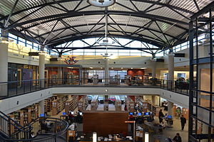
Aurora Public Library (Ontario)
Distance: Approx. 2993 meters
Latitude and longitude: 43.99694444,-79.46666667
The Aurora Public Library is located in Aurora, Ontario, Canada. The library has a collection of more than 150,000 items and has over 31,000 registered users.
Vandorf, Ontario
Unincorporated community in Ontario, Canada
Distance: Approx. 3186 meters
Latitude and longitude: 44.00138889,-79.39166667
Vandorf is a hamlet located in the town of Whitchurch–Stouffville, Ontario, in Canada. It is the most westerly settlement within the Town of Whitchurch-Stouffville. With a population of approximately 722, Vandorf consists mainly of estate residential homes and farms.
Wesley Corners, Ontario
Unincorporated community in Ontario, Canada
Distance: Approx. 3086 meters
Latitude and longitude: 44.01638889,-79.39583333
Wesley Corners is a community situated in the Town of Whitchurch–Stouffville, Ontario, Canada. The hamlet is located at the intersection of Woodbine Avenue (east of Highway 404) and York Regional Road 15/ Aurora Road. It was originally known as Hacking's Corners, after Rev.
St. Maximillian Kolbe Catholic High School
High school in Aurora, Ontario, Canada
Distance: Approx. 1856 meters
Latitude and longitude: 44.00337,-79.45414
St. Maximillian Kolbe Catholic High School is a high school in Aurora, Ontario, Canada. The school opened in September 2009, and is administered by the York Catholic District School Board.
Newmarket—Aurora (provincial electoral district)
Provincial electoral district in Ontario, Canada
Distance: Approx. 2818 meters
Latitude and longitude: 44.027,-79.449
Newmarket—Aurora is a provincial electoral district in Ontario, Canada, that has been represented in the Legislative Assembly of Ontario since 2007. The district contains the towns of Newmarket and Aurora. The riding was created for the 2004 federal election by merging 50% of the riding of York North with 24% of the riding of Vaughan—King—Aurora.

Vandorf Sideroad CNR Bridge
Distance: Approx. 3305 meters
Latitude and longitude: 43.9976,-79.3912
The Vandorf Sideroad CNR Bridge is a railway bridge in the community of Vandorf, in the town of Whitchurch-Stouffville, Ontario, Canada. The bridge carries the line known as the Canadian National Railway Bala Subdivision and crosses Woodbine Avenue diagonally at Vandorf Sideroad. The concrete bridge abutments were built in 1950, and the builder's plate on the bridge confirms the steel deck was constructed in 1952 by the Central Bridge Company in Trenton, Ontario.

Aurora Radial Railway Bridge Abutment
Distance: Approx. 3569 meters
Latitude and longitude: 43.9821,-79.462
The Aurora Radial Railway Bridge Abutment is all that remains of a bridge that was built across the Grand Trunk Railway line in 1899 as part of the Metropolitan Street Railway Company which built its radial line from Toronto along Yonge Street through Aurora, ending at Lake Simcoe. The bridge was removed in 1922 when radial tracks were relocated to share the Yonge Street underpass under the Grand Trunk Railway line. The radial line eventually closed in 1930 with the tracks removed the following year.
Weather in this IP's area
clear sky
16 Celsius
16 Celsius
15 Celsius
18 Celsius
1014 hPa
82 %
1014 hPa
982 hPa
10000 meters
0.86 m/s
0.96 m/s
154 degree
07:02:01
19:20:46