Country:
 USA
USARegion:
City:
Latitude and Longitude:
Time Zone:
Postal Code:
IP information under different IP Channel
ip-api
Country
Region
City
ASN
Time Zone
ISP
Blacklist
Proxy
Latitude
Longitude
Postal
Route
IPinfo
Country
Region
City
ASN
Time Zone
ISP
Blacklist
Proxy
Latitude
Longitude
Postal
Route
MaxMind
Country
Region
City
ASN
Time Zone
ISP
Blacklist
Proxy
Latitude
Longitude
Postal
Route
Luminati
Country
USRegion
nc
City
sapphire
ASN
Time Zone
America/New_York
ISP
MORRISBB
Latitude
Longitude
Postal
db-ip
Country
Region
City
ASN
Time Zone
ISP
Blacklist
Proxy
Latitude
Longitude
Postal
Route
ipdata
Country
Region
City
ASN
Time Zone
ISP
Blacklist
Proxy
Latitude
Longitude
Postal
Route
Popular places and events near this IP address

Gorges State Park
State park in North Carolina, United States
Distance: Approx. 7371 meters
Latitude and longitude: 35.07,-82.92111111
Gorges State Park is a 7,709-acre (31.20 km2) North Carolina state park in Transylvania County, North Carolina in the United States and along with other conservation lands is part of a 100,000+ acre conservation corridor stretching some 80 miles along the NC/SC state line. The land, along Jocassee Gorges, was purchased by the state from Duke Energy Corporation in 1999. It is North Carolina's westernmost state park and one of the state's newest.

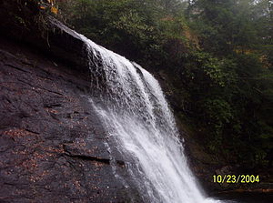
Upper Whitewater Falls
Waterfall in Jackson County / Transylvania County, in the Blue Ridge Mountains of North Carolina
Distance: Approx. 3711 meters
Latitude and longitude: 35.035825,-83.017544
Upper Whitewater Falls is a waterfall in North Carolina on the Whitewater River. As with most of North Carolina's waterfalls, it is in the mountainous area of the state. There is a cluster of falls in the area where the borders of Georgia and the Carolinas come together.
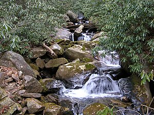
Silver Run Falls
Distance: Approx. 5786 meters
Latitude and longitude: 35.0662,-83.0654
Silver Run Falls is a 20-foot waterfall a few miles from the town of Cashiers, North Carolina. It is popular with locals and tourists alike. The falls are located after a flat, 200 yard trail.

Mordecai Zachary House
Historic house in North Carolina, United States
Distance: Approx. 7691 meters
Latitude and longitude: 35.09111111,-83.08083333
The Zachary-Tolbert House, also known as the Mordecai Zachary House, is a restored pre-American Civil War house located at Cashiers, Jackson County, North Carolina. The house was built between 1850 and 1852, and is a two-story, five bay Greek Revival style frame dwelling. It has a low hipped roof and central front, two-story, portico.
Horsepasture River
Stream in North Carolina, USA
Distance: Approx. 8727 meters
Latitude and longitude: 35.03,-82.91722222
The Horsepasture River is an 18.1-mile-long (29.1 km) National Wild and Scenic river in the U.S. states of North Carolina and South Carolina. The river rises in Jackson County, North Carolina, and flows through the Jocassee Gorges area and ends at Lake Jocassee in South Carolina. Some of the land over which the river flows is part of the Pisgah National Forest, making it accessible to the public.
Foothills Trail
Long-distance hiking trail in the United States
Distance: Approx. 7379 meters
Latitude and longitude: 35.01287,-83.04931
The Foothills Trail is a 76-mile (122 km) National Recreation Trail in South and North Carolina, United States, for recreational hiking and backpacking. It extends from Table Rock State Park to Oconee State Park. It passes through the Andrew Pickens Ranger District of the Sumter National Forest, Ellicott Rock Wilderness, Whitewater Falls, and Lake Jocassee.
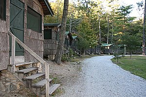
Camp Merrie-Woode
Historic district in North Carolina, United States
Distance: Approx. 8328 meters
Latitude and longitude: 35.13305556,-83.04388889
Camp Merrie-Woode is a non-profit residential camp for girls ages 7–17 in the western hills of North Carolina with a history started in 1919. The camp resides beneath Old Bald [1] and alongside Fairfield Lake in Jackson County. In 2005 there were twenty-eight U.S. states and four foreign countries represented with 85% of campers returning the following summer.
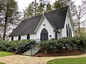
Church of the Good Shepherd (Cashiers, North Carolina)
Historic church in North Carolina, United States
Distance: Approx. 8313 meters
Latitude and longitude: 35.09694444,-83.08527778
The Church of the Good Shepherd is a historic Episcopal church located at 1448 Highway 107 South in Cashiers, Jackson County, North Carolina. It was built about 1895, and is a Gothic Revival style rectangular frame church. It is sheathed in weatherboard and has a steeply pitched roof.
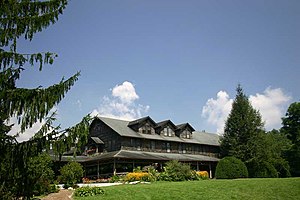
High Hampton Inn Historic District
Historic district in North Carolina, United States
Distance: Approx. 8175 meters
Latitude and longitude: 35.09888889,-83.0825
The High Hampton Inn Historic District is a historic estate, resort, and national historic district nestled in the mountains of western North Carolina, in the Cashiers Valley in Jackson County, North Carolina. Originally the summer home of the prosperous Hampton family of South Carolina, the property was listed on the National Register of Historic Places in 1991. Wealthy planter Wade Hampton II purchased 450 acres (180 ha) in Cashiers Valley as an escape from the summer heat, humidity, and malaria of the Charleston and Columbia, South Carolina region.

Fairfield Inn (Cashiers, North Carolina)
United States historic place
Distance: Approx. 7464 meters
Latitude and longitude: 35.12444444,-83.04333333
The Fairfield Inn was an historic hotel building located on Fairfield Lake near US Highway 64 in Cashiers, Jackson County, North Carolina. It was built in 1896-1898, and consisted of a 2 1/2-story main block with two rear wings. The Queen Anne style frame building featured three massive singled gables, hipped dormers, a three-story corner turret, elliptical windows, and a one-story lakeside verandah.

Bad Creek Hydroelectric Station
Dam in near Salem, South Carolina
Distance: Approx. 6706 meters
Latitude and longitude: 35.00666667,-82.99444444
The Bad Creek Hydroelectric Station is a pumped-storage hydroelectric power station located 8 miles (13 km) north of Salem in Oconee County, South Carolina. The 1,065 megawatts (1,428,000 hp) power plant is owned by Duke Energy and its last generator was commissioned in 1991. The power station generates electricity by shifting water between an upper and lower reservoir.
Sapphire, North Carolina
Unincorporated community in North Carolina, United States
Distance: Approx. 4492 meters
Latitude and longitude: 35.10694444,-83.00305556
Sapphire is an unincorporated community in Transylvania County, North Carolina, United States. Sapphire is 8.5 miles (13.7 km) east of Cashiers. Sapphire has a post office with ZIP code 28774.
Weather in this IP's area
overcast clouds
24 Celsius
24 Celsius
22 Celsius
26 Celsius
1013 hPa
66 %
1013 hPa
914 hPa
10000 meters
0.93 m/s
0.76 m/s
233 degree
100 %
07:18:10
19:33:10