Country:
Region:
City:
Latitude and Longitude:
Time Zone:
Postal Code:
IP information under different IP Channel
ip-api
Country
Region
City
ASN
Time Zone
ISP
Blacklist
Proxy
Latitude
Longitude
Postal
Route
Luminati
Country
Region
nc
City
nebo
ASN
Time Zone
America/New_York
ISP
MORRISBB
Latitude
Longitude
Postal
IPinfo
Country
Region
City
ASN
Time Zone
ISP
Blacklist
Proxy
Latitude
Longitude
Postal
Route
db-ip
Country
Region
City
ASN
Time Zone
ISP
Blacklist
Proxy
Latitude
Longitude
Postal
Route
ipdata
Country
Region
City
ASN
Time Zone
ISP
Blacklist
Proxy
Latitude
Longitude
Postal
Route
Popular places and events near this IP address

McDowell County, North Carolina
County in North Carolina, United States
Distance: Approx. 2698 meters
Latitude and longitude: 35.68,-82.05
McDowell County is a county located in the U.S. state of North Carolina. As of the 2020 census, the population was 44,578. Its county seat is Marion.

Marion, North Carolina
City in North Carolina, United States
Distance: Approx. 1994 meters
Latitude and longitude: 35.6775,-82.00138889
Marion is a city in and the county seat of McDowell County, North Carolina, United States. Founded in 1844, the city was named in honor of Brigadier General Francis Marion, the American Revolutionary War Hero whose talent in guerrilla warfare earned him the name "Swamp Fox". Marion's Main Street Historic District is listed on the National Register of Historic Places.
McDowell High School (Marion, North Carolina)
American public school in North Carolina
Distance: Approx. 2380 meters
Latitude and longitude: 35.7004012,-82.0401097
McDowell High School is a public high school located in the Western North Carolina town of Marion. The school has approximately 1,700–1,800 students. It is the only high school in McDowell County.
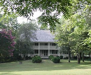
Carson House (Marion, North Carolina)
Historic house in North Carolina, United States
Distance: Approx. 3366 meters
Latitude and longitude: 35.69166667,-82.0575
The Carson House is a historic house and museum located in Marion, North Carolina. It was the home of Col. John Hazzard Carson, and served as the McDowell County courthouse when the county was first organized in 1842.
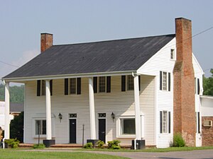
Joseph McDowell House
Building in Marion, North Carolina
Distance: Approx. 2526 meters
Latitude and longitude: 35.70552778,-82.03458333
The Joseph McDowell House is a historic house and museum located in Marion, McDowell County, North Carolina. It was the home of Colonel Joseph "Pleasant Gardens" McDowell, the founder and namesake of McDowell County. It is currently undergoing extensive renovations, and is closed to the public.

Main Street Historic District (Marion, North Carolina)
Historic district in North Carolina, United States
Distance: Approx. 1029 meters
Latitude and longitude: 35.68444444,-82.00972222
The Main Street Historic District is a 21-acre (8.5 ha) national historic district located at Marion, McDowell County, North Carolina. It was listed on the National Register of Historic Places in 1991. In 1991, it included 36 buildings deemed to contribute to the historic character of the area and one other contributing site.
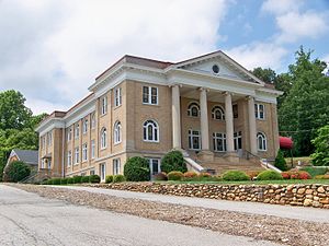
First Presbyterian Church (Marion, North Carolina)
Historic church in North Carolina, United States
Distance: Approx. 763 meters
Latitude and longitude: 35.68416667,-82.01277778
First Presbyterian Church is a historic Presbyterian church located at 12 W. Fort Streets in Marion, McDowell County, North Carolina. The congregation was established in 1845, and the current church building was constructed in 1923. It is a one-story plus balcony Classical Revival style brick building set on a raised basement.
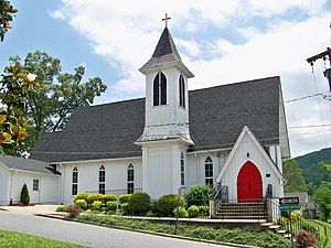
St. John's Episcopal Church (Marion, North Carolina)
Historic church in North Carolina, United States
Distance: Approx. 1420 meters
Latitude and longitude: 35.68,-82.00694444
St. John's Episcopal Church is a historic Episcopal church located at 315 S. Main Street in Marion, McDowell County, North Carolina. It was built in 1883, and is a one-story, Carpenter Gothic style frame church.

St. Matthew's Lutheran Church
Historic church in North Carolina, United States
Distance: Approx. 802 meters
Latitude and longitude: 35.6825,-82.01305556
St. Matthew's Lutheran Church is a historic Lutheran church located at 307 W. Court Street in Marion, McDowell County, North Carolina. It was built in 1935 and is a one-story, vernacular Late Gothic Revival-style church constructed with river rocks.

McDowell County Courthouse (North Carolina)
United States historic place
Distance: Approx. 1113 meters
Latitude and longitude: 35.68388889,-82.00888889
McDowell County Courthouse is a historic courthouse building located at Marion, McDowell County, North Carolina. It was designed by architect Erle G. Stillwell and built between 1921 and 1923. It is three-story, late Neoclassical building sheathed in yellow brick.

Lone Beech
Historic house in North Carolina, United States
Distance: Approx. 720 meters
Latitude and longitude: 35.68527778,-82.01305556
Lone Beech is a historic home located at Marion, McDowell County, North Carolina. It was built between about 1912 and 1915. It is two-story, Neoclassical style dwelling with a broad pedimented two-story ell.
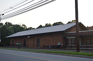
Depot Historic District (Marion, North Carolina)
Historic district in North Carolina, United States
Distance: Approx. 1074 meters
Latitude and longitude: 35.68111111,-82.01055556
Depot Historic District is a national historic district located at Marion, McDowell County, North Carolina. The district encompasses five contributing buildings associated with the Southern Railway depot at Marion. The buildings date from about 1894 to about 1935.
Weather in this IP's area
broken clouds
19 Celsius
19 Celsius
18 Celsius
21 Celsius
1024 hPa
42 %
1024 hPa
974 hPa
10000 meters
1.34 m/s
4.47 m/s
32 degree
72 %
06:58:30
17:25:30