Country:
 USA
USARegion:
City:
Latitude and Longitude:
Time Zone:
Postal Code:
IP information under different IP Channel
ip-api
Country
Region
City
ASN
Time Zone
ISP
Blacklist
Proxy
Latitude
Longitude
Postal
Route
IPinfo
Country
Region
City
ASN
Time Zone
ISP
Blacklist
Proxy
Latitude
Longitude
Postal
Route
MaxMind
Country
Region
City
ASN
Time Zone
ISP
Blacklist
Proxy
Latitude
Longitude
Postal
Route
Luminati
Country
USRegion
nc
City
nebo
ASN
Time Zone
America/New_York
ISP
MORRISBB
Latitude
Longitude
Postal
db-ip
Country
Region
City
ASN
Time Zone
ISP
Blacklist
Proxy
Latitude
Longitude
Postal
Route
ipdata
Country
Region
City
ASN
Time Zone
ISP
Blacklist
Proxy
Latitude
Longitude
Postal
Route
Popular places and events near this IP address

Marion, North Carolina
City in North Carolina, United States
Distance: Approx. 8754 meters
Latitude and longitude: 35.6775,-82.00138889
Marion is a city in and the county seat of McDowell County, North Carolina, United States. Founded in 1844, the city was named in honor of Brigadier General Francis Marion, the American Revolutionary War Hero whose talent in guerrilla warfare earned him the name "Swamp Fox". Marion's Main Street Historic District is listed on the National Register of Historic Places.

Lake James State Park
State park in Burke and McDowell Counties, North Carolina
Distance: Approx. 6604 meters
Latitude and longitude: 35.73388889,-81.88916667
Lake James State Park is a North Carolina state park in Burke and McDowell counties, North Carolina in the United States. Located near Nebo, North Carolina, it covers 3,743 acres (15.15 km2) and borders 6,510-acre (26 km2) Lake James.
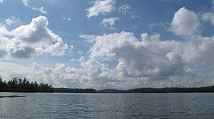
Lake James
Reservoir in North Carolina, United States
Distance: Approx. 7725 meters
Latitude and longitude: 35.74333333,-81.88444444
Lake James is a large reservoir in the mountains of Western North Carolina which straddles the border between Burke and McDowell Counties. It is named for tobacco tycoon and benefactor of Duke University James Buchanan Duke. The lake, with surface elevation of 1200 ft (366 m), lies behind a series of 4 earthen dams.
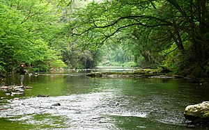
Linville River
River in North Carolina, United States
Distance: Approx. 9690 meters
Latitude and longitude: 35.74305556,-81.83638889
The Linville River is a river in western North Carolina, United States. The river begins in the slopes of Peak Mountain, Sugar Mountain and Flattop Mountain, in the Linville Gap area (also known as Tynecastle). As it goes south through Avery County, it passes through the communities of Grandfather, Linville, Pineola, Crossnore and finally at Linville Falls.
Nebo, North Carolina
Census-designated place in North Carolina, United States
Distance: Approx. 4969 meters
Latitude and longitude: 35.715,-81.93111
Nebo is an unincorporated community and census-designated place (CDP) in the Nebo Township of eastern McDowell County, North Carolina, United States. It was first listed as a CDP in the 2020 census with a population of 1,790.

Main Street Historic District (Marion, North Carolina)
Historic district in North Carolina, United States
Distance: Approx. 9553 meters
Latitude and longitude: 35.68444444,-82.00972222
The Main Street Historic District is a 21-acre (8.5 ha) national historic district located at Marion, McDowell County, North Carolina. It was listed on the National Register of Historic Places in 1991. In 1991, it included 36 buildings deemed to contribute to the historic character of the area and one other contributing site.
First Presbyterian Church (Marion, North Carolina)
Historic church in North Carolina, United States
Distance: Approx. 9825 meters
Latitude and longitude: 35.68416667,-82.01277778
First Presbyterian Church is a historic Presbyterian church located at 12 W. Fort Streets in Marion, McDowell County, North Carolina. The congregation was established in 1845, and the current church building was constructed in 1923. It is a one-story plus balcony Classical Revival style brick building set on a raised basement.
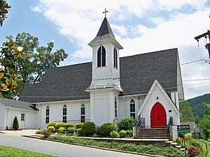
St. John's Episcopal Church (Marion, North Carolina)
Historic church in North Carolina, United States
Distance: Approx. 9266 meters
Latitude and longitude: 35.68,-82.00694444
St. John's Episcopal Church is a historic Episcopal church located at 315 S. Main Street in Marion, McDowell County, North Carolina. It was built in 1883, and is a one-story, Carpenter Gothic style frame church.

St. Matthew's Lutheran Church
Historic church in North Carolina, United States
Distance: Approx. 9835 meters
Latitude and longitude: 35.6825,-82.01305556
St. Matthew's Lutheran Church is a historic Lutheran church located at 307 W. Court Street in Marion, McDowell County, North Carolina. It was built in 1935 and is a one-story, vernacular Late Gothic Revival-style church constructed with river rocks.
Glenwood, North Carolina
Census-designated place in North Carolina, United States
Distance: Approx. 9730 meters
Latitude and longitude: 35.61611111,-81.98305556
Glenwood is an unincorporated community and census-designated place in McDowell County, North Carolina, United States, with a rich musical heritage. It was first listed as a CDP in the 2020 census with a population of 501. Glenwood is located along U.S. Route 221, 5 miles (8.0 km) south-southeast of Marion.

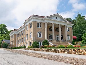
McDowell County Courthouse (North Carolina)
United States historic place
Distance: Approx. 9472 meters
Latitude and longitude: 35.68388889,-82.00888889
McDowell County Courthouse is a historic courthouse building located at Marion, McDowell County, North Carolina. It was designed by architect Erle G. Stillwell and built between 1921 and 1923. It is three-story, late Neoclassical building sheathed in yellow brick.
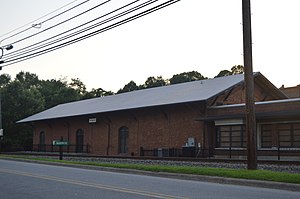
Depot Historic District (Marion, North Carolina)
Historic district in North Carolina, United States
Distance: Approx. 9599 meters
Latitude and longitude: 35.68111111,-82.01055556
Depot Historic District is a national historic district located at Marion, McDowell County, North Carolina. The district encompasses five contributing buildings associated with the Southern Railway depot at Marion. The buildings date from about 1894 to about 1935.
Weather in this IP's area
broken clouds
27 Celsius
28 Celsius
25 Celsius
28 Celsius
1012 hPa
64 %
1012 hPa
971 hPa
10000 meters
1.34 m/s
3.13 m/s
73 %
07:13:40
19:28:54