Country:
 USA
USARegion:
City:
Latitude and Longitude:
Time Zone:
Postal Code:
IP information under different IP Channel
ip-api
Country
Region
City
ASN
Time Zone
ISP
Blacklist
Proxy
Latitude
Longitude
Postal
Route
IPinfo
Country
Region
City
ASN
Time Zone
ISP
Blacklist
Proxy
Latitude
Longitude
Postal
Route
MaxMind
Country
Region
City
ASN
Time Zone
ISP
Blacklist
Proxy
Latitude
Longitude
Postal
Route
Luminati
Country
USASN
Time Zone
America/Chicago
ISP
TVC-AS1
Latitude
Longitude
Postal
db-ip
Country
Region
City
ASN
Time Zone
ISP
Blacklist
Proxy
Latitude
Longitude
Postal
Route
ipdata
Country
Region
City
ASN
Time Zone
ISP
Blacklist
Proxy
Latitude
Longitude
Postal
Route
Popular places and events near this IP address

Bellows Falls, Vermont
Village in Vermont, United States
Distance: Approx. 147 meters
Latitude and longitude: 43.13333333,-72.44388889
Bellows Falls is an incorporated village located in the town of Rockingham in Windham County, Vermont, United States. The population was 2,747 at the 2020 census. Bellows Falls is home to the Green Mountain Railroad, a heritage railroad; the annual Roots on the River Festival; and the No Film Film Festival.

Bellows Falls station
Railroad station in Bellows Falls, Vermont, US
Distance: Approx. 202 meters
Latitude and longitude: 43.136407,-72.444657
Bellows Falls station is an Amtrak intercity rail station located in the Bellows Falls village of Rockingham, Vermont, United States. The station is served by the single daily round trip of the Washington, D.C.–St. Albans Vermonter.
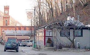
Miss Bellows Falls Diner
United States historic place
Distance: Approx. 256 meters
Latitude and longitude: 43.135,-72.4475
Miss Bellows Falls Diner is a historic diner at 90 Rockingham Street in Bellows Falls, Vermont. The diner was constructed in 1941 by the Worcester Lunch Car Company as #771, and was listed on the National Register of Historic Places in 1983.

Bellows Falls Tunnel
Railroad tunnel in Vermont
Distance: Approx. 118 meters
Latitude and longitude: 43.133662,-72.443729
The Bellows Falls Tunnel is a railroad tunnel located in center of the Village of Bellows Falls within the Town of Rockingham, Vermont, adjacent to the Connecticut River, and is currently owned and operated by the New England Central Railroad (NECR). The Vermont Valley Railroad originally constructed the tunnel in 1851. Partially cut through solid rock, the tunnel was built with rough-cut stone blocks, where each portal was decorated with radiating voussoirs around their horseshoe shaped arches.
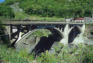
Vilas Bridge
Bridge in Vermont and North Walpole, New Hampshire
Distance: Approx. 343 meters
Latitude and longitude: 43.13527778,-72.44027778
The Charles N. Vilas Bridge is a 635-foot (194 m) two-span concrete deck arch bridge over the Connecticut River between Bellows Falls, Vermont, and North Walpole, New Hampshire. It was built in 1930 and has been closed since March 19, 2009. The state of New Hampshire has budgeted funds to repair the bridge, with work scheduled to begin in 2028.

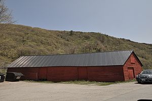
Bellows Falls Co-operative Creamery Complex
United States historic place
Distance: Approx. 253 meters
Latitude and longitude: 43.13622222,-72.44222222
The Bellows Falls Co-operative Creamery Complex is a historic industrial property in Bellows Falls, Vermont. Developed over a period of about 40 years beginning c. 1906, the complex, with two surviving buildings, it represents one of Vermont's largest commercial enterprises of the period.

Bellows Falls Times Building
United States historic place
Distance: Approx. 143 meters
Latitude and longitude: 43.13463889,-72.44263889
The Bellows Falls Times Building is a historic newspaper plant on Bridge and Island Streets in Bellows Falls, Vermont. The complex of three buildings was developed in the 1930s by the Vermont Newspaper Corporation, and served as home for the Bellows Falls Times newspaper until 1965, when it was consolidated with other local newspapers. The main building is a particularly fine local example of Colonial Revival design.
Howard Hardware Storehouse
United States historic place
Distance: Approx. 321 meters
Latitude and longitude: 43.13583333,-72.44083333
The Howard Hardware Storehouse is a historic storage building off Bridge Street in Bellows Falls, Vermont. Built about 1895, it is a surviving reminder of the city's railroad-related economic past, built in a distinctive tetrahedral shape to accommodate nearby railroad lines. It was listed on the National Register of Historic Places in 1990.

Robertson Paper Company Complex
United States historic place
Distance: Approx. 162 meters
Latitude and longitude: 43.13583333,-72.44333333
The Robertson Paper Company Complex was a historic industrial facility on Island Street in Bellows Falls, Vermont. It consisted of a collection of mostly-interconnected factory and related buildings, built between c. 1890 and c.

Moore and Thompson Paper Mill Complex
United States historic place
Distance: Approx. 190 meters
Latitude and longitude: 43.13361111,-72.4425
The Moore and Thompson Paper Mill Complex is a major late 19th-century industrial site off Bridge Street in Bellows Falls, Vermont. It is the largest surviving mill complex from the village's industrial heyday, and is one of the largest of the period in the state. It was listed on the National Register of Historic Places in 1984.
Immanuel Episcopal Church (Bellows Falls, Vermont)
Church building in Bellows Falls, Vermont
Distance: Approx. 131 meters
Latitude and longitude: 43.133725,-72.4454799
The present Immanuel Episcopal Church was finished in Bellows Falls in Vermont in 1869 and was designed by the renowned Gothic revival architect Richard M. Upjohn. The building's Gothic style would have been typical of 14th-century France. The multi-colored fish scale slate roof is typical of the Victorian Gothic style of architecture.

Bellows Falls Canal
Canal in Bellows Falls, Vermont, U.S.
Distance: Approx. 23 meters
Latitude and longitude: 43.13472222,-72.44416667
Bellows Falls Canal is a canal constructed to allow boat traffic to bypass Great Falls on the Connecticut River in Bellows Falls, Vermont. It was constructed by the Bellows Falls Canal Company and was one of the first canals in the United States. It was used for transport, to power mills, and later for hydroelectric power.
Weather in this IP's area
scattered clouds
15 Celsius
15 Celsius
14 Celsius
17 Celsius
1008 hPa
88 %
1008 hPa
999 hPa
10000 meters
0.89 m/s
3.13 m/s
306 degree
42 %
06:54:21
18:20:17