216.110.205.96 - IP Lookup: Free IP Address Lookup, Postal Code Lookup, IP Location Lookup, IP ASN, Public IP
Country:
 USA
USARegion:
City:
Location:
Time Zone:
Postal Code:
ISP:
ASN:
language:
User-Agent:
Proxy IP:
Blacklist:
IP information under different IP Channel
ip-api
Country
Region
City
ASN
Time Zone
ISP
Blacklist
Proxy
Latitude
Longitude
Postal
Route
db-ip
Country
Region
City
ASN
Time Zone
ISP
Blacklist
Proxy
Latitude
Longitude
Postal
Route
IPinfo
Country
Region
City
ASN
Time Zone
ISP
Blacklist
Proxy
Latitude
Longitude
Postal
Route
IP2Location
216.110.205.96Country
usRegion
oregon
City
florence
Time Zone
America/Los_Angeles
ISP
Language
User-Agent
Latitude
Longitude
Postal
ipdata
Country
Region
City
ASN
Time Zone
ISP
Blacklist
Proxy
Latitude
Longitude
Postal
Route
Popular places and events near this IP address
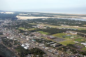
Florence, Oregon
City in Oregon, United States
Distance: Approx. 6508 meters
Latitude and longitude: 43.975,-124.1025
Florence is a coastal city in Lane County, in the U.S. state of Oregon. It lies at the mouth of the Siuslaw River on the Pacific Ocean and about midway between Newport to the north and Coos Bay to the south along U.S. Route 101. As of August 14, 2023, the city had a total population of 9,553.
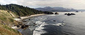
Oregon Coast
Coastal region of the U.S. state of Oregon
Distance: Approx. 5196 meters
Latitude and longitude: 44,-124.1
The Oregon Coast is a coastal region of the U.S. state of Oregon. It is bordered by the Pacific Ocean to its west and the Oregon Coast Range to the east, and stretches approximately 362 miles (583 km) from the California state border in the south to the Columbia River in the north. The region is not a specific geological, environmental, or political entity, and includes the Columbia River Estuary.

Darlingtonia State Natural Site
Botanical preserve in Oregon
Distance: Approx. 6326 meters
Latitude and longitude: 44.0459549,-124.0962302
Darlingtonia State Natural Site (18 acres) is a state park and botanical preserve located five miles (8.0 km) north of Florence, Oregon, United States on U.S. Route 101, just west of Mercer Lake and south of Sutton Lake that is dedicated to the preservation of a rare plant. Darlingtonia californica is a carnivorous plant (commonly known as the cobra lily or western pitcher plant), luring and trapping insects to its hollow, vertical pitchers (leaves) with a sweet, sticky secretion. In addition to the aroma, the top of the pitcher is red and attracts specific insects by the bright color.

Florence Municipal Airport
Airport in Florence, Oregon
Distance: Approx. 6676 meters
Latitude and longitude: 43.98281667,-124.11136944
Florence Municipal Airport (IATA: FMU, FAA LID: 6S2), is a public airport located in the city of Florence in Lane County, Oregon, United States. It is mostly used for general aviation.

KCFM (AM)
Radio station in Florence, Oregon
Distance: Approx. 5353 meters
Latitude and longitude: 44.02916667,-124.09694444
KCFM (1250 AM) is a radio station broadcasting an Adult Standards/MOR format. Licensed to Florence, Oregon, United States, the station serves the Central Oregon coast area. The station is currently owned by Coast Broadcasting Company and features programming from ABC Radio.
KCST-FM
Radio station in Florence, Oregon
Distance: Approx. 6686 meters
Latitude and longitude: 43.95527778,-124.07388889
KCST-FM (106.9 FM) is a radio station broadcasting an Adult Contemporary format. Licensed to Florence, Oregon, United States, the station serves the central Oregon Coast. The station is currently owned by Coast Broadcasting Co., Inc.
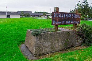
Siuslaw High School
High school in Oregon
Distance: Approx. 5890 meters
Latitude and longitude: 43.992,-124.106
Siuslaw High School is a public high school in the northwest United States, located in Florence, Oregon. It is named after the local Siuslaw River, and the current principal is Michael Harklerode.
Sandpines Golf Links
Public golf course in Oregon, United States
Distance: Approx. 5896 meters
Latitude and longitude: 44.00277778,-124.10944444
Sandpines Golf Links is a public golf course in Florence, Oregon, United States, on the central Oregon Coast.
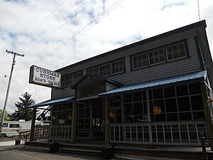
Cushman, Oregon
Unincorporated community in the state of Oregon, United States
Distance: Approx. 2674 meters
Latitude and longitude: 43.98555556,-124.04416667
Cushman is an unincorporated community in Lane County, Oregon, United States. It is located on the north bank of the Siuslaw River on Oregon Route 126, between Tiernan and Florence. Cushman was a station on the Coos Bay Branch of the Southern Pacific Railroad (today the Coos Bay Rail Link), named for local residents C. C. and I. B. Cushman.

Edwin E. Benedict House
Historic house in Oregon, United States
Distance: Approx. 4481 meters
Latitude and longitude: 43.975279,-124.067069
The Edwin E. Benedict House was a historic house located on Cox Island in the Siuslaw River, near Florence, Oregon, United States. The house was listed on the National Register of Historic Places in 1979.
Bernhardt Creek
Stream in Lane County, Oregon, U.S.
Distance: Approx. 2830 meters
Latitude and longitude: 43.98861111,-124.015
Bernhardt Creek is a stream in Lane County, Oregon, in the United States. The creek was named for the Bernhardt family of early settlers. It flows mostly west-northwest to its mouth at the Siuslaw River about 4.5 miles (7.2 km) east of Florence.

North Fork Siuslaw River
River in Oregon, the United States of America
Distance: Approx. 5081 meters
Latitude and longitude: 43.97638889,-124.08083333
The North Fork Siuslaw River is a tributary of the Siuslaw River in Lane County in the United States state of Oregon. It is formed by the confluence of Sam Creek and West Branch in the Siuslaw National Forest of the Central Oregon Coast Range. The former community of Pawn was once at the juncture of the two creeks.
Weather in this IP's area
few clouds
1 Celsius
1 Celsius
1 Celsius
2 Celsius
1029 hPa
100 %
1029 hPa
1013 hPa
10000 meters
0.45 m/s
1.79 m/s
139 degree
24 %