Country:
Region:
City:
Latitude and Longitude:
Time Zone:
Postal Code:
IP information under different IP Channel
ip-api
Country
Region
City
ASN
Time Zone
ISP
Blacklist
Proxy
Latitude
Longitude
Postal
Route
Luminati
Country
Region
fl
City
jacksonville
ASN
Time Zone
America/New_York
ISP
VYSTARCU
Latitude
Longitude
Postal
IPinfo
Country
Region
City
ASN
Time Zone
ISP
Blacklist
Proxy
Latitude
Longitude
Postal
Route
db-ip
Country
Region
City
ASN
Time Zone
ISP
Blacklist
Proxy
Latitude
Longitude
Postal
Route
ipdata
Country
Region
City
ASN
Time Zone
ISP
Blacklist
Proxy
Latitude
Longitude
Postal
Route
Popular places and events near this IP address
Duval County, Florida
County in Florida, United States
Distance: Approx. 80 meters
Latitude and longitude: 30.33,-81.65
Duval County ( dew-VAWL), officially the City of Jacksonville and Duval County, is a county in the northeastern part of the U.S. state of Florida. As of July 2022, the population was 1,016,536, up from 864,263 in 2010. It is Florida's sixth-most populous county.

VyStar Veterans Memorial Arena
Arena in Jacksonville, Florida, United States
Distance: Approx. 599 meters
Latitude and longitude: 30.32576944,-81.64506944
VyStar Veterans Memorial Arena (originally Jacksonville Veterans Memorial Arena) is a multi-purpose arena located in Jacksonville, Florida. It currently serves as the home arena of the Jacksonville Icemen of the ECHL, the Jacksonville Giants of the American Basketball Association, and the Jacksonville Sharks of the Indoor Football League.

Jacksonville Sheriff's Office
Joint city-county law enforcement agency
Distance: Approx. 567 meters
Latitude and longitude: 30.325381,-81.652126
The Jacksonville Sheriff's Office (JSO) is a joint city-county law enforcement agency, which has primary responsibility for law enforcement, investigation, and corrections within the consolidated City of Jacksonville and Duval County, Florida, United States. Duval County includes the incorporated cities of Jacksonville, Atlantic Beach, Baldwin, Jacksonville Beach, and Neptune Beach; the beach cities have their own police departments as well.

St. John's Cathedral (Jacksonville)
Church in Florida, United States
Distance: Approx. 422 meters
Latitude and longitude: 30.328772,-81.653423
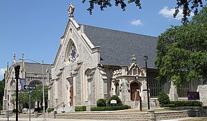
St. John's Cathedral is a cathedral of the Episcopal Church in Jacksonville, Florida, U.S. One of the oldest congregations in Jacksonville, it became the seat of the Bishop of the Episcopal Diocese of Florida in 1951. The current building dates to 1906.
Old St. Luke's Hospital
United States historic place
Distance: Approx. 492 meters
Latitude and longitude: 30.32583333,-81.64694444
The Old St. Luke's Hospital is a historic U.S. hospital in Jacksonville, Florida. It is located at 314 North Palmetto Street.

Morocco Temple
United States historic place
Distance: Approx. 580 meters
Latitude and longitude: 30.3277,-81.65472
The Morocco Temple (also known as the Morocco Temple, Ancient Arabic Order of the Nobles of the Mystic Shrine) is a historic Shriners International building in Jacksonville, Florida. It is located at 219 Newnan Street, and was designed by Jacksonville architect Henry John Klutho. On November 29, 1979, it was added to the U.S. National Register of Historic Places.

Buckman and Ulmer Building
United States historic place
Distance: Approx. 368 meters
Latitude and longitude: 30.32861111,-81.65277778
The Buckman and Ulmer Building was a historic building in Jacksonville, Florida. It was built in 1925 by Jacksonville architects Marsh & Saxelbye for the Buckman and Ulmer Real Estate Company. It was located at 29-33 West Monroe Street.

South Atlantic Investment Corporation Building
United States historic place
Distance: Approx. 319 meters
Latitude and longitude: 30.32861111,-81.65222222
The South Atlantic Investment Corporation Building was a historic building in Jacksonville, Florida, United States. It was built in 1925 for the South Atlantic Investment Corporation, and was located at 35-39 West Monroe Street. On December 30, 1992, it was added to the U.S. National Register of Historic Places.

Basilica of the Immaculate Conception (Jacksonville)
Historic church in Florida, United States
Distance: Approx. 593 meters
Latitude and longitude: 30.32888889,-81.65527778
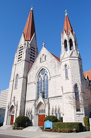
The Basilica of the Immaculate Conception is a historic Catholic church in Downtown Jacksonville, Florida, U.S. A parish church in the Diocese of St. Augustine, it represents Jacksonville's oldest Catholic congregation. The current building, dating to 1910, was added to the U.S. National Register of Historic Places in 1992 as the Church of the Immaculate Conception, and was named a minor basilica in 2013.

Jacksonville Public Library
Public library system in Florida
Distance: Approx. 699 meters
Latitude and longitude: 30.32762,-81.65602
The Jacksonville Public Library is the public library system of Jacksonville, Florida, United States. It primarily serves Jacksonville and Duval County merged areas, and is also used by the neighboring Baker, Nassau, Clay, and St. Johns counties.

Episcopal Diocese of Florida
Diocese of the Episcopal Church in the United States
Distance: Approx. 450 meters
Latitude and longitude: 30.3282,-81.6535
The Episcopal Diocese of Florida is a diocese of the Episcopal Church in the United States of America (ECUSA). It originally comprised the whole state of Florida, but is now bounded on the west by the Apalachicola River, on the north by the Georgia state line, on the east by the Atlantic Ocean and on the south by the northern boundaries of Volusia, Marion, and Citrus counties. Its cathedral church is St.
Old City Cemetery (Jacksonville, Florida)
Historic site in Jacksonville, Florida
Distance: Approx. 292 meters
Latitude and longitude: 30.3324,-81.6488
The Old City Cemetery in Jacksonville, Florida was established in 1852 as Jacksonville's main burial ground. After the American Civil War the cemetery later interred many Confederate veterans and veterans of the Union Army’s United States Colored Troops. Because the cemetery is over 160 years old, the Jacksonville Historic Landmarks Commission has deemed it a historic landmark of Jacksonville.
Weather in this IP's area
clear sky
26 Celsius
26 Celsius
25 Celsius
27 Celsius
1015 hPa
78 %
1015 hPa
1015 hPa
10000 meters
4.12 m/s
100 degree
06:46:56
17:33:54


