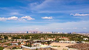
216.107.130.210 - IP Lookup: Free IP Address Lookup, Postal Code Lookup, IP Location Lookup, IP ASN, Public IP
Country:
Region:
City:
Location:
Time Zone:
Postal Code:
IP information under different IP Channel
ip-api
Country
Region
City
ASN
Time Zone
ISP
Blacklist
Proxy
Latitude
Longitude
Postal
Route
Luminati
Country
ASN
Time Zone
America/Chicago
ISP
RH & Co. IT Services Ltd
Latitude
Longitude
Postal
IPinfo
Country
Region
City
ASN
Time Zone
ISP
Blacklist
Proxy
Latitude
Longitude
Postal
Route
IP2Location
216.107.130.210Country
Region
nevada
City
las vegas
Time Zone
America/Los_Angeles
ISP
Language
User-Agent
Latitude
Longitude
Postal
db-ip
Country
Region
City
ASN
Time Zone
ISP
Blacklist
Proxy
Latitude
Longitude
Postal
Route
ipdata
Country
Region
City
ASN
Time Zone
ISP
Blacklist
Proxy
Latitude
Longitude
Postal
Route
Popular places and events near this IP address
Spring Valley, Nevada
Unincorporated town in the State of Nevada, United States
Distance: Approx. 2261 meters
Latitude and longitude: 36.1125,-115.25027778
Spring Valley is an unincorporated town and census-designated place in Clark County, Nevada, United States, located 2 miles (3 km) west of the Las Vegas Strip. The population was 215,597 at the 2020 census. Spring Valley was formed in May 1981.
Spring Valley Hospital
Hospital in Nevada, U.S.
Distance: Approx. 4059 meters
Latitude and longitude: 36.09004,-115.24054
Spring Valley Hospital Medical Center is a for-profit hospital is owned by Universal Health Services and operated by Valley Health System. The 364-bed hospital is located in Spring Valley, Nevada.
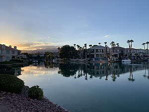
The Lakes, Las Vegas
Distance: Approx. 2784 meters
Latitude and longitude: 36.13666667,-115.28611111
The Lakes is a 2-square-mile (5.2 km2) planned community located within the city limits of Las Vegas, Nevada. It is located in the western part of the Las Vegas Valley near the Spring Mountains and Red Rock Canyon National Conservation Area. The centerpiece of the community, and its namesake, is a large man-made lake, Lake Sahara.
Las Vegas Art Museum
Former art museum in Nevada
Distance: Approx. 4522 meters
Latitude and longitude: 36.14526,-115.30629
The Las Vegas Art Museum was an art museum in Las Vegas, Nevada. It was formerly located in a building shared with the Sahara West Library branch of the Las Vegas-Clark County Library District in Las Vegas, NV. The museum closed in 2009. The Las Vegas Art Museum was "dedicated to engaging visitors in the international culture of contemporary art." The museum provided the public with publications, lectures, educational and outreach programs.
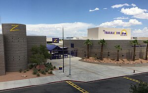
Durango High School (Nevada)
Public school in Las Vegas, Nevada, United States
Distance: Approx. 3751 meters
Latitude and longitude: 36.08872,-115.24674
Durango High School is a public high school in Spring Valley, Nevada, USA, with an enrollment of approximately 2600 students. It is a part of the Area 4 region of the Clark County School District, which is the fifth largest school district in the United States. Durango High School's main sports rivals are Bishop Gorman High School and Spring Valley High School.
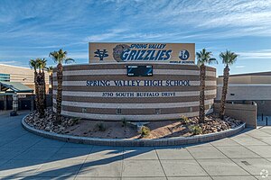
Spring Valley High School (Nevada)
Public high school
Distance: Approx. 1665 meters
Latitude and longitude: 36.12046,-115.25921
Spring Valley High School is located in the Spring Valley community in unincorporated Clark County, Nevada, United States. The school, serving grades 9 through 12, is a part of the Clark County School District. The school's mascot is a grizzly bear.
West Las Vegas
Historic neighborhood in Las Vegas, Nevada, United States
Distance: Approx. 2678 meters
Latitude and longitude: 36.13454,-115.28915
West Las Vegas is a historic neighborhood in Las Vegas, Nevada. This 3.5 sq mi (9.1 km2) area is located northwest of the Las Vegas Strip and the "Spaghetti Bowl" interchange of I-15 and I-11/US 95. It is also known as Historic West Las Vegas and more simply, the Westside.
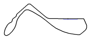
Stardust International Raceway
Former race track
Distance: Approx. 2146 meters
Latitude and longitude: 36.10777778,-115.2525
The Stardust International Raceway was an auto racing track in present-day Spring Valley, Nevada, United States, in the Las Vegas Valley. It featured a flat, 3.000 mi (4.828 km), 13-turn road course, and a quarter-mile drag strip. Some track maps depicted the road course with 10 numbered turns.
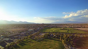
Desert Breeze Park
Park in Spring Valley, Nevada, US
Distance: Approx. 1214 meters
Latitude and longitude: 36.1241,-115.27517
Desert Breeze Park located in Spring Valley, Nevada, is one of the largest parks in the Clark County park system. The regional park is a 240-acre (97 ha) facility that is not fully developed.
Canyon Gate Country Club
Golf club in Nevada, United States
Distance: Approx. 4083 meters
Latitude and longitude: 36.14861111,-115.28722222
Canyon Gate Country Club is a golf club to the west of Las Vegas, Nevada. The 6742 yard course was established in 1989, and was designed by Ted Robinson. It hosted the Las Vegas LPGA in 1993.
The Gramercy
Apartments and commercial in Nevada, United States
Distance: Approx. 3631 meters
Latitude and longitude: 36.084095,-115.293612
The Gramercy is a mixed-use development project in Spring Valley, Nevada, west of the Las Vegas Strip. It includes two office buildings and 160 apartment units. Gemstone Development began construction of the project, originally known as ManhattanWest, in 2007.
Killings of Sydney Land and Nehemiah Kauffman
2016 unsolved double murder
Distance: Approx. 3509 meters
Latitude and longitude: 36.10888889,-115.31405556
On October 26, 2016, Sydney Land and her boyfriend Nehemiah Kauffman were shot and killed in her apartment in Las Vegas, Nevada. Their bodies were found the next day. Initially, Las Vegas Metropolitan Police Department (also known as Metro) announced that they had no motive and no suspects in the case.
Weather in this IP's area
broken clouds
6 Celsius
6 Celsius
5 Celsius
8 Celsius
1023 hPa
41 %
1023 hPa
932 hPa
10000 meters
1.54 m/s
240 degree
75 %
