Country:
 USA
USARegion:
City:
Latitude and Longitude:
Time Zone:
Postal Code:
IP information under different IP Channel
ip-api
Country
Region
City
ASN
Time Zone
ISP
Blacklist
Proxy
Latitude
Longitude
Postal
Route
IPinfo
Country
Region
City
ASN
Time Zone
ISP
Blacklist
Proxy
Latitude
Longitude
Postal
Route
MaxMind
Country
Region
City
ASN
Time Zone
ISP
Blacklist
Proxy
Latitude
Longitude
Postal
Route
Luminati
Country
USASN
Time Zone
America/Chicago
ISP
NAVE-CONX-A
Latitude
Longitude
Postal
db-ip
Country
Region
City
ASN
Time Zone
ISP
Blacklist
Proxy
Latitude
Longitude
Postal
Route
ipdata
Country
Region
City
ASN
Time Zone
ISP
Blacklist
Proxy
Latitude
Longitude
Postal
Route
Popular places and events near this IP address
WUBG (AM)
Radio station in Massachusetts, United States
Distance: Approx. 3070 meters
Latitude and longitude: 42.67397222,-71.19005556
WUBG (1570 kHz) is a regional Mexican station licensed to serve Methuen, Massachusetts. It has an FM translator, W287CW, at 105.3 MHz. The station is called "La Pantera".

WNNW
Radio station in Massachusetts, United States
Distance: Approx. 3069 meters
Latitude and longitude: 42.67398056,-71.19005833
WNNW (800 AM; "Power 800 AM/102.9 FM") is a commercial radio station licensed to Lawrence, Massachusetts, United States. Established in 1947 as WCCM, the station is owned by Costa-Eagle Radio Ventures, LP, a partnership between Pat Costa and the Lawrence Eagle-Tribune newspaper. WNNW airs a Spanish-language tropical music format.
Walnut Grove Cemetery
Historic cemetery in Massachusetts, United States
Distance: Approx. 3378 meters
Latitude and longitude: 42.72305556,-71.19083333
Walnut Grove Cemetery is a historic cemetery at Grove and Railroads Streets in Methuen, Massachusetts. The still active cemetery sits on 14 acres (5.7 ha) and is privately funded with a board of directors. The cemetery was established in 1853, and was laid out in the then-popular rural cemetery style.

Bellevue Cemetery
Historic cemetery in Massachusetts, United States
Distance: Approx. 2574 meters
Latitude and longitude: 42.71055556,-71.18611111
Bellevue Cemetery is a historic cemetery in Lawrence and Methuen, Massachusetts. Established in 1847 and owned by the city of Lawrence, it is the first and principal cemetery of the city and a notable example of a rural cemetery. In conjunction with adjacent cemeteries and Lawrence's High Service Water Tower and Reservoir, it provides part of the small city's largest area of open space.

Arlington Mills Historic District
Historic district in Massachusetts, United States
Distance: Approx. 3241 meters
Latitude and longitude: 42.71555556,-71.18111111
The Arlington Mills Historic District encompasses a major 19th century textile manufacturing complex in Lawrence and Methuen, Massachusetts. Developed between 1865 and 1925, it was one of the state's largest textile operations at its height. At the time of its listing on the National Register of Historic Places in 1985, the mill complex was owned by Malden Mills.

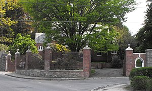
Timothy P. Bailey House
Historic house in Massachusetts, United States
Distance: Approx. 1993 meters
Latitude and longitude: 42.67916667,-71.20638889
The Timothy P. Bailey House is a historic house in Andover, Massachusetts. It was built by Timothy Palmer Bailey, on land purchased from his father's estate. The Baileys were successful farmers, and the younger one, who was educated at Phillips Academy, built this locally rare example of an Italianate house in 1878.

Stephen Barker House
Historic house in Massachusetts, United States
Distance: Approx. 1489 meters
Latitude and longitude: 42.70666667,-71.19916667
Stephen Barker House is a historic house at 165 Haverhill Street in Methuen, Massachusetts. Built in 1839, it is one of several handsome houses built at the periphery of the Methuen settlement in the mid-19th Century, and remains a well conserved "country Residence". Reportedly, surveyor Stephen Barker built "Woodland Cottage" in imitation of antebellum mansions he had seen in the South.

Emerson House (Methuen, Massachusetts)
Historic house in Massachusetts, United States
Distance: Approx. 3437 meters
Latitude and longitude: 42.7075,-71.17194444
The Emerson House is a historic house located at 58 Ayers Village Road in Methuen, Massachusetts. It is set in a rural corner of northeastern Methuen, near the town line with Haverhill.

High Service Water Tower and Reservoir
United States historic place
Distance: Approx. 2550 meters
Latitude and longitude: 42.70722222,-71.18361111
The High Service Water Tower and Reservoir, colloquially known as the Tower Hill Tower, is a public water supply facility off Massachusetts Route 110 in Lawrence, Massachusetts. The reservoir was constructed in 1874–75 to provide the city's public water supply, with a gatehouse designed by Charles T. Emerson, a Lawrence architect. The tower was built in 1896 as a high pressure standpipe or water tower.

The Islamic Academy
Private school in Methuen, , Massachusetts, United States
Distance: Approx. 3015 meters
Latitude and longitude: 42.72,-71.1925
The Islamic Academy for Peace (Arabic: الأكاديمية الإسلامية للسلام ) is a private Islamic elementary and middle school, with grades Daycare, PreK–8 in Methuen, Massachusetts. It had its beginnings in 2001, with a few teachers and a handful of students. Today, the school has grown to have a staff of teachers and over 150 students.
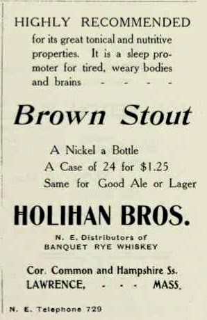
Holihan Brothers
Former brewery in Lawrence, Massachusetts
Distance: Approx. 3352 meters
Latitude and longitude: 42.689,-71.1717
Holihan Brothers of Lawrence, Mass. began as a producer of whiskeys in 1856. They operated the Diamond Spring Brewery from 1912 until around Prohibition and then opened after Prohibition in 1933.
Lawrence bathhouse tragedy
Distance: Approx. 3534 meters
Latitude and longitude: 42.7,-71.16833333
The Lawrence bathhouse tragedy occurred on June 30, 1913, when the railings of a runway leading to a municipal bathhouse in Lawrence, Massachusetts gave way and sent 50 to 75 boys into the Merrimack River, causing 11 of them to drown.
Weather in this IP's area
overcast clouds
18 Celsius
18 Celsius
17 Celsius
21 Celsius
1021 hPa
64 %
1021 hPa
1019 hPa
10000 meters
1.67 m/s
1.98 m/s
206 degree
100 %
06:27:18
18:51:13