Country:
 France
Region:
City:
Latitude and Longitude:
Time Zone:
Postal Code:
IP information under different IP Channel
ip-api
Country
Region
City
ASN
Time Zone
ISP
Blacklist
Proxy
Latitude
Longitude
Postal
Route
IPinfo
Country
Region
City
ASN
Time Zone
ISP
Blacklist
Proxy
Latitude
Longitude
Postal
Route
MaxMind
Country
Region
City
ASN
Time Zone
ISP
Blacklist
Proxy
Latitude
Longitude
Postal
Route
Luminati
Country
FRASN
Time Zone
Europe/Paris
ISP
Alter Way SAS
Latitude
Longitude
Postal
db-ip
Country
Region
City
ASN
Time Zone
ISP
Blacklist
Proxy
Latitude
Longitude
Postal
Route
ipdata
Country
Region
City
ASN
Time Zone
ISP
Blacklist
Proxy
Latitude
Longitude
Postal
Route
Popular places and events near this IP address

Villeurbanne
Commune in Auvergne-Rhône-Alpes, France
Distance: Approx. 443 meters
Latitude and longitude: 45.7667,4.8803
Villeurbanne (French pronunciation: [vilœʁban] ; Arpitan: Velorbana) is a commune in the Metropolis of Lyon in the Auvergne-Rhône-Alpes region in eastern France. It is situated northeast of Lyon, with which it forms the heart of the second-largest metropolitan area in France after that of Paris. Villeurbanne is the second-largest commune in the metropolitan area of Lyon and the 20th most populated in France, and the most populous commune that is not a prefecture or a sub-prefecture.

Tang Frères
Distance: Approx. 1767 meters
Latitude and longitude: 45.7706,4.8587
Tang Frères ("Tang Brothers") is an Asian supermarket chain based in the 13th arrondissement of Paris, one of the quartier chinois (Chinatown) of the capital city of France. Tang Frères is known as the biggest Asian supermarket chain west of China. The company has in fact diversified to other activities, including import of Asian DVDs and TV broadcasting.
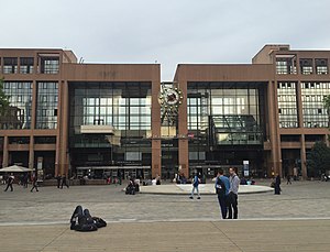
Lyon-Part-Dieu station
Railway station in Lyon, France
Distance: Approx. 1510 meters
Latitude and longitude: 45.76055556,4.85944444
Gare de la Part-Dieu (literally "Property of God" railway station) is the primary railway station of Lyon, France, located in the La Part-Dieu business district. It belongs to the Paris-Lyon-Marseille railway. Train services are mainly operated by SNCF with frequent TGV high-speed and TER regional services as well as Eurostar and Deutsche Bahn.

Tour Oxygène
Office in Lyon, France
Distance: Approx. 1683 meters
Latitude and longitude: 45.76222222,4.85694444
The Tour Oxygène (Oxygen Tower in English) is a skyscraper which rises 28 levels in the district of La Part-Dieu in the 3rd arrondissement of Lyon, France. It forms part of the Oxygen Project, which includes the office tower and a shopping center, the Cours Oxygène. The tower rises 115 meters high.

Rhônexpress
Distance: Approx. 1324 meters
Latitude and longitude: 45.7602,4.862
Rhônexpress is an express tram-train service which links central Lyon, France, with its airport, Lyon–Saint-Exupéry Airport, and the TGV railway station located there. In 2010, it is one of the most expensive airport-to-city lines in Europe per kilometer. The route is 23 kilometres (14 mi) long, and served by six tram-train sets, built by Swiss manufacturer Stadler Rail.

La Part-Dieu
Neighbourhood and central business district in Lyon, France
Distance: Approx. 1672 meters
Latitude and longitude: 45.76111111,4.85722222
La Part-Dieu (French: [la paʁ djø]) is an area of Lyon Metropolis. It is also the second largest tertiary district in France, after La Défense in Greater Paris. The area contains the Part-Dieu train station.

Tour Swiss Life
Office in Lyon, France
Distance: Approx. 1552 meters
Latitude and longitude: 45.76305556,4.85861111
The Tour Swiss Life is a skyscraper of offices located in La Part-Dieu quarter, in the 3rd arrondissement of Lyon. This 82-metre tower was built in 1989 by French architect Charles Delfante. It was the second tallest tower in Lyon before the end of the construction of the Tour Oxygène in 2010, and is now the 4th tallest, with 20 floors.

Les Brotteaux station
Distance: Approx. 1536 meters
Latitude and longitude: 45.7672,4.8598
The Gare des Brotteaux is an old railway station located in the Brotteaux quarter, in the 6th arrondissement of Lyon.

Trolleybuses in Lyon
Distance: Approx. 1510 meters
Latitude and longitude: 45.76055556,4.85944444
The Lyon trolleybus system (French: Réseau de trolleybus de Lyon) is part of the public transport network of the city and commune of Lyon, France. Opened in 1935, it combines with the Lyon Metro, the Lyon tramway network and Lyon's urban motorbus network to form an integrated system. Lyon was one of the first cities in France to utilize trolleybuses.
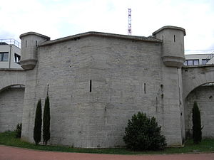
Fort Montluc
Monument in Lyon, France
Distance: Approx. 1741 meters
Latitude and longitude: 45.751789,4.862823
Fort Montluc, also known as Fort de Villeurbanne, is a fort located in the 3rd arrondissement of Lyon. The fort was built in 1831 as part of the Ceintures de Lyon, which were a series of fortifications surrounding Lyon. It is currently used as a metropolitan police station.

Tour To-Lyon
Mixed-use (office, hotel, retail) in Lyon, France
Distance: Approx. 1573 meters
Latitude and longitude: 45.7596,4.8589
Tour To-Lyon is a mixed-use skyscraper under construction in the La Part-Dieu business district of Lyon, France. The building will include 66,000 m2 of office space, 10,500 m2 of hotel space and 3,500 m2 of retail space. With a height of 170 m, it will become the second-tallest skyscraper in Lyon after Tour Incity (202 m) completed in 2015.
Synagogue Keren Or
Reform synagogue in Lyon, France
Distance: Approx. 1320 meters
Latitude and longitude: 45.769668,4.864649
Keren Or Synagogue (Hebrew: קרן אור, lit. 'Ray of Light') is a Reform Jewish congregation and synagogue, located at 15 Rue Jules Vallès in Villeurbanne, in Lyon, in the Auvergne-Rhône-Alpes region of France.
Weather in this IP's area
clear sky
16 Celsius
17 Celsius
16 Celsius
18 Celsius
1013 hPa
97 %
1013 hPa
993 hPa
10000 meters
1.03 m/s
07:10:36
20:05:55