Country:
Region:
City:
Latitude and Longitude:
Time Zone:
Postal Code:
IP information under different IP Channel
ip-api
Country
Region
City
ASN
Time Zone
ISP
Blacklist
Proxy
Latitude
Longitude
Postal
Route
Luminati
Country
Region
nw
City
velbert
ASN
Time Zone
Europe/Berlin
ISP
HKN GmbH
Latitude
Longitude
Postal
IPinfo
Country
Region
City
ASN
Time Zone
ISP
Blacklist
Proxy
Latitude
Longitude
Postal
Route
db-ip
Country
Region
City
ASN
Time Zone
ISP
Blacklist
Proxy
Latitude
Longitude
Postal
Route
ipdata
Country
Region
City
ASN
Time Zone
ISP
Blacklist
Proxy
Latitude
Longitude
Postal
Route
Popular places and events near this IP address

Velbert
Town in North Rhine-Westphalia, Germany
Distance: Approx. 1364 meters
Latitude and longitude: 51.33333333,7.05
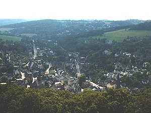
Velbert (German pronunciation: [ˈfɛlbɐt], Low Rhenish: Vèlbed) is a town in the district of Mettmann, in the German state of North Rhine-Westphalia. The town is renowned worldwide for the production of locks and fittings.
Langenberg transmission tower
Radio tower in Langenberg, Germany
Distance: Approx. 5364 meters
Latitude and longitude: 51.35527778,7.13555556
The Langenberg transmission tower (also translated as "Sender Langenberg" or "Transmission Facility Langenberg") is a broadcasting station for analog FM Radio and Digital-TV (DVB-T2 HD) signals. It is located in Langenberg, Velbert, Germany and owned and operated by Westdeutscher Rundfunk, WDR. The history of the transmitting site is very changing. The transmitter first went into service in 1927 with 60 kilowatts (kW) of power and a T-aerial hanging on two 100-metre freestanding steel-frame towers insulated against ground.

Langenberg (Rhineland)
Borough of Velbert in North Rhine-Westphalia, Germany
Distance: Approx. 4340 meters
Latitude and longitude: 51.35194444,7.12166667
Langenberg (German pronunciation: [ˈlaŋənˌbɛʁk] ) is a borough (Stadtbezirk) of Velbert, a town in North Rhine-Westphalia, Germany. Its population is 15,717 (2021). Located in this district is the famous Sender Langenberg transmission site, which transmits MW, FM, and TV broadcasting signals.
Sebo
Brand name of vacuum cleaners
Distance: Approx. 3860 meters
Latitude and longitude: 51.3091033,7.0663713
SEBO is the brand name of vacuum cleaners made by Stein & Co GmbH, a company based in the German town of Velbert. They produce a range of upright and cylinder vacuum cleaners for domestic and commercial use. SEBO stands for SEmigewerbliche BOdenpflege, German for semi-commercial floor care.

Hesper Valley Railway
Railway line in Germany
Distance: Approx. 4167 meters
Latitude and longitude: 51.37833333,7.03833333
The Hesper Valley Railway (German: Hespertalbahn) is a German heritage line running steam locomotive services between Kupferdreh Old Station and Haus Scheppen on the Baldeneysee lake in Essen. As a narrow gauge wagonway it linked opened up Erzgruben in 1867, and the Pörtingsiepen mine in 1877. The upgrading of part of the line to standard gauge followed in 1918.

Essen-Kupferdreh station
Railway station in Essen, Germany
Distance: Approx. 5396 meters
Latitude and longitude: 51.390454,7.080608
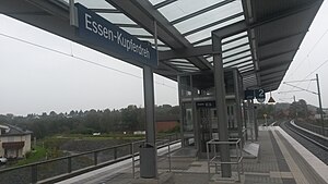
Essen-Kupferdreh station is located in the district of Kupferdreh of the city of Essen in the German state of North Rhine-Westphalia. It is on the Wuppertal-Vohwinkel–Essen-Überruhr line and is classified by Deutsche Bahn as a category 5 station. It was built between 1969 and 1979, replacing the nearby Old Kupferdreh station.

Velbert-Langenberg station
Railway station in Velbert, Germany
Distance: Approx. 4468 meters
Latitude and longitude: 51.354725,7.122444
Velbert-Langenberg station is located in the city of Velbert in the German state of North Rhine-Westphalia. It is on the Wuppertal-Vohwinkel–Essen-Überruhr line and is classified by Deutsche Bahn as a category 5 station. It was built in 1847.

Velbert-Neviges station
Railway station in Neviges, Germany
Distance: Approx. 3946 meters
Latitude and longitude: 51.313301,7.090141
Velbert-Neviges station is located in the city of Velbert in the German state of North Rhine-Westphalia. It is on the Wuppertal-Vohwinkel–Essen-Überruhr line.

Deilbach
River in North Rhine-Westphalia, Germany
Distance: Approx. 4268 meters
Latitude and longitude: 51.38,7.08
Deilbach is a river of North Rhine-Westphalia, Germany. It flows into the Ruhr in Essen-Kupferdreh.

Hardenberger Bach
River in Germany
Distance: Approx. 4393 meters
Latitude and longitude: 51.3529,7.1221
Hardenberger Bach is a river of North Rhine-Westphalia, Germany. It flows into the Deilbach in Langenberg.

Maria, Königin des Friedens
Pilgrimage church
Distance: Approx. 3905 meters
Latitude and longitude: 51.31277778,7.0875
Maria, Königin des Friedens (Mary, Queen of Peace) is a pilgrimage church and parish in Neviges, part of Velbert, North Rhine-Westphalia, Germany. The pilgrimage dates back to 1676. Neviges was the home of a Franciscan monastery from 1675 until the end of 2019.

Krupp decoy site
WWII decoy steelworks in Essen, Germany
Distance: Approx. 2468 meters
Latitude and longitude: 51.365,7.07
The Krupp night decoy site Kruppsche Nachtscheinanlage was a German decoy-site of the Krupp steelworks in Essen. It was designed to divert Allied night airstrikes in the bombing of Essen in World War II from the actual production site of the arms factory.
Weather in this IP's area
few clouds
6 Celsius
5 Celsius
5 Celsius
7 Celsius
1025 hPa
77 %
1025 hPa
994 hPa
10000 meters
1.94 m/s
4.18 m/s
189 degree
23 %
07:49:49
16:43:14
