Country:
 Denmark
Region:
City:
Latitude and Longitude:
Time Zone:
Postal Code:
IP information under different IP Channel
ip-api
Country
Region
City
ASN
Time Zone
ISP
Blacklist
Proxy
Latitude
Longitude
Postal
Route
IPinfo
Country
Region
City
ASN
Time Zone
ISP
Blacklist
Proxy
Latitude
Longitude
Postal
Route
MaxMind
Country
Region
City
ASN
Time Zone
ISP
Blacklist
Proxy
Latitude
Longitude
Postal
Route
Luminati
Country
DKRegion
84
City
helsinge
ASN
Time Zone
Europe/Copenhagen
ISP
Telenor A/S
Latitude
Longitude
Postal
db-ip
Country
Region
City
ASN
Time Zone
ISP
Blacklist
Proxy
Latitude
Longitude
Postal
Route
ipdata
Country
Region
City
ASN
Time Zone
ISP
Blacklist
Proxy
Latitude
Longitude
Postal
Route
Popular places and events near this IP address
Helsinge (municipality)
Distance: Approx. 1293 meters
Latitude and longitude: 56.0225,12.19777778
Until 1 January 2007, Helsinge was a municipality (Danish, kommune) in Frederiksborg County on the north coast of the island of Zealand (Sjælland) in eastern Denmark. It had a total population of 19,473 (2005), but in the summer months the population grew to over 36.000 people. Its last mayor was Claus Lange, a member of the Venstre (Liberal Party) political party.
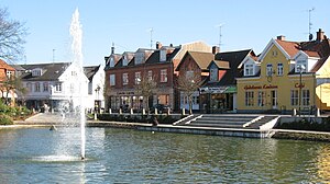
Helsinge
Town in Region Hovedstaden, Denmark
Distance: Approx. 1249 meters
Latitude and longitude: 56.02222222,12.19722222
Helsinge is the municipal seat of Gribskov Municipality in Region Hovedstaden on Zealand in Denmark. As of 1 January 2024, it has a population of 9,482.

Holbo Herred
Distance: Approx. 5473 meters
Latitude and longitude: 56.03333333,12.26666667
Holbo Herred (Holbo Hundred) was an administrative division in Frederiksborg County in the northern part of the island of Zealand, Denmark. It comprised the present-day Gribskov Municipality plus the parish of Nødebo (which today is in Hillerød Municipality). Previously, Holbo was under Strø Herred.

Gribskov Municipality
Municipality in Hovedstaden, Denmark
Distance: Approx. 4556 meters
Latitude and longitude: 56.05,12.21666667
Gribskov Municipality (Danish: Gribskov Kommune) is a municipality (Danish, kommune) in the Capital Region of Denmark. The municipality covers an area of 278 km2, and has a total population of 41,920. The municipality was created on 1 January 2007 as a merger of the former municipalities of Græsted-Gilleleje and Helsinge.
Helsinge-Hallen
Sports arena in Denmark
Distance: Approx. 1289 meters
Latitude and longitude: 56.02416667,12.18583333
Helsinge-Hallen is an indoor sports arena in Helsinge, Denmark, primarily used for handball. The arena can hold 1,600 spectators and is home to Danish Handball League team Nordsjælland Håndbold.
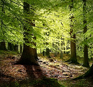
Kongernes Nordsjælland
National park in Zealand, Denmark
Distance: Approx. 1622 meters
Latitude and longitude: 56,12.2
Kongernes Nordsjælland (Royal North Zealand) is a national park in the northern region of the island of Zealand, Denmark. It opened in 2018.

Helsinge railway station
Railway station in Helsinge, Denmark
Distance: Approx. 1644 meters
Latitude and longitude: 56.02305556,12.20555556
Helsinge station is a railway station serving the town of Helsinge in North Zealand, Denmark. Helsinge station is located on the Gribskov Line from Hillerød to Tisvildeleje. The station was opened in 1897 with the opening of the Kagerup-Helsinge section of the Gribskov Line.
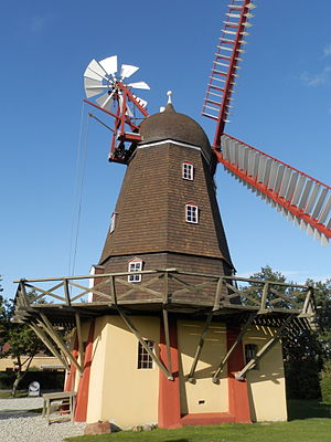
Ramløse Windmill
Smock mill in Ramløse, Gribskov Municipality, North Zealand, Denmark
Distance: Approx. 4249 meters
Latitude and longitude: 56.015864,12.118872
Ramløse Windmill (Danish: Ramløse Mølle) is a smock mill located in the northeastern corner of Ramløse, Gribskov Municipality, North Zealand, some 60 kilometres (37 mi) north west of Copenhagen, Denmark. Built in 1908, it remained in service until 1937. The mill has been restored to working order and is operated by a group of local volunteers six times a year.

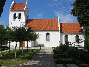
Ramløse
Town in Capital Region, Denmark
Distance: Approx. 4394 meters
Latitude and longitude: 56.01666667,12.11666667
Ramløse is a town and parish located on the northeast shore of Lake Arresø in Gribskov Municipality, North Zealand, some 50 km north of Copenhagen, Denmark. Local landmarks include Ramløse Church and Ramløse Windmill.

Kagerup
Village in Capital, Denmark
Distance: Approx. 5409 meters
Latitude and longitude: 55.99694444,12.26916667
Kagerup is a village in the Gribskov Municipality in North Zealand, Denmark. It is located six kilometers southeast of Helsinge and 10 kilometers north of Hillerød. As of 2024, it had a population of 392.
Annisse
Village in Capital, Denmark
Distance: Approx. 3524 meters
Latitude and longitude: 55.98194444,12.17277778
Annisse is a town in the Gribskov Municipality in North Zealand, Denmark. It is located five kilometers south of Helsinge and 13 kilometers northwest of Hillerød. As of 2024, it has a population of 321.

Annisse Nord
Village in Capital, Denmark
Distance: Approx. 1562 meters
Latitude and longitude: 55.99861111,12.18888889
Annisse Nord is a town in the Gribskov Municipality in North Zealand, Denmark. It is located two kilometers north of Annisse, three kilometers south of Helsinge and 15 kilometers northwest of Hillerød. As of 2024, it has a population of 1,585.
Weather in this IP's area
broken clouds
9 Celsius
7 Celsius
8 Celsius
9 Celsius
1012 hPa
88 %
1012 hPa
1009 hPa
10000 meters
3.13 m/s
6.26 m/s
219 degree
57 %
07:34:41
18:20:50