213.76.140.208 - IP Lookup: Free IP Address Lookup, Postal Code Lookup, IP Location Lookup, IP ASN, Public IP
Country:
Region:
City:
Location:
Time Zone:
Postal Code:
IP information under different IP Channel
ip-api
Country
Region
City
ASN
Time Zone
ISP
Blacklist
Proxy
Latitude
Longitude
Postal
Route
Luminati
Country
Region
06
City
lublin
ASN
Time Zone
Europe/Warsaw
ISP
Orange Polska Spolka Akcyjna
Latitude
Longitude
Postal
IPinfo
Country
Region
City
ASN
Time Zone
ISP
Blacklist
Proxy
Latitude
Longitude
Postal
Route
IP2Location
213.76.140.208Country
Region
pomorskie
City
mrzezino
Time Zone
Europe/Warsaw
ISP
Language
User-Agent
Latitude
Longitude
Postal
db-ip
Country
Region
City
ASN
Time Zone
ISP
Blacklist
Proxy
Latitude
Longitude
Postal
Route
ipdata
Country
Region
City
ASN
Time Zone
ISP
Blacklist
Proxy
Latitude
Longitude
Postal
Route
Popular places and events near this IP address
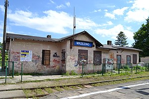
Mrzezino railway station
Railway station in Mrzezino, Poland
Distance: Approx. 1110 meters
Latitude and longitude: 54.6531,18.4131
Mrzezino railway station is a railway station serving the village of Mrzezino, in the Pomeranian Voivodeship, Poland. The station opened on 15 December 1898 and is located on the Reda–Hel railway. The train services are operated by Przewozy Regionalne.

Żelistrzewo railway station
Railway station in Żelistrzewo, Poland
Distance: Approx. 2448 meters
Latitude and longitude: 54.6742,18.4161
Żelistrzewo railway station is a railway station serving the village of Żelistrzewo, in the Pomeranian Voivodeship, Poland. The station opened on 15 December 1898 and is located on the Reda–Hel railway. The train services are operated by Przewozy Regionalne.

Reda (river)
River in Poland
Distance: Approx. 3127 meters
Latitude and longitude: 54.6411,18.4736
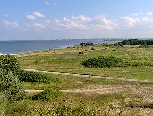
The Reda is a river in northern Poland in the Pomeranian Voivodship. It empties into the Bay of Puck, a part of Gdańsk Bay. The Reda is 45 km long, and drains about 485 square kilometers.

Coastal Landscape Park
Protected area in Poland
Distance: Approx. 2472 meters
Latitude and longitude: 54.65067,18.468308
The Polish Coastal Landscape Park (Nadmorski Park Krajobrazowy) is a protected area (Landscape Park) in northern Poland, established in 1978, covering an area of 188 square kilometres (73 sq mi). The Park lies within Pomeranian Voivodeship, in Puck County (Gmina Kosakowo, Gmina Krokowa, Gmina Puck). Within the Landscape Park are nine nature reserves.

Beka, Pomeranian Voivodeship
Settlement in Pomeranian Voivodeship, Poland
Distance: Approx. 2752 meters
Latitude and longitude: 54.65111111,18.47277778
Beka [ˈbɛka] was a settlement in the administrative district of Gmina Puck, within Puck County, Pomeranian Voivodeship, in northern Poland. It lay approximately 8 kilometres (5 mi) south-east of Puck and 33 km (21 mi) north of the regional capital Gdańsk. The first mention of the village was in 1523.
Moście Błota
Settlement in Pomeranian Voivodeship, Poland
Distance: Approx. 2329 meters
Latitude and longitude: 54.645,18.3975
Moście Błota [ˈmɔɕt͡ɕɛ ˈbwɔta] is a settlement in the administrative district of Gmina Puck, within Puck County, Pomeranian Voivodeship, in northern Poland. It lies approximately 7 kilometres (4 mi) south of Puck and 35 km (22 mi) north-west of the regional capital Gdańsk. For details of the history of the region, see History of Pomerania.
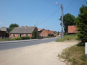
Mrzezino
Village in Pomeranian Voivodeship, Poland
Distance: Approx. 878 meters
Latitude and longitude: 54.65222222,18.41694444
Mrzezino [mʐɛˈʑinɔ] is a village in the administrative district of Gmina Puck, within Puck County, Pomeranian Voivodeship, in northern Poland. It lies approximately 6 kilometres (4 mi) south of Puck and 35 km (22 mi) north-west of the regional capital Gdańsk. It is located within the ethnocultural region of Kashubia in the historic region of Pomerania.

Osłonino
Village in Pomeranian Voivodeship, Poland
Distance: Approx. 2388 meters
Latitude and longitude: 54.66888889,18.45666667
Osłonino [ɔswɔˈninɔ] is a village in the administrative district of Gmina Puck, within Puck County, Pomeranian Voivodeship, in northern Poland. It lies approximately 6 kilometres (4 mi) south-east of Puck and 36 km (22 mi) north of the regional capital Gdańsk. It is located at the mouth of the Gizdepka river on the Bay of Puck on the coast of the Baltic Sea in the historic region of Pomerania.

Połchowo, Pomeranian Voivodeship
Village in Pomeranian Voivodeship, Poland
Distance: Approx. 3790 meters
Latitude and longitude: 54.64833333,18.37222222
Połchowo [pɔu̯ˈxɔvɔ] is a village in the administrative district of Gmina Puck, within Puck County, Pomeranian Voivodeship, in northern Poland. It lies approximately 7 kilometres (4 mi) south of Puck and 36 km (22 mi) north-west of the regional capital Gdańsk. It is located within the ethnocultural region of Kashubia in the historic region of Pomerania.
Smolno, Pomeranian Voivodeship
Village in Pomeranian Voivodeship, Poland
Distance: Approx. 2091 meters
Latitude and longitude: 54.66833333,18.40972222
Smolno [ˈsmɔlnɔ] is a village in the administrative district of Gmina Puck, within Puck County, Pomeranian Voivodeship, in northern Poland. It lies approximately 4 kilometres (2 mi) south of Puck and 37 km (23 mi) north-west of the regional capital Gdańsk. For details of the history of the region, see History of Pomerania.
Żelistrzewo
Village in Pomeranian Voivodeship, Poland
Distance: Approx. 2699 meters
Latitude and longitude: 54.67722222,18.41944444
Żelistrzewo [ʐɛlisˈtʂɛvɔ] is a village in the administrative district of Gmina Puck, within Puck County, Pomeranian Voivodeship, in northern Poland. It lies approximately 3 kilometres (2 mi) south-east of Puck and 38 km (24 mi) north of the regional capital Gdańsk. It is located in the ethnocultural region of Kashubia in the historic region of Pomerania.
Gizdepka
River in Poland
Distance: Approx. 2692 meters
Latitude and longitude: 54.6659,18.4665
Gizdepka is a river of Poland. It flows into the Bay of Puck at Osłonino.
Weather in this IP's area
overcast clouds
-2 Celsius
-9 Celsius
-3 Celsius
-2 Celsius
1012 hPa
88 %
1012 hPa
1007 hPa
10000 meters
8.38 m/s
13.63 m/s
233 degree
99 %


