Country:
 Netherlands
Region:
City:
Latitude and Longitude:
Time Zone:
Postal Code:
IP information under different IP Channel
ip-api
Country
Region
City
ASN
Time Zone
ISP
Blacklist
Proxy
Latitude
Longitude
Postal
Route
IPinfo
Country
Region
City
ASN
Time Zone
ISP
Blacklist
Proxy
Latitude
Longitude
Postal
Route
MaxMind
Country
Region
City
ASN
Time Zone
ISP
Blacklist
Proxy
Latitude
Longitude
Postal
Route
Luminati
Country
NLRegion
ze
City
domburg
ASN
Time Zone
Europe/Amsterdam
ISP
DELTA Fiber Nederland B.V.
Latitude
Longitude
Postal
db-ip
Country
Region
City
ASN
Time Zone
ISP
Blacklist
Proxy
Latitude
Longitude
Postal
Route
ipdata
Country
Region
City
ASN
Time Zone
ISP
Blacklist
Proxy
Latitude
Longitude
Postal
Route
Popular places and events near this IP address

Westkapelle, Netherlands
City in Zeeland, Netherlands
Distance: Approx. 4474 meters
Latitude and longitude: 51.52944444,3.45722222
Westkapelle (zeelandic: Weskappel, locally: Wasschappell) is a small city in the municipality of Veere on the island Walcheren, in the province Zeeland of the Netherlands. On 1 January 2021, it had a population of 2,632. Westkapelle is on the westernmost tip of Walcheren and is surrounded by the sea on three sides.

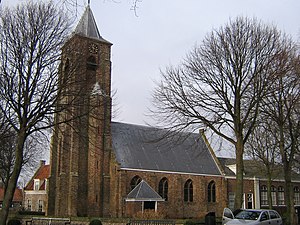
Domburg
City in Zeeland, Netherlands
Distance: Approx. 773 meters
Latitude and longitude: 51.5625,3.49638889
Domburg is a seaside resort on the North Sea, on the northwest coast of Walcheren in the Dutch province of Zeeland. It is a part of the municipality of Veere, and lies about 11 km northwest of the city of Middelburg, the provincial capital.
Oostkapelle
Village in Zeeland, Netherlands
Distance: Approx. 3418 meters
Latitude and longitude: 51.56666667,3.55083333
Oostkapelle is a village in the Dutch province of Zeeland. It is a part of the municipality of Veere, and lies about 9 km north of Middelburg. Oostkapelle was a separate municipality until 1966, when it was merged with Domburg.
Aagtekerke
Place in Zeeland, Netherlands
Distance: Approx. 1206 meters
Latitude and longitude: 51.55,3.51666667
Aagtekerke (Dutch pronunciation: [ˈaːxtəˌkɛrkə]) is a village in the Dutch province of Zeeland. It is a part of the municipality of Veere, and lies about 9 km (6 mi) northwest of Middelburg.

Grijpskerke
Village in Zeeland, Netherlands
Distance: Approx. 4779 meters
Latitude and longitude: 51.53388889,3.56166667
Grijpskerke is a village in the Dutch province of Zeeland. It is a part of the municipality of Veere and lies about 6 km northwest of Middelburg.

Meliskerke
Village in Zeeland, Netherlands
Distance: Approx. 4712 meters
Latitude and longitude: 51.51527778,3.51194444
Meliskerke is a village in the Dutch province of Zeeland. It is a part of the municipality of Veere, and lies about 8 km west of Middelburg.
Domburg-Binnen
Distance: Approx. 815 meters
Latitude and longitude: 51.5636,3.4978
Domburg-Binnen is a former municipality in the Dutch province of Zeeland. It existed until 1816, when it merged with Domburg-Buiten to form the new municipality of Domburg. The municipality of Domburg-Binnen covered the city of Domburg itself, and a few of the surrounding dunes.
Domburg-Buiten
Distance: Approx. 1634 meters
Latitude and longitude: 51.5478,3.4858
Domburg-Buiten is a former municipality in the Dutch province of Zeeland. It existed until 1816, when it merged with Domburg-Binnen to form the new municipality of Domburg. The municipality of Domburg-Buiten covered the countryside of Domburg.
Mariekerke, Netherlands
Distance: Approx. 4964 meters
Latitude and longitude: 51.51666667,3.53333333
Mariekerke is a former municipality in the Dutch province of Zeeland. The municipality was formed in a merger of Aagtekerke, Grijpskerke and Meliskerke in 1966, and existed until 1997 when it merged into the municipality of Veere. The municipality was named after the former village of Mariekerke, which is now a hamlet named Klein Mariekerke.
Westkapelle-Binnen
Distance: Approx. 5368 meters
Latitude and longitude: 51.52916667,3.44083333
Westkapelle-Binnen is a former municipality in the Dutch province of Zeeland. It existed until 1816, when it merged with Westkapelle-Buiten en Sirpoppekerke to form the new municipality of Westkapelle. The municipality consisted only of the village of Westkapelle, not including any surrounding countryside.
Westkapelle-Buiten en Sirpoppekerke
Distance: Approx. 3816 meters
Latitude and longitude: 51.53694444,3.45944444
Westkapelle-Buiten en Sirpoppekerke is a former municipality in the Dutch province of Zeeland. It existed until 1816, when it merged with Westkapelle-Binnen to form the new municipality Westkapelle. The municipality covered the countryside north and south of the town of Westkapelle, and the former hamlet Poppekerke.

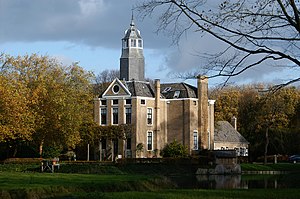
Westhove Castle
Castle in the Netherlands
Distance: Approx. 1866 meters
Latitude and longitude: 51.56982,3.52174
Westhove Castle is a castle on Walcheren, outside Oostkapelle in the province of Zeeland in The Netherlands
Weather in this IP's area
overcast clouds
14 Celsius
14 Celsius
13 Celsius
15 Celsius
1013 hPa
95 %
1013 hPa
1013 hPa
7000 meters
3.6 m/s
240 degree
100 %
08:17:12
18:44:16