213.253.120.137 - IP Lookup: Free IP Address Lookup, Postal Code Lookup, IP Location Lookup, IP ASN, Public IP
Country:
Region:
City:
Location:
Time Zone:
Postal Code:
IP information under different IP Channel
ip-api
Country
Region
City
ASN
Time Zone
ISP
Blacklist
Proxy
Latitude
Longitude
Postal
Route
Luminati
Country
Region
00
City
belgrade
ASN
Time Zone
Europe/Belgrade
ISP
SOFTNET d.o.o.
Latitude
Longitude
Postal
IPinfo
Country
Region
City
ASN
Time Zone
ISP
Blacklist
Proxy
Latitude
Longitude
Postal
Route
IP2Location
213.253.120.137Country
Region
jablanicki okrug
City
leskovac
Time Zone
Europe/Belgrade
ISP
Language
User-Agent
Latitude
Longitude
Postal
db-ip
Country
Region
City
ASN
Time Zone
ISP
Blacklist
Proxy
Latitude
Longitude
Postal
Route
ipdata
Country
Region
City
ASN
Time Zone
ISP
Blacklist
Proxy
Latitude
Longitude
Postal
Route
Popular places and events near this IP address

Leskovac
City in southern Serbia
Distance: Approx. 382 meters
Latitude and longitude: 43,21.95
Leskovac (Serbian Cyrillic: Лесковац, pronounced [lěskoʋats]) is a city and the administrative center of the Jablanica District in southern Serbia. According to the 2022 census, the city of Leskovac has 123,950 inhabitants.

Jablanica District
District of Serbia
Distance: Approx. 382 meters
Latitude and longitude: 43,21.95
The Jablanica District (Serbian: Јабланички округ, romanized: Jablanički okrug, pronounced [jâblaːnitʃkiː ôkruːɡ]) is one of nine administrative districts of Southern and Eastern Serbia. It expands in the southeastern parts of Serbia. As of the 2022 census, the district has a population of 184,502 inhabitants.
Mira Airfield
Airport in Leskovac, Serbia
Distance: Approx. 2500 meters
Latitude and longitude: 43.01873056,21.93396111
Mira Airfield (Serbian: Аеродром Мира / Aerodrom Mira) (ICAO: LYLE) is a recreational aerodrome in Serbia, located in the vicinity of the city of Leskovac (about 2.5 km north from the centre, near the road 158 that connects Leskovac–Niš). The airfield is mainly used for pilot training and sport parachuting jumping. Leskovac Airfield is primarily used for sport, tourist and agronomic purposes although there are plans to expand the airfield into a small cargo airport, and then the small airport passenger characters.

Hisar Hill
Distance: Approx. 1131 meters
Latitude and longitude: 42.99096,21.936212
The Hisar (Serbian: Хисар) is a 341-metre-tall (1,119 ft) hill near the town of Leskovac in southern Serbia. A town's symbol, the hill is known for the remains of the large, fortified Bronze Age settlement and has been declared a nature park. The evidence confirm the almost continuous habitation from the Neolithic to the Ottoman period, and as the town of Leskovac engulfs the hill, until today.
Donja Jajina
Village in Jablanica District, Serbia
Distance: Approx. 3144 meters
Latitude and longitude: 42.97,21.94222222
Donja Jajina is a village in the municipality of Leskovac, Serbia. According to the 2002 census, the village has a population of 1338 people.

Vinarce
Town in Jablanica District, Serbia
Distance: Approx. 3164 meters
Latitude and longitude: 43.01666667,21.91666667
Vinarce is a town in the municipality of Leskovac, Serbia. According to the 2002 census, the town has a population of 3090 people.
Donje Sinkovce
Town in Jablanica District, Serbia
Distance: Approx. 3182 meters
Latitude and longitude: 42.98027778,21.91555556
Donje Sinkovce (Serbian Cyrillic: Доње Синковце) is a town in Serbia. According to the 2002 census, the town has a population of 1661 people. Located on the edge of an old landslide.
Gornje Stopanje
Village in Jablanica District, Serbia
Distance: Approx. 3147 meters
Latitude and longitude: 42.99666667,21.9075
Gornje Stopanje is a village in the municipality of Leskovac, Serbia. According to the 2002 census, the town has a population of 1756 people.

Odžaklija
Distance: Approx. 483 meters
Latitude and longitude: 42.99572222,21.95105556
The Odžaklija church (Serbian: Оџаклија, Chimney church also known as the Old church, Стара црква) is an early 19th-century Serbian Orthodox church located in Leskovac, Serbia. It was built during the First Serbian Uprising of the Serbian revolution. The Ottoman Empire forbade the locals to build a church, so the people announced the building of a home to the town priest, adding a nonfunctioning chimney to fool the Turkish lords.

SRC Dubočica
Distance: Approx. 2355 meters
Latitude and longitude: 42.9772,21.9506
SRC Dubočica (Serbian Cyrillic: СРЦ Дубочица) is an indoor sporting arena located in Leskovac, Serbia. The capacity of the arena is 3,600 people. It is currently home to the Zdravlje basketball team.

Cathedral of the Holy Trinity, Leskovac
Serbian church
Distance: Approx. 497 meters
Latitude and longitude: 42.99543,21.951
The Cathedral of the Holy Trinity (Serbian Cyrillic: Саборна црква Свете Тројице) is a cathedral of Diocese of Niš, located in the center of Leskovac. It is one of the most important segments of the architectural heritage of Leskovac, today it is under state protection as a cultural monument. The initiative to build it was launched on Vidovdan in 1919.

Dubočica Stadium
Football stadium in Leskovac, Serbia
Distance: Approx. 1393 meters
Latitude and longitude: 42.9904006,21.9595868
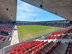
Dubočica Stadium (Serbian: Стадион Дубочица / Stadion Dubočica) is a football stadium in Leskovac, Serbia. It is the home ground of GFK Dubočica. The stadium consists of four stands with a total seating capacity of 8,136.
Weather in this IP's area
broken clouds
7 Celsius
5 Celsius
7 Celsius
7 Celsius
1018 hPa
68 %
1018 hPa
990 hPa
10000 meters
2.79 m/s
7.41 m/s
159 degree
65 %