213.253.118.5 - IP Lookup: Free IP Address Lookup, Postal Code Lookup, IP Location Lookup, IP ASN, Public IP
Country:
Region:
City:
Location:
Time Zone:
Postal Code:
IP information under different IP Channel
ip-api
Country
Region
City
ASN
Time Zone
ISP
Blacklist
Proxy
Latitude
Longitude
Postal
Route
Luminati
Country
Region
00
City
belgrade
ASN
Time Zone
Europe/Belgrade
ISP
SOFTNET d.o.o.
Latitude
Longitude
Postal
IPinfo
Country
Region
City
ASN
Time Zone
ISP
Blacklist
Proxy
Latitude
Longitude
Postal
Route
IP2Location
213.253.118.5Country
Region
beograd
City
zemun
Time Zone
Europe/Belgrade
ISP
Language
User-Agent
Latitude
Longitude
Postal
db-ip
Country
Region
City
ASN
Time Zone
ISP
Blacklist
Proxy
Latitude
Longitude
Postal
Route
ipdata
Country
Region
City
ASN
Time Zone
ISP
Blacklist
Proxy
Latitude
Longitude
Postal
Route
Popular places and events near this IP address

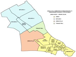
Zemun
Municipality in Belgrade, Serbia
Distance: Approx. 773 meters
Latitude and longitude: 44.85,20.4
Zemun (Serbian Cyrillic: Земун, pronounced [zěmuːn]; Hungarian: Zimony) is a municipality in the city of Belgrade, Serbia. Zemun was a separate town that was absorbed into Belgrade in 1934. It lies on the right bank of the Danube river, upstream from downtown Belgrade.

Kalvarija, Zemun
Distance: Approx. 334 meters
Latitude and longitude: 44.84083333,20.39833333
Kalvarija, also formerly known as Marija Bursać (Serbian: Калварија or Марија Бурсаћ) is an urban neighborhood of Belgrade, the capital of Serbia. It is located in Belgrade's municipality of Zemun.

Zemun Stadium
Stadium in Belgrade, Serbia
Distance: Approx. 593 meters
Latitude and longitude: 44.84794167,20.39797222
Zemun Stadium is a multi-purpose stadium in Zemun, Belgrade, Serbia tha can hold 9,600 spectators. The stadium is used mostly for football games and is the home ground of FK Zemun.
Ćukovac
Neighborhood in Belgrade, Serbia
Distance: Approx. 449 meters
Latitude and longitude: 44.84583333,20.40527778
Ćukovac (Serbian: Ћуковац) is an urban neighborhood of Belgrade, the capital of Serbia. It is located in Belgrade's municipality of Zemun.

Gardoš
Urban neighbourhood in Zemun, Belgrade, Serbia
Distance: Approx. 768 meters
Latitude and longitude: 44.84888889,20.40638889
Gardoš (Serbian Cyrillic: Гардош; Hungarian: Gárdos) is an urban neighborhood of Belgrade, the capital of Serbia. It is located in Belgrade's municipality of Zemun. Located on the slopes of the hill of the same name, with its tower and preserved old architecture, Gardoš is the major historical landmark of Zemun.

Sava Kovačević, Zemun
Distance: Approx. 750 meters
Latitude and longitude: 44.84388889,20.39166667
Sava Kovačević (Serbian Cyrillic: Сава Ковачевић) is an urban neighborhood of Belgrade, Serbia. It is located in Belgrade's municipality of Zemun.
Muhar
Neighbourhood in Belgrade, Serbia
Distance: Approx. 620 meters
Latitude and longitude: 44.84527778,20.40833333
Muhar (Serbian Cyrillic: Мухар) is an urban neighborhood of Belgrade, the capital of Serbia. It is located in the Belgrade municipality of Zemun.

Evangelical Church, Zemun
Distance: Approx. 312 meters
Latitude and longitude: 44.84111111,20.40388889
The Evangelical church in Zemun /'Serbia'/ was built in 1926–30 at the corner of Prilaz and Tošin Bunar streets. It was designed by Jewish-Croatian architect Hugo Ehrlich to serve needs of Zemun's Evangelical community at the time mostly consisted of Germans. Its plan is reminiscent of a trefoil, a rotunda with a prominent east apse and two side wings placed symmetrically in relation to the main entrance.

Monastery of St. Archangel Gabriel, Zemun
Distance: Approx. 733 meters
Latitude and longitude: 44.84127778,20.41002778
The Monastery of Saint Archangel Gabriel (Serbian: Манастир Светог Архангела Гаврила, romanized: Manastir Svetog Arhangela Gavrila), also known as the Zemun monastery (Serbian: Манастир Земун, romanized: Manastir Zemun) is a Serbian Orthodox monastery. Its church was built in 1786, on the site of an older church in the Donji Grad neighbourhood of Zemun (today part of Belgrade, Serbia). The monastery was officially established in 1990.

Church of the Holy Virgin, Zemun
Cultural monument in Belgrade, Serbia
Distance: Approx. 783 meters
Latitude and longitude: 44.84,20.41
The Church of the Birth of the Virgin Mary (known also as The Church of the Holy Virgin) is a Serbian Orthodox Church located in the center of the Zemun district in Belgrade.

White Bear Tavern
Kafana in Belgrade
Distance: Approx. 642 meters
Latitude and longitude: 44.845981,20.408145
White Bear Tavern (Serbian: Кафана "Бели медвед", romanized: Kafana "Beli medved") is a former kafana in Belgrade, in the municipality of Zemun. First mentioned in 1658, it is the oldest surviving edifice in the territory of modern Belgrade, not counting the Belgrade Fortress. However, Zemun developed completely independently from Belgrade for centuries and for the most part during the history two towns belonged to two different states.
City Park, Zemun
Park in Belgrade, Serbia
Distance: Approx. 670 meters
Latitude and longitude: 44.840842,20.408962
City Park or Zemun Park (Serbian: Градски парк у Земуну / Земунски парк) is a park in Zemun, a neighborhood of Belgrade, the capital of Serbia. Located on the rim of the Old Core of Zemun, it is considered today as one of the symbols of Zemun and one of the most beautiful parks in Belgrade.
Weather in this IP's area
moderate rain
3 Celsius
-1 Celsius
2 Celsius
3 Celsius
1018 hPa
87 %
1018 hPa
1006 hPa
10000 meters
5.66 m/s
280 degree
75 %

