213.253.113.188 - IP Lookup: Free IP Address Lookup, Postal Code Lookup, IP Location Lookup, IP ASN, Public IP
Country:
Region:
City:
Location:
Time Zone:
Postal Code:
IP information under different IP Channel
ip-api
Country
Region
City
ASN
Time Zone
ISP
Blacklist
Proxy
Latitude
Longitude
Postal
Route
Luminati
Country
Region
21
City
zagreb
ASN
Time Zone
Europe/Zagreb
ISP
SOFTNET d.o.o.
Latitude
Longitude
Postal
IPinfo
Country
Region
City
ASN
Time Zone
ISP
Blacklist
Proxy
Latitude
Longitude
Postal
Route
IP2Location
213.253.113.188Country
Region
grad zagreb
City
zagreb - centar
Time Zone
Europe/Zagreb
ISP
Language
User-Agent
Latitude
Longitude
Postal
db-ip
Country
Region
City
ASN
Time Zone
ISP
Blacklist
Proxy
Latitude
Longitude
Postal
Route
ipdata
Country
Region
City
ASN
Time Zone
ISP
Blacklist
Proxy
Latitude
Longitude
Postal
Route
Popular places and events near this IP address

Zagreb
Capital and largest city of Croatia
Distance: Approx. 5 meters
Latitude and longitude: 45.81305556,15.9775
Zagreb ( ZAH-greb Croatian: [zǎːɡreb] ) is the capital and largest city of Croatia. It is in the north of the country, along the Sava river, at the southern slopes of the Medvednica mountain. Zagreb stands near the international border between Croatia and Slovenia at an elevation of approximately 158 m (518 ft) above sea level.

Supreme Court of Croatia
Highest court in Croatia
Distance: Approx. 200 meters
Latitude and longitude: 45.81152778,15.97875
The Supreme Court of the Republic of Croatia (Croatian: Vrhovni sud Republike Hrvatske) is the highest court in the country, which ensures the uniform application of laws and equal justice to all.
Nine Views
Distance: Approx. 179 meters
Latitude and longitude: 45.8130174,15.9751946
Nine Views (Croatian: Devet pogleda) is an ambiental installation in Zagreb, Croatia which, together with the sculpture Prizemljeno Sunce (The Grounded Sun), comprises a scale model of the Solar System. Prizemljeno Sunce by Ivan Kožarić was first displayed in 1971 by the building of the Croatian National Theatre, and since then changed location a few times. Since 1994, it has been situated in Bogovićeva Street.

Kaptol, Zagreb
Distance: Approx. 210 meters
Latitude and longitude: 45.81472222,15.97888889
Kaptol is a part of Zagreb, Croatia in the Upper Town and it is the seat of the Roman Catholic archbishop of Zagreb. Due to its historical associations, in Croatian "Kaptol" is also used as a metonym for the leadership of the Roman Catholic Church in Croatia.

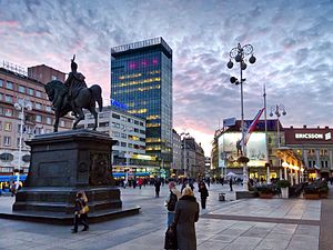
Ban Jelačić Square
Square in Zagreb, Croatia
Distance: Approx. 22 meters
Latitude and longitude: 45.81305556,15.97722222
Ban Jelačić Square (pronounced [bâːn jɛ̌lat͡ʃit͡ɕ]; Croatian: Trg bana Jelačića) is the central square of the city of Zagreb, Croatia, named after Ban Josip Jelačić. Its official name is Trg bana Josipa Jelačića and is colloquially called Jelačić plac. The square is located below Zagreb's old city cores Gradec and Kaptol, just directly south of the Dolac Market on the intersection of Ilica from the west.

Croatian Bureau of Statistics
Croatia's principal government institution in charge of statistics and census data
Distance: Approx. 172 meters
Latitude and longitude: 45.812989,15.97529
The Croatian Bureau of Statistics (Croatian: Državni zavod za statistiku or DZS) is the Croatian national statistics bureau.

Dolac Market
Monument in Zagreb, Croatia
Distance: Approx. 22 meters
Latitude and longitude: 45.81305556,15.97722222
Dolac (pronounced [dɔ̌lat͡s]) is a farmers' market located in Gornji Grad - Medveščak city district of Zagreb, Croatia. Dolac is the most visited and the best known farmer's market in Zagreb, well known for its combination of traditional open market with red umbrella stalls and a sheltered market below. It is located above Ban Jelačić Square, between the oldest parts of Zagreb, Gradec and Kaptol.

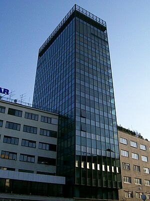
1 Ilica Street
Office building in Zagreb, Croatia
Distance: Approx. 114 meters
Latitude and longitude: 45.81277778,15.97611111
1 Ilica Street (Croatian: Neboder u Ilici, Ilički neboder, meaning "Skyscraper in Ilica") is a building located in Ilica Street overlooking Ban Jelačić Square in the Lower Town area of Zagreb, Croatia. In Croatian, the building is colloquially known under the generic title Neboder (lit. "Skyscraper") as it was the first business skyscraper in the country.

Zagreb Synagogue
Former synagogue in Zagreb, Croatia
Distance: Approx. 150 meters
Latitude and longitude: 45.81180556,15.97805556
The Zagreb Synagogue (Croatian: Zagrebačka sinagoga) was a former Orthodox Jewish congregation and synagogue, located in Zagreb, in modern-day Croatia. The synagogue building was constructed in 1867 in the Kingdom of Croatia-Slavonia within the Austrian Empire, and was used until it was demolished by the Ustaše fascist authorities in 1941 in the Axis-aligned Independent State of Croatia. The Moorish Revival synagogue, designed after the Leopoldstädter Tempel in Vienna, was located on modern-day Praška Street.

Croatian Chamber of Economy
Distance: Approx. 155 meters
Latitude and longitude: 45.8144,15.9782
Croatian Chamber of Economy (Croatian: Hrvatska gospodarska komora, abbreviation HGK), is a professional association of businesspeople in Croatia, and the oldest institution of its kind on the Croatian territory.

1918 protest in Zagreb
Event in the Kingdom of Serbs, Croats and Slovenes
Distance: Approx. 22 meters
Latitude and longitude: 45.81305556,15.97722222
On 5 December 1918, four days after the proclamation of the Kingdom of Serbs, Croats and Slovenes, the National Guards (an armed force of the National Council of the State of Slovenes, Croats and Serbs) and Sokol volunteers suppressed a protest and engaged in an armed clash against the soldiers of the 25th Regiment of the Royal Croatian Home Guard and the 53rd Regiment of the former Austro-Hungarian Common Army. National Guardsmen stopped the soldiers at the Ban Jelačić Square in Zagreb. Reasons for the protest and the conflict are not very well documented, but the soldiers who marched down Ilica Street from the Rudolf barracks towards the central city square shouted slogans against the King Peter I of Serbia and in support of republicanism and the Croatian People's Peasant Party leader Stjepan Radić.

Zagreb metropolitan area
Urban area in Croatia
Distance: Approx. 23 meters
Latitude and longitude: 45.8131,15.9772
The Zagreb metropolitan area is the metropolitan area of Zagreb. The metropolitan area covers three counties in the Croatia, with an area of 4,930 km2. The largest cities or towns within the metropolitan area are Zagreb, Velika Gorica, Samobor and Zaprešić.
Weather in this IP's area
heavy intensity rain
3 Celsius
1 Celsius
3 Celsius
3 Celsius
1004 hPa
87 %
1004 hPa
985 hPa
10000 meters
2.06 m/s
30 degree
75 %