Country:
Region:
City:
Latitude and Longitude:
Time Zone:
Postal Code:
IP information under different IP Channel
ip-api
Country
Region
City
ASN
Time Zone
ISP
Blacklist
Proxy
Latitude
Longitude
Postal
Route
Luminati
Country
ASN
Time Zone
Europe/London
ISP
Nominet UK
Latitude
Longitude
Postal
IPinfo
Country
Region
City
ASN
Time Zone
ISP
Blacklist
Proxy
Latitude
Longitude
Postal
Route
db-ip
Country
Region
City
ASN
Time Zone
ISP
Blacklist
Proxy
Latitude
Longitude
Postal
Route
ipdata
Country
Region
City
ASN
Time Zone
ISP
Blacklist
Proxy
Latitude
Longitude
Postal
Route
Popular places and events near this IP address
Littlemore
Civil parish in Oxfordshire, England
Distance: Approx. 803 meters
Latitude and longitude: 51.72,-1.227
Littlemore is a district and civil parish in Oxford, England. The civil parish includes part of Rose Hill. It is about 2+1⁄2 miles (4 km) southeast of the city centre of Oxford, between Rose Hill, Blackbird Leys, Cowley, and Sandford-on-Thames.
Sandford-on-Thames
Human settlement in England
Distance: Approx. 780 meters
Latitude and longitude: 51.713,-1.232
Sandford-on-Thames, also referred to as simply Sandford, is a village and Parish Council beside the River Thames in Oxfordshire just south of Oxford. The village is just west of the A4074 road between Oxford and Henley.

Oxford Science Park
Research park in Oxfordshire, England
Distance: Approx. 274 meters
Latitude and longitude: 51.71583333,-1.21833333
The Oxford Science Park (OSP) is a science and technology park located on the southern edge of the city of Oxford, England. It was officially opened in 1991 and is owned by Magdalen College, Oxford. The park maintains strong links with the nearby University of Oxford and currently contains just over 60 companies.
Fiddler's Elbow
Distance: Approx. 1026 meters
Latitude and longitude: 51.7125,-1.2355
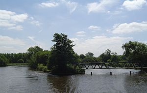
Fiddler's Elbow is the largest of a set of islands in the River Thames in England alongside and upstream of Sandford Lock, near Kennington, Oxfordshire. Fiddler's Elbow Island is in the shape of a leg of lamb with a wide expanse tapering upstream to a narrow point. The navigation channel passes to the east of the island and the main weir stream, leading to the Sandford Lasher (weir pool) passes to the west.
Oxford Academy, Oxfordshire
Academy in Oxford, Oxfordshire, England
Distance: Approx. 818 meters
Latitude and longitude: 51.72106,-1.2181194
The Oxford Academy is a coeducational secondary school and sixth form located in Littlemore, Oxford, England. Formerly Peers School, it was re-opened as an Academy in September 2008 and is the state secondary school for The Leys, Rose Hill and Littlemore..

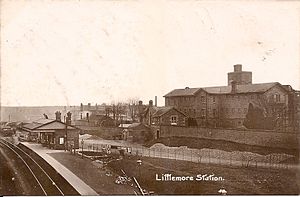
Littlemore railway station
Former railway station in Oxfordshire, England
Distance: Approx. 588 meters
Latitude and longitude: 51.71856,-1.22481
Littlemore railway station was on the Wycombe Railway and served Littlemore in Oxfordshire. Littlemore was then a village but is now a suburb of Oxford. The Wycombe Railway opened the station in 1864 as part of its extension from Thame to Oxford.

Littlemore Brook
River in Oxfordshire, England
Distance: Approx. 536 meters
Latitude and longitude: 51.7133,-1.2285
Littlemore Brook is a tributary of the River Thames in Oxfordshire, southern England. It runs from the Blackbird Leys estate in the city of Oxford behind the Kassam Stadium and through the Oxford Science Park to the south of the city, near the village of Littlemore after which it is named. It joins the Thames near Sandford-on-Thames.

Littlemore Hospital
Hospital in Oxfordshire, England
Distance: Approx. 617 meters
Latitude and longitude: 51.718,-1.2268
Littlemore Hospital was a mental health facility on Sandford Road in Littlemore, Oxfordshire.

Littlemore Railway Cutting
Distance: Approx. 1206 meters
Latitude and longitude: 51.721,-1.234
Littlemore Railway Cutting is a 0.5-hectare (1.2-acre) geological Site of Special Scientific Interest on the southern outskirts of Oxford in Oxfordshire. It is a Geological Conservation Review site. The cutting exposes limestone and clay laid down in mid-Oxfordian stage of the Late Jurassic, around 160 million years ago.
Death of Dr. Michael Meenaghan
Distance: Approx. 1269 meters
Latitude and longitude: 51.71999,-1.20523
Dr. Michael "Spike" Meenaghan was a forensic scientist at Oxford University who was shot dead through his kitchen window on 10 December 1994. He was a lecturer at the Sir William Dunn School of Pathology.
Vaccines Manufacturing and Innovation Centre
Vaccine research and manufacturing facility in Oxfordshire, England
Distance: Approx. 425 meters
Latitude and longitude: 51.7163889,-1.2161111
The Vaccines Manufacturing and Innovation Centre (VMIC) is a vaccine research and manufacturing facility under construction in Harwell Science and Innovation Campus in Oxfordshire, England. Announced in December 2018 and originally planned to be opened in 2022, its planned opening date has been brought forward to 2021 as a response to the COVID-19 pandemic. Organizations collaborating in the centre's development include Imperial College London, the London School of Hygiene and Tropical Medicine, and Oxford University.

Sandford Hydro
Hydroelectric power station in Oxford, England
Distance: Approx. 1089 meters
Latitude and longitude: 51.7115,-1.2361
Sandford Hydro is a small hydroelectric scheme located on the River Thames in Oxfordshire, England. It uses the head of water provided by the weir at Sandford Lock in Sandford-on-Thames, but is actually situated on the opposite bank of the river in Kennington. It can generate 450 kilowatts (600 hp) of electricity with its three archimedes screw turbines.
Weather in this IP's area
overcast clouds
3 Celsius
0 Celsius
2 Celsius
5 Celsius
997 hPa
96 %
997 hPa
989 hPa
10000 meters
2.57 m/s
360 degree
100 %
07:31:10
16:09:51


