Country:
Region:
City:
Latitude and Longitude:
Time Zone:
Postal Code:
IP information under different IP Channel
ip-api
Country
Region
City
ASN
Time Zone
ISP
Blacklist
Proxy
Latitude
Longitude
Postal
Route
Luminati
Country
ASN
Time Zone
Europe/Berlin
ISP
Wieske's Crew GmbH
Latitude
Longitude
Postal
IPinfo
Country
Region
City
ASN
Time Zone
ISP
Blacklist
Proxy
Latitude
Longitude
Postal
Route
db-ip
Country
Region
City
ASN
Time Zone
ISP
Blacklist
Proxy
Latitude
Longitude
Postal
Route
ipdata
Country
Region
City
ASN
Time Zone
ISP
Blacklist
Proxy
Latitude
Longitude
Postal
Route
Popular places and events near this IP address

Bille (Elbe)
River in Germany
Distance: Approx. 787 meters
Latitude and longitude: 53.54,10.02416667
The river Bille (German pronunciation: [ˈbɪlə] ) is a small, slow-flowing German river in Stormarn, Schleswig-Holstein and Hamburg, a right tributary of the Elbe. Its source is near Linau, north of the Hahnheide forest. It then flows south of Trittau, representing the border between Stormarn and Lauenburg, continues south of Reinbek and reaches the river Elbe near Billwerder.

Hamburg University of Applied Sciences
Higher education and applied research institution in Hamburg
Distance: Approx. 1127 meters
Latitude and longitude: 53.55638889,10.02194444
The Hamburg University of Applied Sciences (German: Hochschule für Angewandte Wissenschaften Hamburg) is a higher education and applied research institution located in Hamburg, Germany. Formerly known as Fachhochschule Hamburg, the Hamburg University of Applied Sciences was founded in 1970. In terms of student enrolment, the HAW is the second-largest university in Hamburg and the fourth-largest applied sciences university in Germany, with a student body of 16.454.
Al-Quds Mosque
Mosque in Hamburg, Germany
Distance: Approx. 1246 meters
Latitude and longitude: 53.55694444,10.01944444
Al-Quds Mosque was a mosque in Hamburg, Germany between 1993 and 2010 when it was shut down by German security officials. The mosque was known for preaching a radical form of Sunni Islam. The al-Quds Mosque was attended by some of the September 11 attackers including Mohamed Atta, Marwan al-Shehhi, Ramzi bin al-Shibh, and Ziad Jarrah who formed the Hamburg cell.

St. Georg, Hamburg
Quarter of Hamburg in Germany
Distance: Approx. 1062 meters
Latitude and longitude: 53.55305556,10.01527778
St. Georg (Sankt Georg; German: [ˌzaŋkt ˈɡeːɔʁk] ) is a central quarter in the borough Hamburg-Mitte of Hamburg, Germany. In 2020 the population was 11,349.

Berliner Tor station
Railway station in Hamburg, Germany
Distance: Approx. 646 meters
Latitude and longitude: 53.5525,10.02555556
Berliner Tor (German: [bɛʁˈliːnɐ ˈtoːɐ̯]; literally "Berlin Gate") is a transport hub in Hamburg, Germany, served by the Hamburg U-Bahn (underground railway) and the Hamburg S-Bahn (suburban railway). The station is located in St. Georg, part of the borough of Hamburg-Mitte.

Lohmühlenstraße station
Railway station in Hamburg, Germany
Distance: Approx. 1231 meters
Latitude and longitude: 53.55694444,10.02
Lohmühlenstraße (German pronunciation: [loːˈmyːlɛnʃtʁaːsə]) is a public transport metro station for the rapid transit trains on the line U1 located in Hamburg, Germany in the quarter St. Georg in the Hamburg-Mitte borough. The station is close to the St.

Hammerbrook station
Elevated railway station in Germany
Distance: Approx. 255 meters
Latitude and longitude: 53.54638889,10.02361111
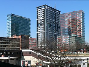
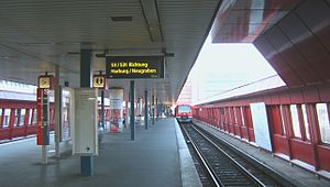
Hammerbrook is an elevated railway station on the Harburg S-Bahn line, served by the city trains of Hamburg S-Bahn. The railway station is located in Hammerbrook, Hamburg-Mitte, Hamburg, Germany.

Hammerbrook
Quarter of Hamburg in Germany
Distance: Approx. 269 meters
Latitude and longitude: 53.54527778,10.03055556
Hammerbrook () is a quarter (Stadtteil) in the Hamburg-Mitte borough of the Free and Hanseatic city of Hamburg in Germany. In 2020, the population was 5,069.

Hamburg Central Bus Station
Bus station in Hamburg, Germany
Distance: Approx. 1199 meters
Latitude and longitude: 53.55194444,10.01147222
The Hamburg Central Bus Station (abbreviated ZOB, German for Zentraler Omnibusbahnhof) is the central station for long-distance coaches in and out of Hamburg. It is located in the St. Georg district near the Hamburg Hauptbahnhof.

Hamburg Berliner Bahnhof
Former railway station in Germany
Distance: Approx. 1224 meters
Latitude and longitude: 53.54694444,10.00888889
The Berliner Bahnhof (Berlin line station) in the German city of Hamburg was the western terminus of the Berlin-Hamburg railway opened in 1846. It was previously the site of the station built in 1844 to a design by Alexis de Chateauneuf for the Hamburg-Bergedorf Railway. Berliner Bahnhof was completed in 1857 and closed in 1903.
Borgfelde
Quarter of Hamburg in Germany
Distance: Approx. 1001 meters
Latitude and longitude: 53.55475,10.03447
Borgfelde () is a quarter of Hamburg, Germany, in the borough of Hamburg-Mitte. It is located on the northern border of the borough adjacent to the borough of Hamburg-Nord. It is a more densely populated area, approximately 2 km from Hamburg city centre.

Elbriot
Annual open air music festival in Hamburg, Germany
Distance: Approx. 829 meters
Latitude and longitude: 53.54245,10.017231
Elbriot (Elbe riot) is an annual open air music festival in Hamburg, Germany, which features heavy metal and hardcore punk bands. It is organized by Hamburg Konzerte agency.
Weather in this IP's area
broken clouds
3 Celsius
-2 Celsius
3 Celsius
4 Celsius
1004 hPa
91 %
1004 hPa
1003 hPa
10000 meters
7.72 m/s
250 degree
75 %
07:51:55
16:18:38
