Country:
 Denmark
Region:
City:
Latitude and Longitude:
Time Zone:
Postal Code:
IP information under different IP Channel
ip-api
Country
Region
City
ASN
Time Zone
ISP
Blacklist
Proxy
Latitude
Longitude
Postal
Route
IPinfo
Country
Region
City
ASN
Time Zone
ISP
Blacklist
Proxy
Latitude
Longitude
Postal
Route
MaxMind
Country
Region
City
ASN
Time Zone
ISP
Blacklist
Proxy
Latitude
Longitude
Postal
Route
Luminati
Country
DKRegion
84
City
hillerod
ASN
Time Zone
Europe/Copenhagen
ISP
Telenor A/S
Latitude
Longitude
Postal
db-ip
Country
Region
City
ASN
Time Zone
ISP
Blacklist
Proxy
Latitude
Longitude
Postal
Route
ipdata
Country
Region
City
ASN
Time Zone
ISP
Blacklist
Proxy
Latitude
Longitude
Postal
Route
Popular places and events near this IP address
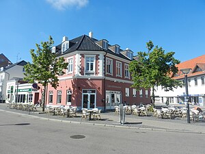
Hillerød Municipality
Municipality in Hovedstaden, Denmark
Distance: Approx. 1334 meters
Latitude and longitude: 55.93333333,12.31666667
Hillerød Municipality (Danish: Hillerød Kommune) is a municipality (Danish, kommune) in the Capital Region of Denmark. The municipality covers an area of 212.99 km2 (82.24 sq. miles), and has a total population of 54,422 (1.
Hillerød
City in Capital, Denmark
Distance: Approx. 1334 meters
Latitude and longitude: 55.93333333,12.31666667
Hillerød (Danish pronunciation: [ˈhiləˌʁœðˀ]) is a Danish town with a population of 36,227 (1 January 2024) located in the centre of North Zealand approximately 30 km to the northwest of Copenhagen, Denmark. Hillerød is the administrative centre of Hillerød Municipality and also the administrative seat of Region Hovedstaden (Capital Region of Denmark), one of the five regions in Denmark. It is most known for its large Renaissance castle, Frederiksborg Castle, now home to the Museum of National History.

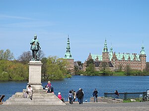
Frederiksborg Castle
Castle in Denmark
Distance: Approx. 384 meters
Latitude and longitude: 55.935,12.30083333
Frederiksborg Castle (Danish: Frederiksborg Slot) is a palatial complex in Hillerød, Denmark. It was built as a royal residence for King Christian IV of Denmark-Norway in the early 17th century, replacing an older castle acquired by Frederick II and becoming the largest Renaissance residence in Scandinavia. On three islets in the Slotssøen (castle lake), it is adjoined by a large formal garden in the Baroque style.
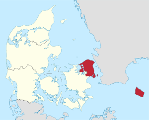
Capital Region of Denmark
Region of Denmark
Distance: Approx. 335 meters
Latitude and longitude: 55.93983333,12.3
The Capital Region of Denmark (Danish: Region Hovedstaden, pronounced [ʁekiˈoˀn ˈhoːð̩ˌstæðˀn̩]) is the easternmost administrative region of Denmark, and contains Copenhagen, the national capital. The Capital Region has 29 municipalities and a regional council consisting of 41 elected members. As of 1 August 2021, the chairperson is Lars Gaardhøj, who is a member of the Social Democrats party of Denmark.

Batzke's House
Distance: Approx. 685 meters
Latitude and longitude: 55.93610833,12.30729722
Batzke's House (Danish: Batzkes Hus) is the former gardener's house at Frederiksborg Castle in Hillerød, Denmark. It was built on a hilltop near the castle in 1720 to a design by Johan Cornelius Krieger. It was listed in 1924.
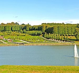
Park of Frederiksborg Castle
Distance: Approx. 433 meters
Latitude and longitude: 55.939,12.303
The park of Frederiksborg Castle (Danish: Frederiksborg Slotshave) is located to the north and west of Frederiksborg Castle in Hillerød, Denmark. It consists of a formal Baroque garden and a Romantic landscape garden.

Slotsarkaderne
Shopping mall in Hillerød, Denmark
Distance: Approx. 927 meters
Latitude and longitude: 55.9292,12.2978
Slotsarkaderne (usually styled SlotsArkaderne) is a shopping centre located in Hillerød, Denmark. It has an area of 24,000 m2 (260,000 sq ft) and contains 60 stores.
Frederiksborg Latin School
Latin school in Hillerød, Denmark
Distance: Approx. 1116 meters
Latitude and longitude: 55.92862222,12.30493056
Frederiksborg Latin School (Danish: Frederiksborg Latinskole) is a former latin school in Hillerød, Denmark. The school changed its name to Frederiksborg State School (Danish: Frederiksborg Statsskole) in 1903. The school moved to new premises in 1958 and is now called Frederiksborg Gymnasium.

Hillerød Rectory
Distance: Approx. 1077 meters
Latitude and longitude: 55.92908056,12.3051
Hillerød Rectory (Danish: Hillerød Præstegård) is located close to the central market square in Hillerød, Denmark. The building owes its current appearance to a comprehensive renovation from the 1860s but it stands on a vaulted cellar from the 17th century. A plaque above the main entrance commemorates that Peder Hersleb lived in the building from 1718 to 1724.

Stud Master's House
Distance: Approx. 380 meters
Latitude and longitude: 55.93615,12.291
The Stud Master's House (Danish: Stutmesterens Hus), situated on Frederiksværksgade, west of Frederiksborg Castle, was built for the stable master at the Royal Frederiksborg Stud in Hillerød, Denmark. It was built in 1723 to a design by Royal Building Inspector Johan Cornelius Krieger and is fairly similar to nearby Batzke's House which was also designed by Krieger. The house was in the first half of the 19th century for a while used as a school under the name Nyhuse Skole.
Annaborg
Distance: Approx. 269 meters
Latitude and longitude: 55.93508056,12.29653056
Annaborg, formerly also known as Amtsstuegården, is a Neoclassical building from 1783 now operated as a venue for temporary art exhibitions in Hillerød, Denmark. It is located adjacent to Frederiksborg Castle and was until 1939 home to the headquarters of Frederiksborg County. It was listed in the Danish registry of protected buildings and places in 1945.
Hillerød Stadium
Stadium complex in Hillerød, Denmark
Distance: Approx. 807 meters
Latitude and longitude: 55.94472222,12.29555556
Hillerød Stadium (Danish: Hillerød Stadion) is a multi-use sports complex in Hillerød, Denmark. It is currently used for football matches and is the home stadium of Hillerød Fodbold. The complex was earlier the site of the Selskov Stadium and was used for motorcycle speedway events, often with crowds in excess of 10,000.
Weather in this IP's area
broken clouds
8 Celsius
5 Celsius
8 Celsius
9 Celsius
1012 hPa
89 %
1012 hPa
1008 hPa
10000 meters
6.65 m/s
11.67 m/s
244 degree
56 %
07:34:08
18:20:30