213.231.175.59 - IP Lookup: Free IP Address Lookup, Postal Code Lookup, IP Location Lookup, IP ASN, Public IP
Country:
Region:
City:
Location:
Time Zone:
Postal Code:
IP information under different IP Channel
ip-api
Country
Region
City
ASN
Time Zone
ISP
Blacklist
Proxy
Latitude
Longitude
Postal
Route
Luminati
Country
Region
06
City
vratsa
ASN
Time Zone
Europe/Sofia
ISP
Rimex Ltd.
Latitude
Longitude
Postal
IPinfo
Country
Region
City
ASN
Time Zone
ISP
Blacklist
Proxy
Latitude
Longitude
Postal
Route
IP2Location
213.231.175.59Country
Region
vratsa
City
vratsa
Time Zone
Europe/Sofia
ISP
Language
User-Agent
Latitude
Longitude
Postal
db-ip
Country
Region
City
ASN
Time Zone
ISP
Blacklist
Proxy
Latitude
Longitude
Postal
Route
ipdata
Country
Region
City
ASN
Time Zone
ISP
Blacklist
Proxy
Latitude
Longitude
Postal
Route
Popular places and events near this IP address

Vratsa
Place in Bulgaria
Distance: Approx. 1506 meters
Latitude and longitude: 43.2,23.55
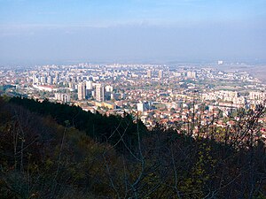
Vratsa (Bulgarian: Враца [ˈvrat͡sɐ]) is the largest city in northwestern Bulgaria and the administrative and economic centre of the municipality of Vratsa and Vratsa district. It is about 112 km (70 mi) north of Sofia, 40 km (25 mi) southeast of Montana. Situated at the foot of the Vrachanski Balkan, the town is near numerous caves, waterfalls, and rock formations.

Stadion Hristo Botev (Vratsa)
Distance: Approx. 1135 meters
Latitude and longitude: 43.20086111,23.56869444
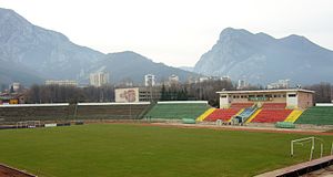
Stadion Hristo Botev (Bulgarian: Стадион "Христо Ботев", English: 'Hristo Botev Stadium') is a multi-purpose stadium in Vratsa, Bulgaria. It is currently used mostly for football matches. It has been the home of Botev Vratsa for 70 years.

Ledenika
Cave in the Balkan Mountains
Distance: Approx. 5825 meters
Latitude and longitude: 43.20444444,23.49111111
Ledenika (Bulgarian: Леденика, English: icy or glacial) is a cave in the Northwestern parts of the Balkan Mountains, 16 km away from the Bulgarian city of Vratsa. Its entrance is approximately 830 m above sea level. The cave features an abundance of galleries and impressive karst formations including stalactites and stalagmites.
Ruska Bela
Village in Bulgaria
Distance: Approx. 8585 meters
Latitude and longitude: 43.16666667,23.65
Ruska Bela (Bulgarian: Руска Бела) is a village in northwestern Bulgaria, part of Mezdra Municipality, Vratsa Province.
Chelopek
Place in Vratsa Province, Bulgaria
Distance: Approx. 9601 meters
Latitude and longitude: 43.13333333,23.61666667
Chelopek (Bulgarian: Челопек) is a village in Vratsa Municipality, Vratsa Province in northwestern Bulgaria. Located in the western Balkan Mountains, it is known as the home village of Ivan Vazov's heroine Baba Iliytsa from the tale One Bulgarian Woman. Her original timbed-framed house has been reconstructed and is currently a museum of her life and local history and ethnography.

Borov Kamak
Waterfall
Distance: Approx. 7872 meters
Latitude and longitude: 43.15305556,23.505
Borov Kamak (Bulgarian: Боров камък, "Pine Stone") is a waterfall in the Vratsa mountain, western Balkan Mountains, Bulgaria. The waterfall is situated on one the tributaries of the river Leva which flows through Vratsa. It is located on the territory of Vrachanski Balkan Nature Park.

Tower of Kurt Pasha
Tower house in Vratsa, Bulgaria
Distance: Approx. 1588 meters
Latitude and longitude: 43.20083333,23.5475
The Tower of Kurt Pasha (Bulgarian: Куртпашова кула, Kurtpashova kula), also rendered as Kurt Pasha Tower or Kurtpashov(a) Tower, is an Ottoman-era tower house in the town of Vratsa in northwest Bulgaria. Built in the 17th century, nowadays it is used as an exhibition space and souvenir shop adjacent to the Vratsa Regional Historical Museum. Like other tower houses in the Balkans from that age, the Tower of Kurt Pasha belongs to a specific type of habitable defensive tower which emerged in parts of the Balkans during a turbulent and anarchic period in the Ottoman Empire in the 17th century.

Vrachanski Balkan Nature Park
Nature park in Bulgaria
Distance: Approx. 7736 meters
Latitude and longitude: 43.172509,23.482246
Vrachanski Balkan Nature Park (Bulgarian: Природен парк „Врачански Балкан“) is a nature park in Bulgaria with an area of 30129.9 ha established on 21 December 1989.

Okolchitsa
Distance: Approx. 6782 meters
Latitude and longitude: 43.15111111,23.58388889
Okolchitsa (Bulgarian: Околчица) is a Bulgarian mountain, the highest peak in the Vratsa mountains in the west part of the Balkan Mountains. On the peak on June 2, 1876, the last battle of Hristo Botev's army took place.

Bistreshky Monastery
Medieval monastery in Vratsa Province, Bulgaria
Distance: Approx. 1506 meters
Latitude and longitude: 43.2,23.55
Bistreshky Moastery or Monastery of Saint Ivan Kasinets is medieval Bulgarian monastery located in Vratsa Province. Some of the frescoes in the church show that it was restored in the 16th century, but the establishment of the monastery dates back to the era of the Second Bulgarian Kingdom. There was a medieval fortress near the monastery—the fortress Kasina from the 12th to the 14th centuries.

Vrachanska Skaklya
Waterfall in Vrachanski Balkan Nature Park, Bulgaria
Distance: Approx. 2761 meters
Latitude and longitude: 43.18637778,23.55213611
Vrachanska Skaklya (Bulgarian: Врачанска Скакля) or Skaklya is a plunge waterfall in the Vrachanski Balkan Nature Park of Vratsa Province in northwestern Bulgaria. With a height of 141 or 148 m, it is claimed to be the highest intermittently flowing waterfall in Bulgaria and the Balkans. The waterfall lies 1.5 km south of Vratsa, behind the Kaleto hill, and can be observed from the town centre.
Weather in this IP's area
light snow
0 Celsius
0 Celsius
0 Celsius
0 Celsius
1028 hPa
70 %
1028 hPa
967 hPa
10000 meters
1.19 m/s
2.81 m/s
346 degree
100 %