Country:
 Poland
Region:
City:
Latitude and Longitude:
Time Zone:
Postal Code:
IP information under different IP Channel
ip-api
Country
Region
City
ASN
Time Zone
ISP
Blacklist
Proxy
Latitude
Longitude
Postal
Route
IPinfo
Country
Region
City
ASN
Time Zone
ISP
Blacklist
Proxy
Latitude
Longitude
Postal
Route
MaxMind
Country
Region
City
ASN
Time Zone
ISP
Blacklist
Proxy
Latitude
Longitude
Postal
Route
Luminati
Country
PLRegion
24
City
katowice
ASN
Time Zone
Europe/Warsaw
ISP
Silesian University of Technology, Computer Centre
Latitude
Longitude
Postal
db-ip
Country
Region
City
ASN
Time Zone
ISP
Blacklist
Proxy
Latitude
Longitude
Postal
Route
ipdata
Country
Region
City
ASN
Time Zone
ISP
Blacklist
Proxy
Latitude
Longitude
Postal
Route
Popular places and events near this IP address

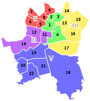
Silesian Voivodeship (1920–1939)
Former voivodeship of Poland
Distance: Approx. 2882 meters
Latitude and longitude: 50.25,19
The Silesian Voivodeship (Polish: województwo śląskie; German: Woiwodschaft Schlesien) was an autonomous province (voivodeship) of the Second Polish Republic. The bulk of its territory had formerly belonged to the German/Prussian Province of Silesia and became part of the newly reborn Poland as a result of the 1921 Upper Silesia plebiscite, the Geneva Conventions, three Upper Silesian Uprisings, and the eventual partition of Upper Silesia between Poland, Germany and Czechoslovakia. The remainder had been the easternmost portion of Austrian Silesia (see Cieszyn Silesia) which was partitioned between Poland and Czechoslovakia following the collapse of Austria-Hungary, the Polish–Czechoslovak War and the Spa Conference of 1920.

Wujek Coal Mine
Distance: Approx. 1847 meters
Latitude and longitude: 50.244775,18.98793611
Wujek Coal Mine (Polish: Kopalnia Wujek, full name in Polish: Kopalnia Węgla Kamiennego „Wujek”; German: Oheim) is a coal mine in Katowice, Poland. It is widely known in Poland as the place of the massacre of striking miners in 1981 (most often referred to by the euphemism 'Pacification'), as well as being the site of a deadly mining accident in 2009. Mining operations began in the vicinity as early as the 16th century.
Medical University of Silesia
Medical school in Katowice, Poland
Distance: Approx. 1450 meters
Latitude and longitude: 50.22495556,18.95366944
The Medical University of Silesia (Polish: Śląski Uniwersytet Medyczny) is a university located in Katowice, Poland. The university has 10,218 students and a teaching staff of 1201, including 295 professors. There are five faculties: Medicine, Dentistry, Pharmacy, Public Health, Health Sciences (includes degrees in nursing, physical therapy, dietetics).

Osiedle Witosa
Katowice District in Silesian Voivodeship, Poland
Distance: Approx. 2802 meters
Latitude and longitude: 50.25956639,18.9687325
Osiedle Witosa is a district of Katowice. It has an area of 3.49 km2 and in 2007 had 12,401 inhabitants. The Witosa estate (the Wincenty Witos estate) - a housing estate and an auxiliary unit of Katowice, located in the north-western part of the city, in the complex of northern districts, between Załęska, Załęska Hałda-Brynów and the western part and the city of Chorzów, in the historic commune of Załęże.

Ligota-Panewniki
Katowice District in Silesian Voivodeship, Poland
Distance: Approx. 912 meters
Latitude and longitude: 50.22688611,18.96260556
Ligota - Panewniki (German: Ellgoth-Panewnik; also "Idaweiche") is a district of Katowice in Poland. It has an area of 12.59 km2 and in 2007 had 31,879 inhabitants. Ligota-Panewniki is famous due to the magnificent Franciscan Basilica, the headquarters of the Franciscan Assumption Province in Poland.

Upper Silesian Coal Basin
Distance: Approx. 2882 meters
Latitude and longitude: 50.25,19
The Upper Silesian Coal Basin (USCB; Polish: Górnośląskie Zagłębie Węglowe, GZW, Czech: Hornoslezská uhelná pánev) is a coal basin in Silesia, in Poland and the Czech Republic. The Basin also contains a number of other minable resources, such as methane, cadmium, lead, silver and zinc. Coal depth is approximately 1,000 meters, and contains about 70 billion tons, with good extraction potential.

Metal Mind Productions
Polish record label
Distance: Approx. 2791 meters
Latitude and longitude: 50.2341,19.0069
Metal Mind Productions (MMP) is a Polish record label founded in 1987. The label focuses on rock and heavy metal. MMP is also publisher of Metal Hammer, the largest and the oldest heavy metal magazine.
Zadole Park
Distance: Approx. 1952 meters
Latitude and longitude: 50.21722222,18.96222222
The Zadole Park is a park in Zadole, a part of the city of Katowice in Metropolis GZM. The park features an amphitheater for 800 persons, a swimming-pool complex, a cafe and a playground for children and walking alleys. In 1906–1914 it was a place of the convention of the Polish choirs and bands within the framework of the Singing Societies existing in that region at that time. Students Hostels adjoin the center and not far from them there are tennis courts – free of charge.
Brynów
Distance: Approx. 2117 meters
Latitude and longitude: 50.24150278,18.99528056
Brynów is a district in Katowice, Poland. It is located in the central part of Katowice, south-west of the immediate center, and is divided into two subdistricts: Brynów - Osiedle Zgrzebnioka is the eastern subdistrict with 7,200 inhabitants (in 2002) Brynów - Załęska Hałda is the western subdistrict with 16,800 inhabitants (in 2002) Brynów (German: Brynow) borders the following districts of Katowice: Załęże, Osiedle Paderewskiego - Muchowiec, Śródmieście, Ligota - Panewniki, Piotrowice - Ochojec. Among the landmarks of Brynów are: Kopalnia Wujek, a coal mine known as the place the government of People's Republic of Poland brutally suppressed workers demonstration in December, 1981.
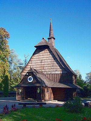
Church of St. Michael the Archangel, Katowice
Distance: Approx. 2694 meters
Latitude and longitude: 50.24086111,19.00416667
Church of St. Michael Archangel (Polish: Kościół św. Michała Archanioła w Katowicach) is one of the oldest buildings in Katowice.

Pacification of Wujek
Distance: Approx. 1847 meters
Latitude and longitude: 50.244775,18.987936
The Pacification of Wujek was a strike-breaking action by the Polish police and army at the Wujek Coal Mine in Katowice, Poland, culminating in the massacre of nine striking miners on December 16, 1981. It was part of a large-scale action aimed to break the Solidarity free trade union after the introduction of martial law in Poland in 1981. Although the strike was suppressed, in a longer term, it turned out to be a milestone towards the collapse of the authoritarian system in Poland and, ultimately, to the collapse of the Eastern Bloc.
Complex of Silesian International Schools
Independent school in Katowice, Silesia, Poland
Distance: Approx. 2722 meters
Latitude and longitude: 50.258791,18.970358
The Complex of Silesian International Schools, founded in 2007 in Katowice, is an International Centre of University of Cambridge International Examinations (CIE). Prywatne Liceum Ogolnoksztalcace im. Melchiora Wankowicza, which is a part of the Complex, offers the International Baccalaureate (IB) Diploma Programme.
Weather in this IP's area
few clouds
13 Celsius
12 Celsius
12 Celsius
14 Celsius
1025 hPa
83 %
1025 hPa
992 hPa
10000 meters
4.39 m/s
13.05 m/s
82 degree
22 %
06:27:47
18:47:16