Country:
Region:
City:
Latitude and Longitude:
Time Zone:
Postal Code:
IP information under different IP Channel
ip-api
Country
Region
City
ASN
Time Zone
ISP
Blacklist
Proxy
Latitude
Longitude
Postal
Route
IPinfo
Country
Region
City
ASN
Time Zone
ISP
Blacklist
Proxy
Latitude
Longitude
Postal
Route
MaxMind
Country
Region
City
ASN
Time Zone
ISP
Blacklist
Proxy
Latitude
Longitude
Postal
Route
Luminati
Country
Region
26
City
svilengrad
ASN
Time Zone
Europe/Sofia
ISP
A1 Bulgaria EAD
Latitude
Longitude
Postal
db-ip
Country
Region
City
ASN
Time Zone
ISP
Blacklist
Proxy
Latitude
Longitude
Postal
Route
ipdata
Country
Region
City
ASN
Time Zone
ISP
Blacklist
Proxy
Latitude
Longitude
Postal
Route
Popular places and events near this IP address
Svilengrad
Town in Haskovo, Bulgaria
Distance: Approx. 451 meters
Latitude and longitude: 41.76666667,26.2
Svilengrad (Bulgarian: Свиленград; Greek: Σβίλενγκραντ; Ottoman Turkish: Cisr-i Mustafapaşa) is a town in Haskovo Province, south-central Bulgaria, situated at the tripoint of Bulgaria, Turkey, and Greece. It is the administrative centre of the homonymous Svilengrad Municipality.

Battle of Maritsa
14th-century battle of the Serbian–Ottoman Wars
Distance: Approx. 5811 meters
Latitude and longitude: 41.71666667,26.21666667
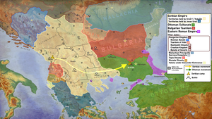
The Battle of Maritsa or Battle of Chernomen (Serbian: Marička bitka / Маричка битка; Turkish: Çirmen Muharebesi, İkinci Meriç Muharebesi in tr. Second Battle of Maritsa) took place at the Maritsa River near the village of Chernomen (present-day Ormenio, Greece) on 26 September 1371 between Ottoman forces commanded by Lala Shahin Pasha and Evrenos, and Serbian forces commanded by King Vukašin Mrnjavčević and his brother Despot Jovan Uglješa.

Old Bridge, Svilengrad
Bridge in Svilengrad, Bulgaria
Distance: Approx. 288 meters
Latitude and longitude: 41.76861111,26.19333333
Mustafa Pasha Bridge (Bulgarian: Стар мост, Star most) or The Old Bridge is a 16th-century arch bridge over the Maritsa in Svilengrad, southern Bulgaria. Completed in 1529, it was built on the order of the Ottoman vizier Çoban Mustafa Pasha. The bridge was the first major work designed by the Ottoman architect Mimar Sinan, and was part of a vakıf complex that also included a caravanserai, mosque, bazaar and hamam.

Trigono
Municipal unit in Greece
Distance: Approx. 8041 meters
Latitude and longitude: 41.7,26.23333333
Trígono (Greek: Τρίγωνο, [ˈtriɣono], meaning "triangle") is a former municipality in the Evros regional unit, East Macedonia and Thrace, Greece. Since the 2011 local government reform, it is part of the municipality Orestiada, of which it is a municipal unit. The municipal unit has an area of 392.538 km2.
Ptelea, Evros
Village in East Macedonia and Thrace, Greece
Distance: Approx. 8041 meters
Latitude and longitude: 41.7,26.23333333
Ptelea (Greek: Πτελέα, before 1951: Φτελιά Ftelia) is a village in the northern part of the Evros regional unit, Greece. It is part of the municipal unit of Trigono. It is located on the right bank of the river Evros, where it forms the border with Bulgaria.

Ormenio
Community in Greece
Distance: Approx. 5811 meters
Latitude and longitude: 41.71666667,26.21666667
Ormenio (Greek: Ορμένιο, Turkish: Çirmen, Bulgarian: Черномен, romanized: Chernomen) is the northernmost place in all of Greece. It is part of the municipal unit of Trigono in the Evros regional unit of Thrace. It is situated near the right bank of the river Evros, which forms the border with Bulgaria here.
Chernodab
Village in Haskovo Province, Bulgaria
Distance: Approx. 7324 meters
Latitude and longitude: 41.7669,26.2828
Chernodab is a village in the municipality of Svilengrad, in Haskovo Province, in southern Bulgaria.
Dimitrovche
Village in Haskovo Province, Bulgaria
Distance: Approx. 7260 meters
Latitude and longitude: 41.81666667,26.25
Dimitrovche is a village in the municipality of Svilengrad, in Haskovo Province, in southern Bulgaria.
Generalovo
Village in Haskovo Province, Bulgaria
Distance: Approx. 9205 meters
Latitude and longitude: 41.71666667,26.28333333
Generalovo (Bulgarian: Генералово [ɡɛnɛˈraɫovo]) is a village in the municipality of Svilengrad, in Haskovo Province, in southern Bulgaria.

Svilengrad Municipality
Municipality in Haskovo, Bulgaria
Distance: Approx. 451 meters
Latitude and longitude: 41.76666667,26.2
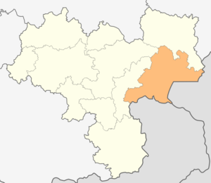
Svilengrad Municipality is a municipality in Haskovo Province, Bulgaria. The administrative centre is Svilengrad.
Ormenio railway station
Railway station in Greece
Distance: Approx. 4462 meters
Latitude and longitude: 41.7283,26.2121
Ormenio railway station (Greek: Σιδηροδρομικός Σταθμός Ορμένιο, romanized: Sidirodromikós stathmós Pythio) is a railway station that serves the village of Ormenio, Evros in Eastern Macedonia and Thrace, Greece. Located around 900 metres (3,000 ft) north of the centre of Ormenio, the station was opened by the Chemins de fer Orientaux, (now part of OSE). Today Hellenic Train operates just 1 daily Regional train; however, there are waiting rooms available.
Ptelea railway station
Railway station in Eastern Macedonia and Thrace, Greece
Distance: Approx. 7308 meters
Latitude and longitude: 41.7175755,26.2537136
Ptelea railway station (Greek: Σιδηροδρομική Στάση Πτελέας, romanized: Sidirodromiki stasi Ptelea) is a railway station situated halfway between Dikaia and Ormenio that serves the nearby village of Ptelea, Evros, in Eastern Macedonia and Thrace, Greece. Located 2.3 kilometres (1.4 mi) north of the centre of Ptelea (now part of OSE). Today Hellenic Train operates just 2 daily Regional trains to Alexandroupoli.
Weather in this IP's area
clear sky
7 Celsius
7 Celsius
7 Celsius
7 Celsius
1026 hPa
53 %
1026 hPa
1020 hPa
10000 meters
0.94 m/s
1 m/s
112 degree
07:32:02
18:27:55
